Login
Register


HYS
Hays Regional Airport
Official FAA Data Effective 2025-11-27 0901Z
Chart Supplement

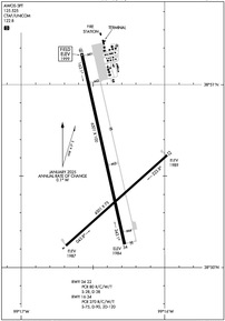
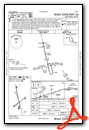
KHYS Airport Diagram
VFR Chart of KHYS
Sectional Charts at SkyVector.com
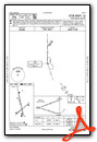
IFR Chart of KHYS
Enroute Charts at SkyVector.com
Location Information for KHYS
Coordinates: N38°50.53' / W99°16.39'Located 03 miles SE of Hays, Kansas on 545 acres of land. View all Airports in Kansas.
Surveyed Elevation is 1999 feet MSL.
Operations Data
|
|
Airport Communications
| AWOS-3PT: | 125.525 Tel. 785-625-3562 |
|---|---|
| CTAF: | 122.800 |
| UNICOM: | 122.800 |
| ASOS at RSL (21.7 E): | 128.325 785-483-5770 |
| AWOS-3PT at RCP (30.4 N): | 120.075 785-425-7042 |
| AWOS-3PT at GBD (35.9 SE): | 119.275 620-792-5019 |
- COMMUNICATIONS PRVDD BY WICHITA RADIO ON FREQ 122.3 (HAYS RCO).
- APCH/DEP CTL SVC PRVDD BY KANSAS CITY ARTCC (ZKC) ON FREQS 124.4/322.4 (RUSSELL RCAG).
Nearby Navigation Aids
|
| ||||||||||||||||||||||||||||||||||||||||||||||||||||||||||||


Runway 16/34
| Dimensions: | 6501 x 100 feet / 1982 x 30 meters | |
|---|---|---|
| Surface: | Concrete in Excellent Condition | |
| Weight Limits: | S-75, D-90, ST-120
PCR VALUE: 270/R/C/W/T
| |
| Edge Lighting: | Medium Intensity | |
| Runway 16 | Runway 34 | |
| Coordinates: | N38°51.17' / W99°16.58' | N38°50.13' / W99°16.28' |
| Elevation: | 1999.1 | 1983.8 |
| Traffic Pattern: | Left | Left |
| Runway Heading: | 167° True | 347° True |
| Declared Distances: | TORA:6501 TODA:6501 ASDA:6501 LDA:6501 | TORA:6501 TODA:6501 ASDA:6501 LDA:6501 |
| Markings: | Precision Instrument in good condition. | Precision Instrument in good condition. |
| Glide Slope Indicator | P4L (3.00° Glide Path Angle) | P4L (3.00° Glide Path Angle) |
| Approach Lights: | MALSR 1,400 Foot Medium-intensity Approach Lighting System with runway alignment indicator lights. | |
| REIL: | Yes | |
Runway 04/22
| Dimensions: | 4501 x 75 feet / 1372 x 23 meters | |
|---|---|---|
| Surface: | Concrete in Good Condition | |
| Weight Limits: | S-28, D-38
PCR VALUE: 80/R/C/W/T
| |
| Edge Lighting: | Medium Intensity | |
| Runway 04 | Runway 22 | |
| Coordinates: | N38°50.12' / W99°16.69' | N38°50.61' / W99°15.98' |
| Elevation: | 1986.7 | 1989.4 |
| Runway Heading: | 48° True | 228° True |
| Declared Distances: | TORA:4500 TODA:4500 ASDA:4500 LDA:4500 | TORA:4500 TODA:4500 ASDA:4500 LDA:4500 |
| Markings: | Non-Precision Instrument in good condition. | Non-Precision Instrument in good condition. |
| Glide Slope Indicator | P4L (3.00° Glide Path Angle) | P4L (3.00° Glide Path Angle) |
| REIL: | Yes | Yes |
Services Available
| Fuel: | 100LL (blue), Jet-A |
|---|---|
| Transient Storage: | Hangars,Tiedowns |
| Airframe Repair: | MAJOR |
| Engine Repair: | MAJOR |
| Bottled Oxygen: | NONE |
| Bulk Oxygen: | NONE |
| Other Services: | AIR FREIGHT SERVICES,CROP DUSTING SERVICES,CHARTER SERVICE,PILOT INSTRUCTION,AIRCRAFT RENTAL |
Ownership Information
| Ownership: | Publicly owned | |
|---|---|---|
| Owner: | CITY OF HAYS | |
| PO BOX 490 | ||
| HAYS, KS 67601 | ||
| 785-628-7320 | ||
| Manager: | JAMIE SALTER | |
| BOX 490 | ||
| HAYS, KS 67601 | ||
| 785-628-7370 | ||
Other Remarks
- BIRDS AND DEER ON AND IN VCNTY OF THE ARPT.
- FOR FBO HRS OF OPN CTC (785) 628-8881. FOR AFT HRS FUEL CTC FBO.
- FOR CD IF UNA TO CTC ON FSS FREQ, CTC KANSAS CITY ARTCC AT 913-254-8508.
- NO TURF TKOFS OR LDGS ALLOWED ON THE AIRFIELD.
- ACTVT MALSR RWY 34; REIL RWYS 16, 4 AND 22; PAPI RWYS 16, 34, 4, AND 22; MIRL RWYS 16/34 AND 4/22 - CTAF.
Weather Minimums


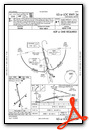
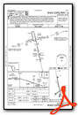
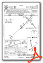
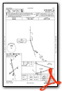
Instrument Approach Procedure (IAP) Charts


Nearby Airports with Instrument Procedures
| ID | Name | Heading / Distance | ||
|---|---|---|---|---|
 |
KRSL | Russell Municipal Airport | 085° | 21.7 |
|
KRCP | Rooks County Regional Airport | 357° | 30.3 |
|
0H1 | Trego Wakeeney Airport | 288° | 30.6 |
|
KGBD | Great Bend Municipal Airport | 146° | 35.6 |
|
48K | Ness City Municipal Airport | 233° | 37.2 |
|
KLQR | Larned-Pawnee County Airport | 166° | 39.0 |
|
KHLC | Hill City Municipal Airport | 321° | 41.5 |
|
1QK | Gove County Airport | 284° | 46.5 |
|
9K7 | Ellsworth Municipal Airport | 096° | 49.3 |
|
KPHG | Phillipsburg Municipal Airport | 357° | 53.6 |
|
KLYO | Lyons-Rice County Municipal Airport | 121° | 57.6 |
|
K79 | Jetmore Municipal Airport | 209° | 59.2 |
Fuel Providers

Airport Images
Do you have a recent image of this airport? Upload it here!


