Login
Register


REG
Louisiana Regional Airport
Official FAA Data Effective 2025-11-27 0901Z
Chart Supplement

VFR Chart of KREG
Sectional Charts at SkyVector.com
IFR Chart of KREG
Enroute Charts at SkyVector.com
Location Information for KREG
Coordinates: N30°10.28' / W90°56.42'Located 02 miles S of Gonzales, Louisiana on 188 acres of land. View all Airports in Louisiana.
Surveyed Elevation is 14 feet MSL.
Operations Data
|
|
Airport Communications
| AWOS-3PT: | 121.175 Tel. 225-644-4014 |
|---|---|
| BATON ROUGE APPROACH: | 133.225 278.3 |
| BATON ROUGE DEPARTURE: | 133.225 278.3 |
| CTAF: | 123.000 |
| UNICOM: | 123.000 |
| AWOS-3PT at APS (19.2 E): | 125.45 985-536-1009 |
| ATIS at BTR (24.3 NW): | 125.2 |
| ASOS at BTR (24.5 NW): | 225-370-8455 |
- APCH/DEP SVC PRVDD BY HOUSTON ARTCC (ZHU) ON FREQS 126.35/338.25 (LAFAYETTE RCAG) WHEN BATON ROUGE APCH CTL (BTR) CLSD.
Nearby Navigation Aids
|
| ||||||||||||||||||||||||||||||||||||||||||||||||||||||||||||


Runway 17/35
| Dimensions: | 5003 x 100 feet / 1525 x 30 meters | |
|---|---|---|
| Surface: | Asphalt in Excellent Condition | |
| Weight Limits: | S-30, D-60 | |
| Edge Lighting: | Medium Intensity | |
| Runway 17 | Runway 35 | |
| Coordinates: | N30°10.69' / W90°56.49' | N30°9.87' / W90°56.35' |
| Elevation: | 12.4 | 13.6 |
| Runway Heading: | 171° True | 351° True |
| Markings: | Non-Precision Instrument in good condition. | Non-Precision Instrument in good condition. |
| Glide Slope Indicator | P2L (3.00° Glide Path Angle) | P2L (3.00° Glide Path Angle) |
| REIL: | Yes | Yes |
| Obstacles: | 97 ft Trees 2770 ft from runway, 96 ft right of center | 51 ft Trees 1454 ft from runway, 50 ft right of center |
Services Available
| Fuel: | 100LL (blue), Jet A+ |
|---|---|
| Transient Storage: | Hangars,Tiedowns |
| Airframe Repair: | MINOR |
| Engine Repair: | MINOR |
| Bottled Oxygen: | NOT AVAILABLE |
| Bulk Oxygen: | NOT AVAILABLE |
| Other Services: | CHARTER SERVICE,PILOT INSTRUCTION,AIRCRAFT RENTAL |
Ownership Information
| Ownership: | Publicly owned | |
|---|---|---|
| Owner: | ASCENSION-ST JAMES ARPT & | TRANSPORTATION AUTHORITY. |
| 6255 AIRPORT INDUSTRIAL BLVD | ||
| GONZALES, LA 70737 | ||
| 225-644-1959 | ||
| Manager: | JASON BALL | |
| 6255 AIRPORT INDUSTRIAL BLVD | ||
| GONZALES, LA 70737 | ||
| 225-644-1959 | ||
Other Remarks
- GCO AVBL ON FREQ 135.075 THRU BATON ROUGE APCH & DE RIDDER FSS.
- DEER ON & INVOF ARPT.
- FOR CD IF UNA VIA GCO CTC BATON ROUGE APCH AT 225-354-2142 OR HOUSTON ARTCC AT 281-230-5622.
- CLIMB TO 800 AGL BFR L TURN ON DEP FROM RY 17 FOR NOISE
- 0LL 100LL AVBL SELF SVC WITH CREDIT CARD. JET A AVAILABLE AFTER HOURS CALL 225-644-1959
- DUSK-DAWN. MIRL RY 17/35 & REIL RYS 17 & 35 PRESET LOW INTST DUSK-DAWN; TO INCR INTST ACTVT - CTAF.
Weather Minimums


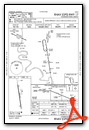
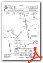
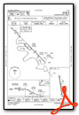
Instrument Approach Procedure (IAP) Charts
Nearby Airports with Instrument Procedures
| ID | Name | Heading / Distance | ||
|---|---|---|---|---|
 |
KAPS | Port of South Louisiana Exec Regional Airport | 105° | 19.3 |
|
KBTR | Baton Rouge Metro, Ryan Field Airport | 333° | 24.2 |
|
L83 | Thibodaux Municipal Airport | 167° | 26.0 |
|
KHDC | Hammond Northshore Regional Airport | 052° | 34.3 |
|
KPTN | Harry P Williams Memorial Airport | 217° | 34.6 |
|
KMSY | Louis Armstrong New Orleans International Airport | 106° | 37.0 |
|
KHUM | Houma-Terrebonne Airport | 157° | 39.0 |
|
KHZR | False River Regional Airport | 319° | 43.0 |
|
KNEW | Lakefront Airport | 099° | 48.1 |
|
KARA | Acadiana Regional Airport | 260° | 49.8 |
|
KNBG | New Orleans NAS Jrb (Alvin Callender Field) Airport | 113° | 51.9 |
|
KLFT | Lafayette Regional/Paul Fournet Field Airport | 272° | 54.5 |
Airport Images

By: anonymous


