Login
Register


2R6
Bunkie Municipal Airport
Official FAA Data Effective 2026-01-22 0901Z
Chart Supplement

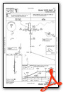
VFR Chart of 2R6
Sectional Charts at SkyVector.com
IFR Chart of 2R6
Enroute Charts at SkyVector.com
Location Information for 2R6
Coordinates: N30°57.40' / W92°14.05'Located 02 miles S of Bunkie, Louisiana on 32 acres of land. View all Airports in Louisiana.
Surveyed Elevation is 62 feet MSL.
Operations Data
|
|
Airport Communications
| POLK APPROACH: | 125.4 302.2 |
|---|---|
| POLK DEPARTURE: | 125.4 302.2 |
| CTAF: | 122.900 |
| AWOS-3PT at MKV (11.7 NE): | 124.175 318-409-4120 |
| AWOS-3PT at OPL (24.5 S): | 118.775 337-948-8560 |
| ASOS at ESF (26.5 N): | 119.425 318-484-9031 |
Nearby Navigation Aids
|
| ||||||||||||||||||||||||||||||||||||||||||||||||||||||||||||


Runway 18/36
| Dimensions: | 3005 x 75 feet / 916 x 23 meters | |
|---|---|---|
| Surface: | Asphalt in Good Condition | |
| Weight Limits: | S-8 | |
| Edge Lighting: | Medium Intensity | |
| Runway 18 | Runway 36 | |
| Coordinates: | N30°57.65' / W92°14.05' | N30°57.16' / W92°14.04' |
| Elevation: | 59.0 | 59.0 |
| Traffic Pattern: | Left | Left |
| Runway Heading: | 180° True | 360° True |
| Markings: | Non-Precision Instrument in fair condition. | Non-Precision Instrument in fair condition. |
| Glide Slope Indicator | P2L (3.00° Glide Path Angle) | P2L (3.25° Glide Path Angle) |
| REIL: | Yes | Yes |
| Obstacles: | 97 ft Trees 2752 ft from runway, 397 ft left of center | |
Services Available
| Fuel: | 100LL (blue) |
|---|---|
| Transient Storage: | Hangars,Tiedowns |
| Airframe Repair: | NONE |
| Engine Repair: | NONE |
| Bottled Oxygen: | NONE |
| Bulk Oxygen: | NONE |
| Other Services: | CROP DUSTING SERVICES,PILOT INSTRUCTION |
Ownership Information
| Ownership: | Publicly owned | |
|---|---|---|
| Owner: | TOWN OF BUNKIE | |
| PO BOX 630 | ||
| BUNKIE, LA 71322 | ||
| 318-346-7663 | ||
| Manager: | LUKE KOJIS | |
| 110 EVERGREEN ST | ||
| BUNKIE, LA 71322-1304 | ||
| 318-359-0716 | ||
Other Remarks
- THIS AIRPORT HAS BEEN SURVEYED BY THE NATIONAL GEODETIC SURVEY.
- 100LL FUEL AVBL BY APPT CALL 318-359-0716.
- FOR CD CTC POLK APCH AT 337-531-2352.
- CTC APRT MGR FOR DSGND RAMP SPACE FOR PUB USE.
- ACTVT REIL RWY 18 & 36; MIRL RWY 18/36 - CTAF. MIRL RWY 18/36 PRESET LOW INTST DUSK-DAWN; INCR INTST - CTAF.
Weather Minimums
Instrument Approach Procedure (IAP) Charts


Nearby Airports with Instrument Procedures
| ID | Name | Heading / Distance | ||
|---|---|---|---|---|
 |
KMKV | Marksville Municipal Airport | 045° | 11.9 |
|
KOPL | St Landry Parish Airport | 163° | 24.8 |
|
KACP | Allen Parish Airport | 242° | 26.5 |
|
KESF | Esler Regional Airport | 353° | 26.4 |
|
KAEX | Alexandria International Airport | 323° | 27.5 |
|
4R7 | Eunice Airport | 198° | 31.0 |
|
KHZR | False River Regional Airport | 109° | 41.6 |
|
KLFT | Lafayette Regional/Paul Fournet Field Airport | 164° | 46.8 |
|
3R7 | Jennings Airport | 208° | 48.4 |
|
0R4 | Concordia Parish Airport | 045° | 52.1 |
|
6R1 | Welsh Airport | 215° | 52.8 |
|
KDRI | Beauregard Regional Airport | 262° | 57.6 |
Airport Images
Do you have a recent image of this airport? Upload it here!


