Login
Register


LFT
Lafayette Regional/Paul Fournet Field Airport
Official FAA Data Effective 2025-11-27 0901Z
Chart Supplement

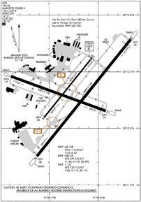
KLFT Airport Diagram
VFR Chart of KLFT
Sectional Charts at SkyVector.com
IFR Chart of KLFT
Enroute Charts at SkyVector.com
Location Information for KLFT
Coordinates: N30°12.30' / W91°59.27'Located 02 miles SE of Lafayette, Louisiana on 746 acres of land. View all Airports in Louisiana.
Surveyed Elevation is 40 feet MSL.
Operations Data
|
|
Airport Communications
| ATIS: | 134.05 |
|---|---|
| ASOS: | 134.05 Tel. 337-262-2757 |
| LAFAYETTE TOWER: | 118.5 257.8 |
| LAFAYETTE GROUND: | 121.8 |
| LAFAYETTE APPROACH: | 121.1 ;020-210 128.7 ;211-019 268.7 ;211-019 363.0 ;020-210 |
| LAFAYETTE DEPARTURE: | 121.1 ;020-210 128.7 ;211-019 268.7 ;211-019 363.0 ;020-210 |
| IC: | 121.1 ;020-210 363.0 ;020-210 |
| CLEARANCE DELIVERY: | 125.55 |
| CTAF: | 118.500 |
| EMERG: | 121.5 243.0 |
| CLASS C: | 121.1 ;020-210 128.7 ;211-019 268.7 ;211-019 363.0 ;020-210 |
| UNICOM: | 122.950 |
| ASOS at ARA (11.4 SE): | 133.325 337-365-0128 |
| AWOS-3PT at IYA (14.6 S): | 118.875 337-892-0526 |
| AWOS-3PT at OPL (22.4 N): | 118.775 337-948-8560 |
- APCH/DEP SVC PRVDD BY HOUSTON ARTCC (ZHU) ON FREQS 126.35/338.25 (LAFAYETTE RCAG) WHEN LAFAYETTE APCH CTL (LFT) CLSD.
Nearby Navigation Aids
|
| ||||||||||||||||||||||||||||||||||||||||||||||||||||||||||||


Runway 04R/22L
| Dimensions: | 8000 x 150 feet / 2438 x 46 meters | |
|---|---|---|
| Surface: | Asphalt / Grooved in Good Condition | |
| Weight Limits: | S-140, D-170, ST-290
PCR VALUE: 670/F/B/X/T
| |
| Edge Lighting: | High Intensity | |
| Runway 04R | Runway 22L | |
| Coordinates: | N30°11.75' / W91°59.62' | N30°12.78' / W91°58.67' |
| Elevation: | 38.2 | 31.9 |
| Traffic Pattern: | Right | |
| Runway Heading: | 39° True | 219° True |
| Displaced Threshold: | 342 Feet | |
| Declared Distances: | TORA:8000 TODA:8000 ASDA:8000 LDA:8000 | TORA:8000 TODA:8000 ASDA:8000 LDA:7659 |
| Markings: | Precision Instrument in good condition. | Precision Instrument in good condition. |
| Glide Slope Indicator | P4L (3.00° Glide Path Angle) | P4L (3.00° Glide Path Angle) |
| RVR Equipment | Rollout | Touchdown |
| Approach Lights: | MALSR 1,400 Foot Medium-intensity Approach Lighting System with runway alignment indicator lights. | |
| REIL: | Yes | |
| Obstacles: | 49 ft Pole 1843 ft from runway, 325 ft right of center | 57 ft Trees 1066 ft from runway, 214 ft right of center |
Runway 11/29
| Dimensions: | 5403 x 150 feet / 1647 x 46 meters | |
|---|---|---|
| Surface: | Asphalt / Grooved in Good Condition | |
| Weight Limits: | S-85, D-110, ST-175
PCR VALUE: 720/F/D/X/T
| |
| Edge Lighting: | Medium Intensity | |
| Runway 11 | Runway 29 | |
| Coordinates: | N30°12.46' / W91°59.89' | N30°12.15' / W91°58.92' |
| Elevation: | 36.5 | 33.9 |
| Traffic Pattern: | Right | Left |
| Runway Heading: | 110° True | 290° True |
| Displaced Threshold: | 248 Feet | |
| Declared Distances: | TORA:5403 TODA:5403 ASDA:5403 LDA:5403 | TORA:5403 TODA:5403 ASDA:5403 LDA:5155 |
| Markings: | Non-Precision Instrument in good condition. | Non-Precision Instrument in good condition. |
| Glide Slope Indicator | P4L (3.00° Glide Path Angle) | P4L (3.00° Glide Path Angle) |
| REIL: | Yes | Yes |
| Obstacles: | 30 ft Trees 1082 ft from runway, 134 ft right of center | 49 ft Tree 1878 ft from runway, 302 ft right of center |
Runway 04L/22R
RWY 04L/22R NOT AVBL FOR PART 121/PART 380 OPS WITH SKED PAX CARRYING OPS MORE THAN 9 PAX SEATS AND NON-SKED PAX CARRYING OPS MORE THAN 30 PAX SEATS. RWY CLSD 2230-0530. | ||
| Dimensions: | 4098 x 75 feet / 1249 x 23 meters | |
|---|---|---|
| Surface: | Asphalt in Fair Condition | |
| Weight Limits: | 11 /F/D/X/T, S-25, D-32 | |
| Edge Lighting: | Medium Intensity | |
| Runway 04L | Runway 22R | |
| Coordinates: | N30°12.10' / W91°59.55' | N30°12.62' / W91°59.06' |
| Elevation: | 40.2 | 40.7 |
| Traffic Pattern: | Right | |
| Runway Heading: | 39° True | 219° True |
| Declared Distances: | TORA:4098 TODA:4098 ASDA:4098 LDA:4098 | TORA:4098 TODA:4098 ASDA:4098 LDA:4098 |
| Markings: | Non-Precision Instrument in fair condition. | Non-Precision Instrument in fair condition. |
| Glide Slope Indicator | P2L (3.00° Glide Path Angle) | P2L (3.00° Glide Path Angle) |
| REIL: | Yes | Yes |
| Obstacles: | 27 ft Tree 996 ft from runway, 83 ft left of center | 54 ft Tree 2364 ft from runway, 5 ft right of center |
Services Available
| Fuel: | 100LL (blue), Jet-A, Jet A+ |
|---|---|
| Transient Storage: | Hangars,Tiedowns |
| Airframe Repair: | MAJOR |
| Engine Repair: | MAJOR |
| Bottled Oxygen: | LOW |
| Bulk Oxygen: | HIGH |
| Other Services: | AIR FREIGHT SERVICES,AIR AMBULANCE SERVICES,AVIONICS,CARGO HANDLING SERVICES,CHARTER SERVICE,PILOT INSTRUCTION,AIRCRAFT RENTAL,AIRCRAFT SALES |
Ownership Information
| Ownership: | Publicly owned | |
|---|---|---|
| Owner: | CITY PARISH OF LAFAYETTE | |
| 200 TERMINAL DRIVE, SUITE 200 | ||
| LAFAYETTE, LA 70508 | ||
| 337-703-4800 | ||
| Manager: | STEVEN L. PICOU, EXECUTIVE DIRECTOR | |
| 200 TERMINAL DRIVE, SUITE 200 | ||
| LAFAYETTE, LA 70508-2124 | ||
| 337-703-4800 | ||
Other Remarks
- RWY 11/29; RWY 04L/22R & RWY 04R/22L LGTD DISTANCE REMAINING SIGNS.
- CTC GND CTL PRIOR TO PUSH BACK FM TERMINAL.
- USE CTN TWR BLIND SPOTS ON TWY M EAST & WEST OF TWY E.
- FOR CD IF UNA TO CTC ON FSS FREQ, CTC HOUSTON ARTCC AT 281-230-5622.
- TAXILANE A AND ALL PRKG RAMPS ARE NON-MOVEMENT AREAS.
- ATCT HAS LTD VIS OF NORTH PRKG RAMP.
- 155 FT OIL RIG 1 NM SE OF ARPT.
- MIGRATORY BIRDS ON & INVOF ARPT.
- CALL 337-234-3100.
- DUSK-DAWN. WHEN ATCT CLSD ACTVT MALSR RWY 22L - CTAF; MIRL RWY 04L/22R NOT AVBL.
- ENGINEERED MATERIALS ARRESTING SYSTEM (EMAS) 223 FT IN LENGTH BY 170 FT IN WIDTH LCTD AT THE DER 04R.
- ENGINEERED MATERIALS ARRESTING SYSTEM (EMAS) 300 FT IN LENGTH BY 170 FT IN WIDTH LCTD AT THE DER 11.
- ENGINEERED MATERIALS ARRESTING SYSTEM (EMAS) 380.7 FT IN LENGTH BY 170 FT IN WIDTH LCTD AT THE DER 22L.
- ENGINEERED MATERIALS ARRESTING SYSTEM (EMAS) 448 FT IN LENGTH BY 170 FT IN WIDTH LCTD AT THE DER 29.
Weather Minimums


Instrument Approach Procedure (IAP) Charts


Nearby Airports with Instrument Procedures
| ID | Name | Heading / Distance | ||
|---|---|---|---|---|
 |
KARA | Acadiana Regional Airport | 151° | 11.4 |
|
KIYA | Abbeville Chris Crusta Memorial Airport | 200° | 14.6 |
|
KOPL | St Landry Parish Airport | 344° | 21.9 |
|
4R7 | Eunice Airport | 304° | 27.5 |
|
3R7 | Jennings Airport | 273° | 35.7 |
|
KHZR | False River Regional Airport | 040° | 40.5 |
|
6R1 | Welsh Airport | 273° | 43.9 |
|
KPTN | Harry P Williams Memorial Airport | 131° | 45.0 |
|
2R6 | Bunkie Municipal Airport | 344° | 46.8 |
|
KBTR | Baton Rouge Metro, Ryan Field Airport | 065° | 47.7 |
|
KACP | Allen Parish Airport | 312° | 48.8 |
|
KMKV | Marksville Municipal Airport | 355° | 53.4 |
Airport Images

By: jberryhill@sign...

By: jberryhill@sign...


Comments
FBO support
The FBO Sigature, did a great job and was really helpful, as well as friendly with our little operation there.
Jim Goolsby, Collings Foundation B-24 pilot.
Jim "Pappy" Goolsby