Login
Register


I18
Jackson County Airport
Official FAA Data Effective 2025-11-27 0901Z
Chart Supplement

VFR Chart of I18
Sectional Charts at SkyVector.com
IFR Chart of I18
Enroute Charts at SkyVector.com
Location Information for I18
Coordinates: N38°55.79' / W81°49.17'Located 06 miles SW of Ravenswood, West Virginia on 217 acres of land. View all Airports in West Virginia.
Surveyed Elevation is 758 feet MSL.
Operations Data
|
|
Airport Communications
| AWOS-2: | 121.3 Tel. 304-273-3424 |
|---|---|
| HUNTINGTON APPROACH: | 128.4 270.1 |
| HUNTINGTON DEPARTURE: | 128.4 270.1 |
| UNICOM: | 122.800 |
| CTAF: | 122.800 |
| AWOS-3 at 3I2 (13.1 W): | 119.675 304-675-4618 |
| AWOS-3PT at GAS (17.1 W): | 119.925 740-446-2149 |
| AWOS-3 at USW (23.1 E): | 118.575 304-927-0123 |
Nearby Navigation Aids
|
| ||||||||||||||||||||||||||||||||||||||||||||||||||||||||||||


Runway 04/22
| Dimensions: | 4000 x 75 feet / 1219 x 23 meters | |
|---|---|---|
| Surface: | Asphalt in Excellent Condition | |
| Weight Limits: | S-12 | |
| Edge Lighting: | Medium Intensity | |
| Runway 04 | Runway 22 | |
| Coordinates: | N38°55.50' / W81°49.38' | N38°56.07' / W81°48.96' |
| Elevation: | 738.0 | 758.2 |
| Runway Heading: | 30° True | 210° True |
| Markings: | Non-Precision Instrument in good condition. | Non-Precision Instrument in good condition. |
| Glide Slope Indicator | P2L (3.00° Glide Path Angle) | P2L (4.00° Glide Path Angle) |
| REIL: | Yes | Yes |
| Obstacles: | 35 ft Trees 201 ft from runway CTLNG OBSTN EXCEEDS A 45 DEG SLP. |
30 ft Trees 201 ft from runway, 246 ft left of center CTLNG OBSTN EXCEEDS A 45 DEG SLP. 30 FT TREES, 150-199 DSTC, 247 FT L. |
Services Available
| Fuel: | 100LL (blue) |
|---|---|
| Transient Storage: | Hangars,Tiedowns |
| Airframe Repair: | MAJOR |
| Engine Repair: | MAJOR |
| Bottled Oxygen: | NONE |
| Bulk Oxygen: | NONE |
| Other Services: | AIR AMBULANCE SERVICES,PILOT INSTRUCTION,AIRCRAFT RENTAL |
Ownership Information
| Ownership: | Publicly owned | |
|---|---|---|
| Owner: | JACKSON COUNTY CMSN | |
| 100 COURT STREET NORTH, P O BOX 800 | ||
| RIPLEY, WV 25271 | ||
| 304-373-2220 | ||
| Manager: | SAM DENNIS | |
| 912 AIRPORT RD | ||
| MILLWOOD, WV 25262 | ||
| 304-273-8114 | 304-761-6212 MGR CELL. | |
Other Remarks
- DEER AND BIRDS ON & INVOF ARPT.
- 1229 MSL STACK 1/2 MILE NW OF ARPT.
- RWY SAFETY AREA SFC UNEVEN.
- RWY 04, 50 FT DROP-OFF 200 FT FM THR.
- 15 FT TREES PARALLEL TO RWY 04, 75 FT L OF CNTRLN.
- FOR CD CTC HUNTINGTON ATCT AT 304-453-2490.
- ACTVT REIL RWY 04 & 22, PAPI RWY 04 & 22; MIRL RWY 04/22 & WINDSOCK LGT - CTAF.
Weather Minimums
Instrument Approach Procedure (IAP) Charts

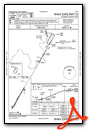
Nearby Airports with Instrument Procedures
| ID | Name | Heading / Distance | ||
|---|---|---|---|---|
 |
3I2 | Mason County Airport | 266° | 13.1 |
|
KGAS | Gallia-Meigs Regional Airport | 250° | 17.1 |
|
KUSW | Boggs Field Airport | 105° | 22.9 |
|
KUNI | Ohio University Airport | 311° | 25.5 |
|
KPKB | Mid-Ohio Valley Regional Airport | 035° | 30.6 |
|
12V | Ona Airpark Airport | 211° | 34.3 |
|
KCRW | West Virginia International Yeager Airport | 162° | 34.9 |
|
KJRO | James A Rhodes Airport | 275° | 35.6 |
|
KPMH | Greater Portsmouth Regional Airport | 263° | 48.5 |
|
KHTS | Tri-State/Milton J Ferguson Field Airport | 226° | 48.4 |
|
KDWU | Ashland Regional Airport | 242° | 48.6 |
|
I86 | Ed Newlon Field Airport | 339° | 48.9 |
Airport Images
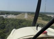
By: Big Orange Bird


