Login
Register


I86
Ed Newlon Field Airport
Official FAA Data Effective 2026-01-22 0901Z
Chart Supplement

VFR Chart of I86
Sectional Charts at SkyVector.com
IFR Chart of I86
Enroute Charts at SkyVector.com
Location Information for I86
Coordinates: N39°41.50' / W82°11.87'Located 02 miles S of New Lexington, Ohio on 53 acres of land. View all Airports in Ohio.
Surveyed Elevation is 1051 feet MSL.
Operations Data
|
|
Airport Communications
| UNICOM: | 122.800 |
|---|---|
| CTAF: | 122.800 |
| ASOS at ZZV (20.8 NE): | 127.0 740-453-8139 |
| ASOS at LHQ (21.9 W): | 118.375 740-681-1097 |
| ASOS at VTA (23.5 NW): | 121.125 740-522-1066 |
- APCH/DEP SVC PRVDD BY INDIANAPOLIS ARTCC ON FREQS 124.45/323.275 (ZANESVILLE RCAG).
Nearby Navigation Aids
|
| ||||||||||||||||||||||||||||||||||||||||||||||||||||||||||||


Runway 08/26
| Dimensions: | 3498 x 75 feet / 1066 x 23 meters | |
|---|---|---|
| Surface: | Asphalt in Good Condition | |
| Edge Lighting: | Medium Intensity | |
| Runway 08 | Runway 26 | |
| Coordinates: | N39°41.41' / W82°12.22' | N39°41.58' / W82°11.51' |
| Elevation: | 1051.7 | 1041.8 |
| Traffic Pattern: | Left | Left |
| Runway Heading: | 72° True | 252° True |
| Markings: | Non-Precision Instrument in good condition. | Non-Precision Instrument in good condition. |
| Glide Slope Indicator | P2R (3.50° Glide Path Angle) | P2L (4.00° Glide Path Angle) |
| REIL: | Yes | |
| Obstacles: | 9 ft Fence 287 ft from runway, 19 ft right of center +2-10 FT BRUSH, 0-125 FT DIST, 85 FT R. |
44 ft Trees 322 ft from runway, 250 ft right of center +8 FT FENCE, 0-124 FT DIST, 120-140 FT R. |
Services Available
| Fuel: | NONE |
|---|---|
| Transient Storage: | Hangars PRIOR CDN RQRD FOR HNGR. |
| Airframe Repair: | NONE |
| Engine Repair: | NONE |
| Bottled Oxygen: | NONE |
| Bulk Oxygen: | NONE |
Ownership Information
| Ownership: | Publicly owned | |
|---|---|---|
| Owner: | PERRY COUNTY ARPT AUTH | |
| COURTHOUSE, 105 N MAIN ST | ||
| NEW LEXINGTON, OH 43764-1262 | ||
| 330-687-2160 | ||
| Manager: | LAWRENCE NASH | |
| 1870 AIRPORT RD | ||
| NEW LEXINGTON, OH 43764-9681 | ||
| 740-605-1932 | ||
Other Remarks
- DEER & TURKEYS ON & INVOF ARPT.
- FOR CD CTC COLUMBUS APCH AT 614-338-8537.
- ACTVT REIL RWY 26; MIRL RWY 08/26 - CTAF.
Weather Minimums

Instrument Approach Procedure (IAP) Charts
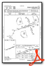
Nearby Airports with Instrument Procedures
| ID | Name | Heading / Distance | ||
|---|---|---|---|---|
 |
KZZV | Zanesville Municipal Airport | 042° | 20.7 |
|
KLHQ | Fairfield County Airport | 280° | 21.6 |
|
KVTA | Licking County Regional Airport | 328° | 23.4 |
|
KUNI | Ohio University Airport | 182° | 28.8 |
|
I10 | Noble County Airport | 077° | 31.3 |
|
KCDI | Cambridge Municipal Airport | 059° | 33.3 |
|
KLCK | Rickenbacker International Airport | 282° | 34.6 |
|
KCMH | John Glenn Columbus International Airport | 299° | 36.9 |
|
KCYO | Pickaway County Memorial Airport | 254° | 37.9 |
|
I40 | Richard Downing Airport | 023° | 40.4 |
|
KPKB | Mid-Ohio Valley Regional Airport | 120° | 40.9 |
|
KRZT | Ross County Airport | 248° | 41.1 |
Airport Images

By: tshiverd


