Login
Register


I93
Breckinridge County Airport
Official FAA Data Effective 2026-01-22 0901Z
Chart Supplement

VFR Chart of I93
Sectional Charts at SkyVector.com
IFR Chart of I93
Enroute Charts at SkyVector.com
Location Information for I93
Coordinates: N37°47.09' / W86°26.48'Located 01 miles E of Hardinsburg, Kentucky on 87 acres of land. View all Airports in Kentucky.
Surveyed Elevation is 732 feet MSL.
Operations Data
|
|
Airport Communications
| AWOS-3PT: | 123.625 Tel. 270-580-4012 |
|---|---|
| LOUISVILLE APPROACH: | 123.675 327.0 |
| LOUISVILLE DEPARTURE: | 123.675 327.0 |
| CTAF: | 122.900 |
| AWOS-3 at KY8 (22.2 NW): | 119.775 270-295-3565 |
| ATIS at FTK (23.4 E): | 109.6 |
| AWOS-3 at EKX (25.2 E): | 118.55 270-763-6433 |
Nearby Navigation Aids
|
| ||||||||||||||||||||||||||||||||||||||||||||||||||||||||||||


Runway 10/28
| Dimensions: | 4000 x 75 feet / 1219 x 23 meters | |
|---|---|---|
| Surface: | Concrete in Good Condition | |
| Weight Limits: | 11 /R/C/W/U | |
| Edge Lighting: | Medium Intensity | |
| Runway 10 | Runway 28 | |
| Coordinates: | N37°47.13' / W86°26.89' | N37°47.05' / W86°26.06' |
| Elevation: | 714.2 | 732.1 |
| Traffic Pattern: | Left | Left |
| Markings: | Non-Precision Instrument in fair condition. | Non-Precision Instrument in fair condition. |
| Glide Slope Indicator | P2L (3.10° Glide Path Angle) | P2L (3.00° Glide Path Angle) |
| REIL: | Yes | Yes |
Services Available
| Fuel: | 100LL (blue) |
|---|---|
| Transient Storage: | Tiedowns |
| Airframe Repair: | NONE |
| Engine Repair: | NONE |
| Bottled Oxygen: | NONE |
| Bulk Oxygen: | NONE |
Ownership Information
| Ownership: | Publicly owned | |
|---|---|---|
| Owner: | BRECKINRIDGE CO ARPT BOARD | |
| BOX 742 | ||
| HARDINSBURG, KY 40143 | ||
| (270) 580-4465 | ||
| Manager: | BRECKINRIDGE CO ARPT BOARD | |
| 799 OAK STREET | ||
| HARDINSBURG, KY 40143 | ||
| (270) 456-6062 | AIR BOARD CHAIR - MILLER MONARCH. | |
Other Remarks
- FUEL AVBL 24 HRS W/CREDIT CARD
- FOR CD CTC LOUISVILLE APCH AT 502-375-7499
- ACTVT REIL RYS 10 & 28; PAPI RYS 10 & 28; MIRL RY 10/28 - 122.9.
Weather Minimums

Instrument Approach Procedure (IAP) Charts
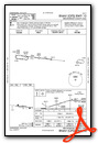
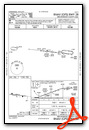
Nearby Airports with Instrument Procedures
| ID | Name | Heading / Distance | ||
|---|---|---|---|---|
 |
KTEL | Perry County Municipal Airport | 319° | 18.4 |
|
KY8 | Hancock County/Ron Lewis Field Airport | 297° | 22.2 |
|
KFTK | Godman AAF Airport | 071° | 23.5 |
|
M20 | Leitchfield-Grayson County Airport | 159° | 24.6 |
|
KEKX | Addington Field Airport | 103° | 25.3 |
|
KJQD | Ohio County Airport | 225° | 27.6 |
|
KOWB | Owensboro/Daviess County Regional Airport | 265° | 34.6 |
|
KHNB | Huntingburg Airport | 319° | 36.9 |
|
KSDF | Louisville Muhammad Ali International Airport | 054° | 40.8 |
|
KFRH | French Lick Municipal Airport | 347° | 44.2 |
|
KBRY | Samuels Field Airport | 087° | 44.8 |
|
KLOU | Bowman Field Airport | 053° | 45.4 |
Airport Images

By: Big Orange Bird


