Login
Register


EKX
Addington Field Airport
Official FAA Data Effective 2026-02-19 0901Z
Chart Supplement

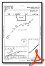
VFR Chart of KEKX
Sectional Charts at SkyVector.com
IFR Chart of KEKX
Enroute Charts at SkyVector.com
Location Information for KEKX
Coordinates: N37°41.16' / W85°55.50'Located 04 miles W of Elizabethtown, Kentucky on 210 acres of land. View all Airports in Kentucky.
Surveyed Elevation is 775 feet MSL.
Operations Data
|
|
Airport Communications
| AWOS-3: | 118.55 Tel. 270-763-6433 |
|---|---|
| LOUISVILLE APPROACH: | 123.675 327.0 |
| LOUISVILLE DEPARTURE: | 123.675 327.0 |
| CLEARANCE DELIVERY: | 119.45 |
| UNICOM: | 123.075 |
| CTAF: | 123.075 |
| ATIS at FTK (13.5 N): | 109.6 |
| AWOS-3 at BRY (21.4 E): | 119.925 502-348-1867 |
| AWOS-3PT at I93 (25.3 W): | 123.625 270-580-4012 |
Nearby Navigation Aids
|
| ||||||||||||||||||||||||||||||||||||||||||||||||||||||||||||


Runway 05/23
| Dimensions: | 6001 x 100 feet / 1829 x 30 meters | |
|---|---|---|
| Surface: | Asphalt in Good Condition | |
| Weight Limits: | 21 /F/C/X/T, S-50, D-77 | |
| Edge Lighting: | Medium Intensity | |
| Runway 05 | Runway 23 | |
| Coordinates: | N37°40.82' / W85°55.95' | N37°41.50' / W85°55.05' |
| Elevation: | 750.4 | 775.6 |
| Runway Heading: | 47° True | 227° True |
| Markings: | Precision Instrument in good condition. | Non-Precision Instrument in good condition. |
| Glide Slope Indicator | P4L (3.00° Glide Path Angle) | P4L (3.00° Glide Path Angle) |
| REIL: | Yes | Yes |
Services Available
| Fuel: | 100LL (blue), Jet A+ |
|---|---|
| Transient Storage: | Hangars,Tiedowns |
| Airframe Repair: | MAJOR |
| Engine Repair: | MAJOR |
| Bottled Oxygen: | NOT AVAILABLE |
| Bulk Oxygen: | NOT AVAILABLE |
| Other Services: | AVIONICS,PILOT INSTRUCTION,AIRCRAFT RENTAL |
Ownership Information
| Ownership: | Publicly owned | |
|---|---|---|
| Owner: | ELIZABETHTOWN AIRPORT BOARD | |
| 1828 KITTY HAWK DR | ||
| ELIZABETHTOWN, KY 42701 | ||
| 270-737-8388 | DONALD WISE. | |
| Manager: | ROGER LAWSON | |
| 1828 KITTY HAWK DRIVE | ||
| ELIZABETHTOWN, KY 42701 | ||
| 270-737-8388 | 270-769-9100. | |
Other Remarks
- PAJA, BIRDS ON & INVOF ARPT.
- FOR CD CTC LOUISVILLE APCH AT 502-375-7499
- TWY D CLSD TO ACFT WITH WINGSPAN MORE THAN 50 FT OR MORE THAN 12500 LBS GWT.
- AFT HR - 270-766-8420. FUEL AVBL H24 WITH CREDIT CARD.
- ACTVT REIL RWY 05 & 23; MIRL RWY 05/23 - CTAF. PAPI RWY 05 & 23 OPR CONSLY.
Weather Minimums

Instrument Approach Procedure (IAP) Charts


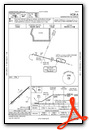
Nearby Airports with Instrument Procedures
| ID | Name | Heading / Distance | ||
|---|---|---|---|---|
 |
KFTK | Godman AAF Airport | 350° | 13.4 |
|
KBRY | Samuels Field Airport | 069° | 21.7 |
|
M20 | Leitchfield-Grayson County Airport | 223° | 23.5 |
|
I93 | Breckinridge County Airport | 283° | 25.3 |
|
KSDF | Louisville Muhammad Ali International Airport | 016° | 30.6 |
|
6I2 | Lebanon Springfield/George Hoerter Field Airport | 095° | 32.7 |
|
KLOU | Bowman Field Airport | 020° | 34.8 |
|
KAAS | Taylor County Airport | 123° | 35.3 |
|
KGLW | Glasgow Municipal Airport | 182° | 39.2 |
|
KTEL | Perry County Municipal Airport | 298° | 41.6 |
|
KJVY | Clark Regional Airport | 012° | 41.7 |
|
KJQD | Ohio County Airport | 253° | 46.2 |
Airport Images
 from NE of Rwy 23")
By: 2flaps

By: Big Orange Bird


