Login
Register


SDF
Louisville Muhammad Ali International Airport
Official FAA Data Effective 2026-01-22 0901Z
Chart Supplement

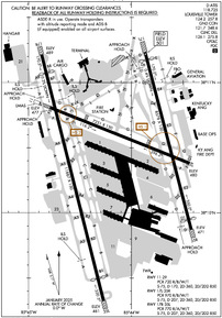
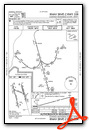
KSDF Airport Diagram
VFR Chart of KSDF
Sectional Charts at SkyVector.com
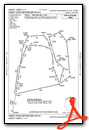
IFR Chart of KSDF
Enroute Charts at SkyVector.com
Location Information for KSDF
Coordinates: N38°10.45' / W85°44.19'Located 04 miles S of Louisville, Kentucky on 1200 acres of land. View all Airports in Kentucky.
Surveyed Elevation is 500 feet MSL.
Operations Data
|
|
Airport Communications
| D-ATIS: | 118.725 |
|---|---|
| ASOS: | Tel. 502-676-6814 |
| LOUISVILLE TOWER: | 124.2 257.8 |
| LOUISVILLE GROUND: | 121.7 348.6 |
| LOUISVILLE APPROACH: | 123.675 ;170-349 132.075 ;350-169 132.075 134.15 327.0 |
| LOUISVILLE DEPARTURE: | 123.675 ;170-349 132.075 ;350-169 132.075 327.0 |
| IC: | 132.075 |
| CLEARANCE DELIVERY: | 126.1 275.8 |
| EMERG: | 121.5 243.0 |
| CLASS C: | 123.675 ;170-349 132.075 ;350-169 327.0 |
| ANG OPS: | 268.1 |
| UNICOM: | 122.950 |
| ATIS at LOU (4.7 NE): | 124.15 |
| ASOS at LOU (4.8 NE): | 502-473-0693 |
| AWOS-3 at JVY (12.0 N): | 118.575 812-246-1278 |
- ASDE-X IN USE. OPERATE TRANSPONDERS WITH ALTITUDE REPORTING MODE AND ADS-B (IF EQUIPPED) ENABLED ON ALL AIRPORT SURFACES.
Nearby Navigation Aids
|
| ||||||||||||||||||||||||||||||||||||||||||||||||||||||||||||


Runway 17R/35L
| Dimensions: | 11887 x 150 feet / 3623 x 46 meters | |
|---|---|---|
| Surface: | Concrete / Grooved in Good Condition | |
| Weight Limits: | S-75, D-207, ST-360, DT-850
PCR VALUE: 770/R/A/W/T
| |
| Edge Lighting: | High Intensity | |
| Runway 17R | Runway 35L | |
| Coordinates: | N38°11.22' / W85°44.93' | N38°9.32' / W85°44.30' |
| Elevation: | 489.3 | 461.3 |
| Runway Heading: | 165° True | 345° True |
| Displaced Threshold: | 846 Feet | 1040 Feet |
| Declared Distances: | TORA:11095 TODA:11095 ASDA:11095 LDA:10000 | TORA:11290 TODA:11290 ASDA:11290 LDA:10000 |
| Markings: | Precision Instrument in good condition. | Precision Instrument in good condition. |
| Glide Slope Indicator | P4R (3.00° Glide Path Angle) | P4L (3.00° Glide Path Angle) |
| RVR Equipment | Touchdown Midfield Rollout | Touchdown Midfield Rollout |
| Approach Lights: | MALSR 1,400 Foot Medium-intensity Approach Lighting System with runway alignment indicator lights. | ALSF2 Standard 2,400 Foot High-intensity Approach Lighting System with sequenced flashers, CATEGORY II or III Configuration. |
| Centerline Lights: | Yes | Yes |
Runway 17L/35R
| Dimensions: | 8578 x 150 feet / 2615 x 46 meters | |
|---|---|---|
| Surface: | Concrete / Grooved in Good Condition | |
| Weight Limits: | S-75, D-207, ST-360, DT-850
PCR VALUE: 970/R/B/W/T
| |
| Edge Lighting: | High Intensity | |
| Runway 17L | Runway 35R | |
| Coordinates: | N38°11.24' / W85°43.88' | N38°9.87' / W85°43.41' |
| Elevation: | 500.8 | 471.3 |
| Runway Heading: | 165° True | 345° True |
| Displaced Threshold: | 328 Feet | 449 Feet |
| Declared Distances: | TORA:8579 TODA:8579 ASDA:8129 LDA:7800 | TORA:8579 TODA:8579 ASDA:8250 LDA:7800 |
| Markings: | Precision Instrument in good condition. | Precision Instrument in good condition. |
| Glide Slope Indicator | P4L (3.00° Glide Path Angle) | P4R (3.00° Glide Path Angle) |
| RVR Equipment | Touchdown Midfield Rollout | Touchdown Midfield Rollout |
| Approach Lights: | MALSR 1,400 Foot Medium-intensity Approach Lighting System with runway alignment indicator lights. | ALSF2 Standard 2,400 Foot High-intensity Approach Lighting System with sequenced flashers, CATEGORY II or III Configuration. |
| Centerline Lights: | Yes | Yes |
Runway 11/29
| Dimensions: | 7251 x 150 feet / 2210 x 46 meters | |
|---|---|---|
| Surface: | Concrete / Wire Combed in Good Condition | |
| Weight Limits: | S-75, D-170, ST-360, DT-850
PCR VALUE: 720/R/B/W/T
| |
| Edge Lighting: | High Intensity | |
| Runway 11 | Runway 29 | |
| Coordinates: | N38°10.81' / W85°44.84' | N38°10.38' / W85°43.43' |
| Elevation: | 476.5 | 480.0 |
| Traffic Pattern: | Left | Left |
| Runway Heading: | 111° True | 291° True |
| Declared Distances: | TORA:7250 TODA:7250 ASDA:6946 LDA:6946 | TORA:7250 TODA:7250 ASDA:7250 LDA:7250 |
| Markings: | Basic in good condition. | Precision Instrument in good condition. |
| Glide Slope Indicator | P4L (3.00° Glide Path Angle) | P4L (3.00° Glide Path Angle) |
| RVR Equipment | Rollout | Touchdown |
| Approach Lights: | MALSR 1,400 Foot Medium-intensity Approach Lighting System with runway alignment indicator lights. | |
| Obstacles: | 55 ft Building 1375 ft from runway, 325 ft right of center | |
Services Available
| Fuel: | 100LL (blue), Jet-A, Jet A+ |
|---|---|
| Transient Storage: | Hangars,Tiedowns |
| Airframe Repair: | MAJOR |
| Engine Repair: | MAJOR |
| Bottled Oxygen: | LOW |
| Bulk Oxygen: | NONE |
| Other Services: | AIR FREIGHT SERVICES,AVIONICS,CARGO HANDLING SERVICES,CHARTER SERVICE |
Ownership Information
| Ownership: | Publicly owned | |
|---|---|---|
| Owner: | LOUISVILLE REGIONAL ARPT AUTH | |
| 700 ADMINISTRATION DRIVE | ||
| LOUISVILLE, KY 40209 | ||
| 502-380-8200 | ||
| Manager: | DAN MANN | |
| 700 ADMINISTRATION DRIVE | ||
| LOUISVILLE, KY 40209 | ||
| 502-380-8200 | ||
Other Remarks
- BIRDS ON & INVOF ARPT.
- TAIL HGT 65 FT OR GTR 24 HR PPR.
- ANG: FAA GP 6 ACFT 24 HR PPR.
- CTN: CONST IN PROG; FQT RWY & TWY CLOSURES PSBL.
- ANG/123TAC RECON.
- LINE UP & WAIT WAIVER IN EFCT SS-SR AT INT OF RWY 17R AT TWY B8 OR AT TWY A8 & INT OF RWY 35L AT TWY A OR AT TWY B.
- ANG: DUTY HR 1200-2000Z/DT 1300-2100Z MON-THU; 1200-1800Z/DT 1300-1900Z FRI. APVL AUTH 123 AW/OGC; BASE OPS D741-4581/4584/ C502-413-4581/4584. ENG START & TAXI CLNC - DERBY OPS.
- TWY E INTXN DEP 7700 FT AVBL.
- STD DEP POINTS AT TWY B8 & TWY A8. REQS USE OF RWY 17R EXTN. TKOF AT TWY B8 ASDA/TORA/TODA 10245 FT.
- STD DEP POINTS AT TWY A & TWY B; REQS USE OF RWY 35L EXTN; TKOF AT TWY A & TWY B ASDA/TORA/TODA 10250 FT.
- TWY E2 INTXN DEP 6300 FT AVBL.
Weather Minimums


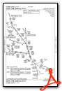
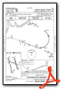
Standard Terminal Arrival (STAR) Charts


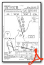
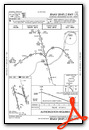
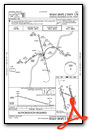
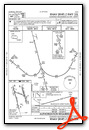
Instrument Approach Procedure (IAP) Charts
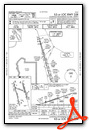
- ILS OR LOC RWY 17L
- ILS OR LOC RWY 17R

- ILS OR LOC RWY 35L
- ILS OR LOC RWY 35R
- ILS RWY 35L (SA CAT I)
- ILS RWY 35R (SA CAT I)
- ILS RWY 35L (CAT II - III)
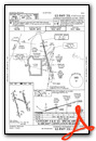
- ILS RWY 35R (CAT II - III)

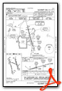
- RNAV (RNP) Z RWY 17L
- RNAV (RNP) Z RWY 17R
- RNAV (RNP) Z RWY 29
- RNAV (RNP) Z RWY 35L
- RNAV (RNP) Z RWY 35R
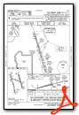
- RNAV (GPS) Y RWY 17L

- RNAV (GPS) Y RWY 17R

- RNAV (GPS) Y RWY 29

- RNAV (GPS) Y RWY 35L

- RNAV (GPS) Y RWY 35R

- LOC RWY 29

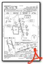
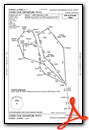
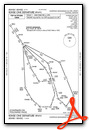
Departure Procedure (DP) Charts


Nearby Airports with Instrument Procedures
| ID | Name | Heading / Distance | ||
|---|---|---|---|---|
 |
KLOU | Bowman Field Airport | 046° | 4.7 |
|
KJVY | Clark Regional Airport | 359° | 11.5 |
|
KFTK | Godman AAF Airport | 214° | 19.5 |
|
KBRY | Samuels Field Airport | 152° | 24.3 |
|
KEKX | Addington Field Airport | 197° | 30.6 |
|
KIMS | Madison Regional Airport | 019° | 37.4 |
|
KFFT | Capital City Airport | 089° | 39.3 |
|
6I2 | Lebanon Springfield/George Hoerter Field Airport | 143° | 40.0 |
|
I93 | Breckinridge County Airport | 235° | 40.8 |
|
KSER | Freeman Municipal Airport | 349° | 45.7 |
|
KTEL | Perry County Municipal Airport | 258° | 46.2 |
|
KFRH | French Lick Municipal Airport | 295° | 46.9 |
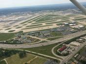
Airport Images

By: 2flaps
By: Flying-Tenticles


