Login
Register


RRT
Warroad International Memorial Airport
Official FAA Data Effective 2026-02-19 0901Z
Chart Supplement

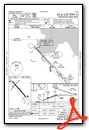
VFR Chart of KRRT
Sectional Charts at SkyVector.com
IFR Chart of KRRT
Enroute Charts at SkyVector.com
Location Information for KRRT
Coordinates: N48°56.49' / W95°20.91'Located 02 miles NW of Warroad, Minnesota on 320 acres of land. View all Airports in Minnesota.
Surveyed Elevation is 1075 feet MSL.
Operations Data
|
|
Airport Communications
| AWOS-3: | 119.925 Tel. 218-386-1813 |
|---|---|
| UNICOM: | 123.050 |
| CTAF: | 123.050 |
| AWOS-3PT at ROX (14.6 W): | 118.075 218-463-1803 |
| AWOS-3 at FGN (28.6 NE): | 118.375 218-223-4023 |
| ASOS at BDE (31.8 SE): | 126.775 218-634-3080 |
- APCH/DEP SVC PRVDD BY MINNEAPOLIS ARTCC ON FREQS 134.75/251.1 (ROSEAU RCAG).
Nearby Navigation Aids
|
| ||||||||||||||||||||||||||||||||||||||||||


Runway 13/31
| Dimensions: | 5400 x 100 feet / 1646 x 30 meters | |
|---|---|---|
| Surface: | Asphalt in Good Condition | |
| Weight Limits: | S-30, D-40 | |
| Edge Lighting: | High Intensity | |
| Runway 13 | Runway 31 | |
| Coordinates: | N48°56.76' / W95°21.25' | N48°56.09' / W95°20.36' |
| Elevation: | 1072.5 | 1074.3 |
| Traffic Pattern: | Left | Left |
| Runway Heading: | 139° True | 319° True |
| Markings: | Precision Instrument in good condition. | Precision Instrument in good condition. |
| Glide Slope Indicator | P4L (3.00° Glide Path Angle) | P4L (3.00° Glide Path Angle) |
| Approach Lights: | MALSR 1,400 Foot Medium-intensity Approach Lighting System with runway alignment indicator lights. | MALSR 1,400 Foot Medium-intensity Approach Lighting System with runway alignment indicator lights. |
Runway 04/22
CLSD WINTER MONTHS. | ||
| Dimensions: | 2987 x 150 feet / 910 x 46 meters | |
|---|---|---|
| Surface: | Turf in Good Condition | |
| Runway 04 | Runway 22 | |
| Coordinates: | N48°56.42' / W95°21.34' | N48°56.78' / W95°20.84' |
| Elevation: | 1073.1 | 1069.9 |
| Runway Heading: | 42° True | 222° True |
| Markings: | Non-Standard in good condition. | Non-Standard in good condition. |
Services Available
| Fuel: | 100LL (blue), Jet-A |
|---|---|
| Transient Storage: | Hangars,Tiedowns FOR HNGR CALL AMGR. |
| Airframe Repair: | NONE |
| Engine Repair: | NONE |
| Bottled Oxygen: | NONE |
| Bulk Oxygen: | NONE |
Ownership Information
| Ownership: | Publicly owned | |
|---|---|---|
| Owner: | CITY OF WARROAD | |
| CITY HALL, PO BOX 50 | ||
| WARROAD, MN 56763-0050 | ||
| 218-386-1454 | ||
| Manager: | MATT RACHUY | |
| PO BOX 50, 36955 COUNTY ROAD 13 | ||
| WARROAD, MN 56763-0050 | ||
| 218-386-1691 | ||
Other Remarks
- DEER & BIRDS ON & INVOF ARPT.
- CUST AVBL 1 HR PPR CALL 218-386-1676, CELL 218-689-3880, OTR 218-386-2796.
- GCO AVBL ON FREQ 121.725 (MINNEAPOLIS CENTER AND FLIGHT SERVICES).
- FOR CD IF UNA TO CTC ON FSS FREQ, CTC MINNEAPOLIS ARTCC AT 651-463-5588.
- CALM WIND RWY.
- MKD WITH YELLOW CONES.
- MKD WITH YELLOW CONES.
- 0LL FUEL AVBL H24 SELF SVC VIA CREDIT CARD.
- ACTVT OR INCR INTST MALSR RWY 13 & 31; HIRL RWY 13/31 - CTAF. PAPI RWY 13 & 31 OPR CONSLY; HIRL RWY 13/31 PRESET LOW INTST. PCL UNAVBL DURG DALGT HRS.
Weather Minimums


Instrument Approach Procedure (IAP) Charts


Nearby Airports with Instrument Procedures
| ID | Name | Heading / Distance | ||
|---|---|---|---|---|
 |
KROX | Roseau Municipal/Rudy Billberg Field Airport | 249° | 14.7 |
|
KBDE | Baudette International Airport | 113° | 31.9 |
|
KTVF | Thief River Falls Regional Airport | 212° | 62.3 |
|
KHCO | Hallock Municipal Airport | 260° | 64.2 |
|
D37 | Warren Municipal Airport | 230° | 70.6 |
|
KPMB | Pembina Municipal Airport | 270° | 74.8 |
|
KINL | Falls International/Einarson Field Airport | 105° | 80.5 |
|
KFSE | Fosston Municipal/Anderson Field Airport | 192° | 82.7 |
|
KCKN | Crookston Municipal/Kirkwood Field Airport | 218° | 83.4 |
|
KGAF | Hutson Field Airport | 248° | 86.6 |
|
KBJI | Bemidji Regional Airport | 168° | 87.5 |
|
2C8 | Cavalier Municipal Airport | 264° | 91.0 |
Airport Images
Do you have a recent image of this airport? Upload it here!


