Login
Register


ROX
Roseau Municipal/Rudy Billberg Field Airport
Official FAA Data Effective 2026-01-22 0901Z
Chart Supplement

VFR Chart of KROX
Sectional Charts at SkyVector.com
IFR Chart of KROX
Enroute Charts at SkyVector.com
Location Information for KROX
Coordinates: N48°51.38' / W95°41.82'Located 02 miles E of Roseau, Minnesota on 260 acres of land. View all Airports in Minnesota.
Surveyed Elevation is 1060 feet MSL.
Operations Data
|
|
Airport Communications
| AWOS-3PT: | 118.075 Tel. 218-463-1803 |
|---|---|
| UNICOM: | 122.800 |
| CTAF: | 122.800 |
| AWOS-3 at RRT (14.7 E): | 119.925 218-386-1813 |
| AWOS-3 at FGN (41.8 NE): | 118.375 218-223-4023 |
| ASOS at BDE (43.6 E): | 126.775 218-634-3080 |
- APCH/DEP SVC PRVDD BY MINNEAPOLIS ARTCC ON FREQS 134.75/251.1 (ROSEAU RCAG).
Nearby Navigation Aids
|
| ||||||||||||||||||||||||||||||||||||||||||


Runway 16/34
| Dimensions: | 4400 x 75 feet / 1341 x 23 meters | |
|---|---|---|
| Surface: | Asphalt in Fair Condition | |
| Weight Limits: | S-30, D-40 | |
| Edge Lighting: | Medium Intensity | |
| Runway 16 | Runway 34 | |
| Coordinates: | N48°51.81' / W95°42.01' | N48°51.10' / W95°41.76' |
| Elevation: | 1046.0 | 1060.0 |
| Traffic Pattern: | Left | Left |
| Runway Heading: | 166° True | 346° True |
| Markings: | Non-Precision Instrument in good condition. | Non-Precision Instrument in good condition. |
| Glide Slope Indicator | P2L (3.00° Glide Path Angle) | P2L (3.00° Glide Path Angle) |
| Approach Lights: | MALSF 1,400 Foot Medium-intensity Approach Lighting System with sequenced flashers. | |
| REIL: | Yes | |
Runway 06/24
CLSD WINTER MONTHS. | ||
| Dimensions: | 2097 x 250 feet / 639 x 76 meters | |
|---|---|---|
| Surface: | Turf in Good Condition | |
| Runway 06 | Runway 24 | |
| Coordinates: | N48°51.14' / W95°41.91' | N48°51.27' / W95°41.42' |
| Elevation: | 1057.8 | 1056.3 |
| Traffic Pattern: | Left | Left |
| Runway Heading: | 69° True | 249° True |
| Markings: | None | None |
Services Available
| Fuel: | 100LL (blue), Jet-A |
|---|---|
| Transient Storage: | Hangars,Tiedowns |
| Airframe Repair: | NONE |
| Engine Repair: | NONE |
| Bottled Oxygen: | NONE |
| Bulk Oxygen: | NONE |
| Other Services: | CROP DUSTING SERVICES,AIR AMBULANCE SERVICES,AIRCRAFT SALES |
Ownership Information
| Ownership: | Publicly owned | |
|---|---|---|
| Owner: | CITY OF ROSEAU | |
| 121 CENTER ST E, STE 202, PO BOX 307 | ||
| ROSEAU, MN 56751-0307 | ||
| 218-463-1542 | ||
| Manager: | TODD PETERSON | |
| 121 CENTER ST E, PO BOX 307 | ||
| ROSEAU, MN 56751-0307 | ||
| 218-689-0047 | ||
Other Remarks
- FOR CD IF UNA TO CTC ON FSS FREQ, CTC MINNEAPOLIS ARTCC AT 651-463-5588.
- 0LL FUEL AVBL H24 VIA CREDIT CARD.
- ACTVT OR INCR INTST MALSF RWY 16; NSTD REIL RWY 34; PAPI RWY 16 & 34; MIRL RWY 16/34 - CTAF. NSTD REIL RWY 34 OPR CONSLY DUSK-0000; MIRL RWY 16/34 PRESET LOW INTST.
Weather Minimums


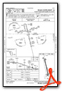
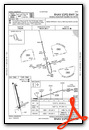
Instrument Approach Procedure (IAP) Charts
Nearby Airports with Instrument Procedures
| ID | Name | Heading / Distance | ||
|---|---|---|---|---|
 |
KRRT | Warroad International Memorial Airport | 069° | 14.7 |
|
KBDE | Baudette International Airport | 099° | 43.7 |
|
KHCO | Hallock Municipal Airport | 263° | 49.8 |
|
KTVF | Thief River Falls Regional Airport | 202° | 51.3 |
|
D37 | Warren Municipal Airport | 225° | 56.8 |
|
KPMB | Pembina Municipal Airport | 275° | 61.3 |
|
KCKN | Crookston Municipal/Kirkwood Field Airport | 211° | 71.3 |
|
KGAF | Hutson Field Airport | 248° | 71.9 |
|
KFSE | Fosston Municipal/Anderson Field Airport | 182° | 75.9 |
|
2C8 | Cavalier Municipal Airport | 267° | 76.8 |
|
KGFK | Grand Forks International Airport | 227° | 80.4 |
|
D14 | Fertile Municipal Airport | 197° | 81.9 |
Airport Images

By: winglet714


