Login
Register


EBD
Southern West Virginia Regional Airport
Official FAA Data Effective 2025-12-25 0901Z
Chart Supplement

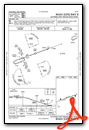
VFR Chart of KEBD
Sectional Charts at SkyVector.com
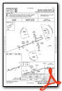
IFR Chart of KEBD
Enroute Charts at SkyVector.com
Location Information for KEBD
Coordinates: N37°40.91' / W82°7.32'Located 08 miles E of Williamson, West Virginia on 400 acres of land. View all Airports in West Virginia.
Surveyed Elevation is 1883 feet MSL.
Operations Data
|
|
Airport Communications
| CTAF: | 122.800 |
|---|---|
| UNICOM: | 122.800 |
| AWOS-3PT at 6L4 (14.3 NE): | 119.375 304-752-0814 |
| AWOS-3PT at PBX (22.3 W): | 121.225 606-437-6701 |
| AWOS-3 at SJS (24.8 W): | 120.175 606-298-4143 |
- APCH/DEP SVC PRVDD BY INDIANAPOLIS ARTCC ON FREQS 126.575/257.85 (BLUEFIELD RCAG).
Nearby Navigation Aids
|
| ||||||||||||||||||||||||||||||||||||||||||||||||||||||


Runway 08/26
| Dimensions: | 5001 x 75 feet / 1524 x 23 meters | |
|---|---|---|
| Surface: | Asphalt in Fair Condition | |
| Edge Lighting: | Medium Intensity | |
| Runway 08 | Runway 26 | |
| Coordinates: | N37°40.77' / W82°7.81' | N37°41.05' / W82°6.84' |
| Elevation: | 1826.8 | 1883.0 |
| Runway Heading: | 70° True | 250° True |
| Markings: | Non-Precision Instrument in fair condition. | Non-Precision Instrument in fair condition. |
| Glide Slope Indicator | P2L (3.00° Glide Path Angle) | P2L (3.00° Glide Path Angle) |
| REIL: | Yes | Yes |
| Obstacles: | 30 ft Trees 201 ft from runway, 160 ft right of center CTLNG OBSTN EXCEEDS A 45 DEG SLP. 20 FT TREES; 0 FT DSTC. |
10 ft Tree 210 ft from runway, 162 ft left of center 12 FT TREES; UP TO 199 FT DSTC, 75 FT LEFT. |
Services Available
| Fuel: | 100LL (blue), Jet A-1 |
|---|---|
| Transient Storage: | NONE |
| Airframe Repair: | NOT AVAILABLE |
| Engine Repair: | NOT AVAILABLE |
| Bottled Oxygen: | NOT AVAILABLE |
| Bulk Oxygen: | NOT AVAILABLE |
Ownership Information
| Ownership: | Publicly owned | |
|---|---|---|
| Owner: | MINGO COUNTY AIRPORT AUTHORITY | |
| MINGO COUNTY COURTHOUSE, 78 EAST 2ND AVE, RM 308 | ||
| WILLIAMSON, WV 25661 | ||
| 304-235-0380 | ||
| Manager: | LEIGH ANN WELLS-RAY | |
| MINGO COUNTY AIRPORT AUTHORITY, MINGO COUNTY COURTHOUSE | ||
| WILLLIAMSON, WV 25661 | ||
| 304-235-0338 | ||
Other Remarks
- BIRDS, DEER, & BEAR ON & INVOF ARPT.
- NO SNOW REMOVAL.
- NO TRML BLDG OR FAC AVBL. ENTRANCE GATE CLSD & LOCKED. FOR ACES CALL AMGR CELL 606-794-3564.
- FOR CD CTC INDIANAPOLIS ARTCC AT 317-247-2411.
- BRUSH & TREES IN PRIMARY SFC, 42 FT FM RWY EDGE.
- RWY 08 & RWY 26 SUPPLEMENT WINDSOCK NOT VERTICAL, TREES IN VCNTY, READINGS NOT RELBL.
- 0LL FUEL 24 HR SELF-SERV ONLY.
- ACTVT REIL RWY 08 & 26; PAPI RWY 08 & 26; MIRL RWY 08/26 - CTAF.
Weather Minimums
Instrument Approach Procedure (IAP) Charts
Nearby Airports with Instrument Procedures
| ID | Name | Heading / Distance | ||
|---|---|---|---|---|
 |
6L4 | Logan County Airport | 043° | 14.3 |
|
KPBX | Pike County/Hatcher Field Airport | 251° | 22.4 |
|
KSJS | Big Sandy Regional Airport | 279° | 24.9 |
|
I16 | Kee Field Airport | 100° | 27.3 |
|
KJFZ | Tazewell County Airport | 157° | 40.1 |
|
12V | Ona Airpark Airport | 355° | 45.6 |
|
KLNP | Lonesome Pine Airport | 205° | 45.9 |
|
KHTS | Tri-State/Milton J Ferguson Field Airport | 333° | 46.1 |
|
KBKW | Raleigh County Memorial Airport | 082° | 47.9 |
|
KCRW | West Virginia International Yeager Airport | 030° | 48.6 |
|
KBLF | Mercer County Airport | 117° | 49.4 |
|
KCPF | Wendell H Ford Airport | 252° | 57.2 |
Airport Images
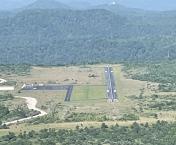
By: Big Orange Bird


