Login
Register


JYO
Leesburg Exec Airport
Official FAA Data Effective 2026-02-19 0901Z
Chart Supplement

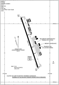
KJYO Airport Diagram
VFR Chart of KJYO
Sectional Charts at SkyVector.com
IFR Chart of KJYO
Enroute Charts at SkyVector.com
Location Information for KJYO
Coordinates: N39°4.68' / W77°33.45'Located 03 miles S of Leesburg, Virginia on 294 acres of land. View all Airports in Virginia.
Surveyed Elevation is 389 feet MSL.
Operations Data
|
|
Airport Communications
| AWOS-3: | 125.225 Tel. 703-777-3781 |
|---|---|
| LEESBURG TOWER TOWER: | 127.5 |
| LEESBURG TOWER GROUND: | 120.5 |
| POTOMAC APPROACH: | 125.05 338.25 |
| POTOMAC DEPARTURE: | 125.05 338.25 |
| CLEARANCE DELIVERY: | 120.5 118.55 ;WHEN JYO TWR CLSD |
| GIBBZ STAR: | 120.45 306.925 |
| PTOMC DP: | 125.05 350.2 |
| CLTCH DP: | 125.05 350.2 |
| COATT STAR: | 128.525 306.925 |
| JDUBB DP: | 125.05 350.2 |
| SCRAM DP: | 125.05 350.2 |
| UNICOM: | 122.975 |
| TRSTN STAR: | 126.75 307.2 |
| CTAF: | 127.500 |
| HYPER STAR: | 133.0 288.35 |
| ASOS at IAD (8.8 S): | 134.85 571-250-7817 |
| D-ATIS at IAD (9.1 SE): | 134.85 |
| AWOS-3PT at GAI (19.0 E): | 128.275 301-977-2971 |
- TWR OPNS CURRENTLY SUPPORTED BY MOBILE/REMOTE ATCT SYS.
Nearby Navigation Aids
|
| ||||||||||||||||||||||||||||||||||||||||||||||||||||||||||||


Runway 17/35
| Dimensions: | 5500 x 100 feet / 1676 x 30 meters | |
|---|---|---|
| Surface: | Asphalt / Grooved in Good Condition | |
| Weight Limits: | 63 /F/A/W/U, S-30, D-70 | |
| Edge Lighting: | High Intensity | |
| Runway 17 | Runway 35 | |
| Coordinates: | N39°5.11' / W77°33.64' | N39°4.25' / W77°33.26' |
| Elevation: | 377.6 | 387.2 |
| Traffic Pattern: | Left | Left |
| Runway Heading: | 161° True | 341° True |
| Markings: | Precision Instrument in good condition. | Non-Precision Instrument in good condition. |
| Glide Slope Indicator | P4L (3.00° Glide Path Angle) | P4L (3.00° Glide Path Angle) |
| Approach Lights: | ODALS Omnidirectional Approach Lighting System NSTD ODALS, 3 LGT CONFIGURATION. | |
| REIL: | Yes | Yes |
| Obstacles: | 30 ft Tree 724 ft from runway, 520 ft left of center | 43 ft Pole 1325 ft from runway, 272 ft right of center |
Services Available
| Fuel: | 100LL (blue), Jet-A |
|---|---|
| Transient Storage: | Hangars,Tiedowns |
| Airframe Repair: | MAJOR |
| Engine Repair: | MAJOR |
| Bottled Oxygen: | LOW |
| Bulk Oxygen: | NONE |
| Other Services: | AIR AMBULANCE SERVICES,CHARTER SERVICE,PILOT INSTRUCTION,AIRCRAFT RENTAL,AIRCRAFT SALES |
Ownership Information
| Ownership: | Publicly owned | |
|---|---|---|
| Owner: | TOWN OF LEESBURG | |
| 25 WEST MARKET ST., 25 WEST MARKET ST. | ||
| LEESBURG, VA 20176 | ||
| 703-777-2420 | ||
| Manager: | SCOTT COFFMAN | |
| 1001 SYCOLIN ROAD, SE, SUITE 7 | ||
| LEESBURG, VA 20175 | ||
| 703-737-7125 | ||
Other Remarks
- RAMP FENCE S/W SIDE RAMPS LEAD IN LINES ON WEST RAMP NA.
- PSBL THERMAL PLUMES FM PWR PLANT 1.3 NM SSE.
- FOR CD WHEN ATCT CLSD, CTC POTOMAC APCH 118.55 OR 866-709-4993.
- BIRDS & DEER ON & INVOF ARPT.
- HEL ACT ON & INVOF ARPT.
- CALM WIND USE RWY 17.
- WHEN ATCT CLSD ACTVT ODALS RWY 17; REIL RWY 17 & 35; PAPI RWY 17 & 35; HIRL RWY 17/35 - CTAF.
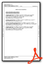
Weather Minimums

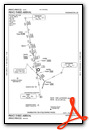
Standard Terminal Arrival (STAR) Charts


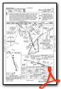
Instrument Approach Procedure (IAP) Charts

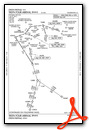
Departure Procedure (DP) Charts


Nearby Airports with Instrument Procedures
| ID | Name | Heading / Distance | ||
|---|---|---|---|---|
 |
KIAD | Washington Dulles International Airport | 149° | 9.1 |
|
KGAI | Montgomery County Airpark Airport | 073° | 19.1 |
|
W50 | Davis Airport | 062° | 21.4 |
|
KHEF | Manassas Regional/Harry P Davis Field Airport | 174° | 21.5 |
|
KFDK | Frederick Municipal Airport | 022° | 22.0 |
|
KOKV | Winchester Regional Airport | 278° | 27.7 |
|
KMRB | Eastern Wv Regional/Shepherd Field Airport | 314° | 27.8 |
|
KDCA | Ronald Reagan Washington Ntl Airport | 119° | 27.9 |
|
KDAA | Davison AAF Airport | 140° | 28.0 |
|
KCGS | College Park Airport | 100° | 30.3 |
|
KHWY | Warrenton/Fauquier Airport | 193° | 30.3 |
|
KFRR | Front Royal-Warren County Airport | 253° | 33.9 |
Fuel Providers

Airport Images

By: Dave


