Login
Register


OKV
Winchester Regional Airport
Official FAA Data Effective 2026-02-19 0901Z
Chart Supplement

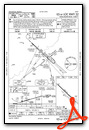
VFR Chart of KOKV
Sectional Charts at SkyVector.com
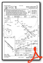
IFR Chart of KOKV
Enroute Charts at SkyVector.com
Location Information for KOKV
Coordinates: N39°8.61' / W78°8.67'Located 03 miles SE of Winchester, Virginia on 375 acres of land. View all Airports in Virginia.
Surveyed Elevation is 726 feet MSL.
TPA 1980 FT AGL FOR TURBOPROP AND JET ACFT; ALL OTHER ACFT TPA 980 FT AGL.
Operations Data
|
|
Airport Communications
| AWOS-3: | 124.85 Tel. 540-662-6970 |
|---|---|
| POTOMAC APPROACH: | 120.45 306.925 |
| POTOMAC DEPARTURE: | 120.45 306.925 |
| CLEARANCE DELIVERY: | 126.15 |
| CTAF: | 122.975 |
| HYPER STAR: | 133.0 288.35 |
| CLTCH DP: | 120.45 306.925 |
| SCRAM DP: | 120.45 306.925 |
| UNICOM: | 122.975 |
| TRSTN STAR: | 126.75 307.2 |
| JDUBB DP: | 120.45 306.925 |
| AWOS-3 at FRR (14.5 S): | 121.85 540-635-5377 |
| ASOS at MRB (17.5 NE): | 119.925 304-264-0988 |
| AWOS-3 at JYO (27.6 E): | 125.225 703-777-3781 |
Nearby Navigation Aids
|
| ||||||||||||||||||||||||||||||||||||||||||||||||||||||||||||


Runway 14/32
| Dimensions: | 5498 x 100 feet / 1676 x 30 meters | |
|---|---|---|
| Surface: | Asphalt / Grooved in Excellent Condition | |
| Weight Limits: | S-75, D-150 | |
| Edge Lighting: | High Intensity | |
| Runway 14 | Runway 32 | |
| Coordinates: | N39°8.92' / W78°9.09' | N39°8.30' / W78°8.25' |
| Elevation: | 726.2 | 700.8 |
| Traffic Pattern: | Left | Left |
| Runway Heading: | 134° True | 314° True |
| Markings: | Non-Precision Instrument in good condition. | Precision Instrument in good condition. |
| Glide Slope Indicator | P4L (3.00° Glide Path Angle) | P4L (3.00° Glide Path Angle) |
| Approach Lights: | MALSR 1,400 Foot Medium-intensity Approach Lighting System with runway alignment indicator lights. | |
| REIL: | Yes | |
| Obstacles: | 27 ft Tree 664 ft from runway, 490 ft left of center | 60 ft Tree 1986 ft from runway, 736 ft left of center |
Services Available
| Fuel: | 100LL (blue), Jet-A |
|---|---|
| Transient Storage: | Hangars,Tiedowns |
| Airframe Repair: | MAJOR |
| Engine Repair: | MAJOR |
| Bottled Oxygen: | NONE |
| Bulk Oxygen: | NONE |
| Other Services: | AIR FREIGHT SERVICES,AVIONICS,CHARTER SERVICE,PILOT INSTRUCTION,AIRCRAFT RENTAL |
Ownership Information
| Ownership: | Publicly owned | |
|---|---|---|
| Owner: | WINCHESTER REG ARPT AUTH | |
| 491 AIRPORT RD | ||
| WINCHESTER, VA 22602 | ||
| 540-662-5786 | ||
| Manager: | NICK SABO | |
| 491 AIRPORT RD | ||
| WINCHESTER, VA 22602 | ||
| 540-662-5786 | ||
Other Remarks
- ADCUS AVBL 24 HRS MIN ADVN NOTICE RQRD CALL 804-661-3660 MON-FRI; AFT HRS AND WKENDS CALL 703-661-3632.
- DEER ON & INVOF ARPT.
- MED-FLIGHT: IREG DEP PAT.
- FOR CD CTC POTOMAC APCH AT 866-709-4993.
- ACTVT MALSR RWY 32; REIL RWY 14; HIRL RWY 14/32 - CTAF.
- TPA 1980 FT AGL FOR TURBOPROP AND JET ACFT; ALL OTHER ACFT TPA 980 FT AGL.
Weather Minimums

Standard Terminal Arrival (STAR) Charts
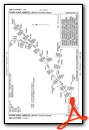


Instrument Approach Procedure (IAP) Charts


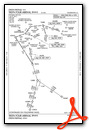
Departure Procedure (DP) Charts

Nearby Airports with Instrument Procedures
| ID | Name | Heading / Distance | ||
|---|---|---|---|---|
 |
KFRR | Front Royal-Warren County Airport | 200° | 14.5 |
|
KMRB | Eastern Wv Regional/Shepherd Field Airport | 025° | 17.2 |
|
KJYO | Leesburg Exec Airport | 097° | 27.7 |
|
W35 | Potomac Airpark Airport | 358° | 32.9 |
|
KLUA | Luray Caverns Airport | 210° | 33.1 |
|
KIAD | Washington Dulles International Airport | 109° | 34.1 |
|
KHEF | Manassas Regional/Harry P Davis Field Airport | 130° | 38.9 |
|
KHGR | Hagerstown Regional/Richard A Henson Field Airport | 029° | 39.0 |
|
KHWY | Warrenton/Fauquier Airport | 148° | 39.1 |
|
KFDK | Frederick Municipal Airport | 065° | 39.4 |
|
8W2 | New Market Airport | 222° | 39.4 |
|
KCJR | Culpeper Regional Airport | 160° | 39.4 |


")


