Login
Register


ACB
Antrim County Airport
Official FAA Data Effective 2025-12-25 0901Z
Chart Supplement

VFR Chart of KACB
Sectional Charts at SkyVector.com
IFR Chart of KACB
Enroute Charts at SkyVector.com
Location Information for KACB
Coordinates: N44°59.31' / W85°11.90'Located 01 miles NE of Bellaire, Michigan on 363 acres of land. View all Airports in Michigan.
Surveyed Elevation is 623 feet MSL.
Operations Data
|
|
Airport Communications
| AWOS-3P: | 119.275 Tel. 231-533-8941 |
|---|---|
| CTAF: | 122.700 |
| UNICOM: | 122.700 |
| AWOS-3PT at BFA (15.8 NE): | 118.675 231-330-8677 |
| AWOS-3P at CVX (19.2 N): | 120.0 231-237-9703 |
| ASOS at GLR (21.1 E): | 118.375 989-732-1571 |
- APCH/DEP SVC PRVDD BY MINNEAPOLIS ARTCC ON 132.9/338.3 (TRAVERSE CITY RCAG).
Nearby Navigation Aids
|
| ||||||||||||||||||||||||||||||||||||||||||||||||||||||||||||


Runway 02/20
| Dimensions: | 5003 x 100 feet / 1525 x 30 meters | |
|---|---|---|
| Surface: | Asphalt / Porous Friction Course in Good Condition | |
| Weight Limits: | S-38, D-55 | |
| Edge Lighting: | Medium Intensity | |
| Runway 02 | Runway 20 | |
| Coordinates: | N44°58.92' / W85°12.07' | N44°59.71' / W85°11.73' |
| Elevation: | 621.6 | 617.5 |
| Traffic Pattern: | Left | Left |
| Runway Heading: | 17° True | 197° True |
| Markings: | Non-Precision Instrument in good condition. | Non-Precision Instrument in good condition. |
| Glide Slope Indicator | P4L (3.00° Glide Path Angle) | P2L (3.25° Glide Path Angle) |
| REIL: | Yes | Yes |
| Obstacles: | 62 ft Tree 1667 ft from runway, 112 ft right of center | |
Services Available
| Fuel: | 100LL (blue), Jet A+ |
|---|---|
| Transient Storage: | Hangars,Tiedowns |
| Airframe Repair: | NOT AVAILABLE |
| Engine Repair: | NOT AVAILABLE |
| Bottled Oxygen: | NOT AVAILABLE |
| Bulk Oxygen: | NOT AVAILABLE |
Ownership Information
| Ownership: | Publicly owned | |
|---|---|---|
| Owner: | ANTRIM COUNTY | |
| PO BOX 520, 230 E CAYUGA ST | ||
| BELLAIRE, MI 49615-0520 | ||
| 231-533-6353 | ||
| Manager: | MATTHEW WYMAN | |
| 3366A S DERENZY RD | ||
| BELLAIRE, MI 49615-9499 | ||
| 231-533-8524 | CELL 231-622-1926. | |
Other Remarks
- LRG BIRDS ON & INVOF ARPT.
- SNOW REMOVAL EQPT ON RWY & TWYS DURG WINTER MONTHS.
- FOR CD CTC MINNEAPOLIS ARTCC AT 651-463-5588.
- 0LL FOR FUEL AFT HRS CALL 231-350-8145.
- ACTVT OR INCR INTST REIL RWY 02 & 20; PAPI RWY 02 & 20; MIRL RWY 02/20 - CTAF. MIRL RWY 02/20 PRESET LOW INTST.
Weather Minimums

Instrument Approach Procedure (IAP) Charts
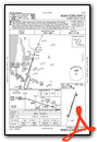
Nearby Airports with Instrument Procedures
| ID | Name | Heading / Distance | ||
|---|---|---|---|---|
 |
KBFA | Boyne Mountain Airport | 047° | 15.8 |
|
N98 | Boyne City Municipal Airport | 033° | 15.9 |
|
KCVX | Charlevoix Municipal Airport | 350° | 19.3 |
|
KGLR | Gaylord Regional Airport | 085° | 21.1 |
|
KTVC | Cherry Capital Airport | 227° | 22.1 |
|
KGOV | Grayling AAF Airport | 132° | 27.3 |
|
KMGN | Harbor Springs Airport | 024° | 28.9 |
|
KPLN | Pellston Regional/Emmet County Airport | 025° | 38.9 |
|
KCAD | Wexford County Airport | 192° | 43.8 |
|
KHTL | Roscommon County/Blodgett Memorial Airport | 148° | 44.0 |
|
KSJX | Beaver Island Airport | 339° | 45.0 |
|
KFKS | Frankfort Dow Memorial Field Airport | 243° | 48.1 |
Airport Images
Do you have a recent image of this airport? Upload it here!


