Login
Register


CBE
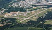
Greater Cumberland Regional Airport
Official FAA Data Effective 2026-01-22 0901Z
Chart Supplement

VFR Chart of KCBE
Sectional Charts at SkyVector.com
IFR Chart of KCBE
Enroute Charts at SkyVector.com
Location Information for KCBE
Coordinates: N39°36.92' / W78°45.69'Located 02 miles S of Cumberland, Maryland on 314 acres of land. View all Airports in Maryland.
Surveyed Elevation is 775 feet MSL.
Operations Data
|
|
Airport Communications
| AWOS-3: | 128.625 Tel. 304-738-0451 |
|---|---|
| JOHNSTOWN APPROACH: | 121.2 299.2 |
| JOHNSTOWN DEPARTURE: | 121.2 299.2 |
| CTAF: | 122.800 |
| UNICOM: | 122.800 |
| AWOS-3 at 2G4 (26.9 W): | 120.125 301-746-8443 |
| AWOS-3P at 2G9 (28.1 NW): | 133.8 814-443-2114 |
| AWOS-3 at HMZ (30.4 N): | 123.675 814-623-2936 |
- APCH/DEP SVC PRVDD BY CLEVELAND ARTCC (ZOB) ON FREQS 124.4/327.1 (ALTOONA RCAG) WHEN JOHNSTOWN APCH CTL CLSD.
Nearby Navigation Aids
|
| ||||||||||||||||||||||||||||||||||||||||||||||||||||||||||||


Runway 05/23
| Dimensions: | 5047 x 150 feet / 1538 x 46 meters | |
|---|---|---|
| Surface: | Asphalt in Fair Condition | |
| Weight Limits: | S-38, D-52 | |
| Edge Lighting: | High Intensity | |
| Runway 05 | Runway 23 | |
| Coordinates: | N39°36.66' / W78°45.89' | N39°37.31' / W78°45.21' |
| Elevation: | 721.9 | 775.0 |
| Traffic Pattern: | Right | Left |
| Runway Heading: | 39° True | 219° True |
| Markings: | Non-Precision Instrument in poor condition. | Precision Instrument in poor condition. |
| Glide Slope Indicator | P4L (3.59° Glide Path Angle) | |
| REIL: | Yes | |
| Obstacles: | 6 ft Trees 308 ft from runway, 5 ft left of center | |
Runway 11/29
| Dimensions: | 3000 x 150 feet / 914 x 46 meters | |
|---|---|---|
| Surface: | Asphalt in Fair Condition | |
| Weight Limits: | S-12 | |
| Edge Lighting: | Low Intensity NSTD LIRL FM RWY 11 THR TO RWY 11 DSPLCD THR, DUE TO IMPROPER LENS COLORS AND SPACING. | |
| Runway 11 | Runway 29 | |
| Coordinates: | N39°36.83' / W78°46.24' | N39°36.77' / W78°45.61' |
| Elevation: | 721.2 | 727.0 |
| Traffic Pattern: | Left | Left |
| Runway Heading: | 97° True | 277° True |
| Displaced Threshold: | 560 Feet | |
| Markings: | Basic in good condition. | Non-Precision Instrument in poor condition. |
| Obstacles: | 336 ft Hill 4187 ft from runway | |
Services Available
| Fuel: | 100LL (blue), Jet-A |
|---|---|
| Transient Storage: | Hangars,Tiedowns |
| Airframe Repair: | NONE |
| Engine Repair: | NONE |
| Bottled Oxygen: | HIGH/LOW BOTTLE OXY AVBL FM 0800-1500 MON-FRI BY PRIOR ARNGMT, CALL 304-738-0002. |
| Bulk Oxygen: | HIGH/LOW BULK OXY AVBL FM 0800-1500 MON-FRI BY PRIOR ARNGMT, CALL 304-738-0002. |
| Other Services: | AIR FREIGHT SERVICES,CARGO HANDLING SERVICES,GLIDER SERVICE,PILOT INSTRUCTION,GLIDER TOWING SERVICES |
Ownership Information
| Ownership: | Publicly owned | |
|---|---|---|
| Owner: | POTOMAC HIGHLAND ARPT AUTH | |
| 165 TERMINAL LOOP | ||
| WILEY FORD, WV 26767 | ||
| 304-738-0002 | ||
| Manager: | HAROLD KELLEY | |
| 165 TERMINAL LOOP | ||
| WILEY FORD, WV 26767 | ||
| 304-738-0002 | ||
Other Remarks
- RWY 11 NGT OPNS & ANY LNDGS NOT RECOMMENDED DUE TO HIGH TERRAIN.
- GLIDER OPNS W OF ARPT USE RWY 11 FOR DEP; RWY 29 FOR ARR.
- DEER/BIRDS ON & INVOF ARPT.
- RWY 23 900 FT TWY ALIGNED WITH RWY WEST END.
- RWY 05 APCH HAS RAPIDLY RISING TERRAIN 696 FT L, 2000 FT FM THR.
- FOR CD CTC JOHNSTOWN APCH AT 814-532-5960, WHEN APCH CLSD CTC CLEVELAND ARTCC AT 440-774-0213.
- COLD TEMPERATURE AIRPORT. ALTITUDE CORRECTION REQUIRED AT OR BELOW -14C.
- FADED
- RWY 05/23 MARKINGS & CL PARTIALLY OBSCURED BY LONGITUDINAL AND TRANSVERSE CRACK FILL. RWY 05/23 MARKINGS FADED.
- FADED
- FADED
- COUNTY LOCATED IN WV.
- ACTVT REIL RWY 23; HIRL RWY 05/23; LIRL RWY 11/29; & TWY LGTS - CTAF.
Weather Minimums

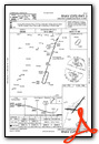
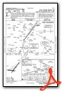
Instrument Approach Procedure (IAP) Charts

Nearby Airports with Instrument Procedures
| ID | Name | Heading / Distance | ||
|---|---|---|---|---|
 |
2G4 | Garrett County Airport | 265° | 26.7 |
|
W35 | Potomac Airpark Airport | 080° | 28.0 |
|
2G9 | Somerset County Airport | 335° | 28.0 |
|
KHMZ | Bedford County Airport | 022° | 30.5 |
|
KMRB | Eastern Wv Regional/Shepherd Field Airport | 109° | 38.3 |
|
KOKV | Winchester Regional Airport | 134° | 40.3 |
|
W99 | Grant County Airport | 205° | 41.3 |
|
KJST | John Murtha Johnstown/Cambria County Airport | 355° | 42.1 |
|
KAOO | Altoona/Blair County Airport | 026° | 45.6 |
|
KVVS | Joseph A Hardy Connellsville Airport | 296° | 46.3 |
|
KFRR | Front Royal-Warren County Airport | 150° | 48.1 |
|
KHGR | Hagerstown Regional/Richard A Henson Field Airport | 083° | 48.3 |
")