Login
Register


W99
Grant County Airport
Official FAA Data Effective 2026-01-22 0901Z
Chart Supplement

VFR Chart of W99
Sectional Charts at SkyVector.com
IFR Chart of W99
Enroute Charts at SkyVector.com
Location Information for W99
Coordinates: N38°59.70' / W79°8.75'Located 01 miles SW of Petersburg, West Virginia on 188 acres of land. View all Airports in West Virginia.
Surveyed Elevation is 962 feet MSL.
Operations Data
|
|
Airport Communications
| AWOS-3: | 124.475 Tel. 304-257-2477 |
|---|---|
| CTAF: | 122.800 |
| UNICOM: | 122.800 |
| AWOS-3 at 8W2 (28.9 SE): | 118.175 540-740-3801 |
| ASOS at EKN (33.8 W): | 119.275 304-591-9020 |
| AWOS-3 at LUA (36.0 SE): | 118.275 540-743-1148 |
- APCH/DEP SVC PRVDD BY WASHINGTON ARTCC ON FREQS 133.55/322.55 (LINDEN RCAG).
Nearby Navigation Aids
|
| ||||||||||||||||||||||||||||||||||||||||||||||||||||||||||||


Runway 13/31
| Dimensions: | 5000 x 75 feet / 1524 x 23 meters | |
|---|---|---|
| Surface: | Asphalt in Good Condition | |
| Weight Limits: | S-41, D-53 | |
| Edge Lighting: | Medium Intensity | |
| Runway 13 | Runway 31 | |
| Coordinates: | N38°59.92' / W79°9.20' | N38°59.48' / W79°8.31' |
| Elevation: | 962.9 | 947.8 |
| Traffic Pattern: | Left | Right RIGHT TRAFFIC FOR GLIDER AND ULTRA-LIGHT ONLY. ALL OTHER POWERED AIRCRAFT STANDARD LEFT TRAFFIC PATTERN. |
| Runway Heading: | 122° True | 302° True |
| Markings: | Basic in fair condition. | Non-Precision Instrument in fair condition. |
| Glide Slope Indicator | P4L (6.50° Glide Path Angle) | |
| REIL: | Yes | Yes |
| Obstacles: | 6 ft Fence 201 ft from runway, 250 ft left of center | 6 ft Fence 305 ft from runway, 255 ft left of center |
Services Available
| Fuel: | 100LL (blue), Jet-A |
|---|---|
| Transient Storage: | Hangars,Tiedowns OVNGT TIEDOWN FEE WAIVED WITH FUEL PURCHASE. |
| Airframe Repair: | MAJOR |
| Engine Repair: | MAJOR |
| Bottled Oxygen: | NOT AVAILABLE |
| Bulk Oxygen: | NONE |
Ownership Information
| Ownership: | Publicly owned | |
|---|---|---|
| Owner: | GRANT COUNTY AIRPORT AUTH | |
| 5 HIGHLAND AVE | ||
| PETERSBURG, WV 26847 | ||
| 304-257-4435 | ||
| Manager: | TOM FEASTER | |
| 440 AIRPORT RD | ||
| PETERSBURG, WV 26802 | ||
| 304-257-4435 | ||
Other Remarks
- BIRDS ON & INVOF ARPT.
- FLY-IN CAMPGROUND ON ARPT.
- COLD TEMPERATURE AIRPORT. ALTITUDE CORRECTION REQUIRED AT OR BELOW -7C.
- FOR CD CTC WASHINGTON ARTCC AT 703-771-3587.
- 0LL SELF SVC FUEL 24/7.
- ACTVT REIL RWY 13 & 31; PAPI RWY 31; MIRL RWY 13/31 - CTAF.
Weather Minimums

Instrument Approach Procedure (IAP) Charts


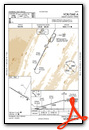
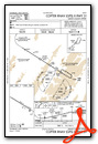
Nearby Airports with Instrument Procedures
| ID | Name | Heading / Distance | ||
|---|---|---|---|---|
 |
8W2 | New Market Airport | 134° | 28.9 |
|
KEKN | Elkins/Randolph County (Jennings Randolph Field) Airport | 259° | 33.9 |
|
KLUA | Luray Caverns Airport | 122° | 36.1 |
|
2G4 | Garrett County Airport | 345° | 36.2 |
|
KVBW | Bridgewater Air Park Airport | 166° | 38.7 |
|
KCBE | Greater Cumberland Regional Airport | 025° | 41.3 |
|
KFRR | Front Royal-Warren County Airport | 096° | 42.0 |
|
79D | Philippi/Barbour County Regional Airport | 283° | 44.0 |
|
KSHD | Shenandoah Valley Regional Airport | 164° | 45.4 |
|
KOKV | Winchester Regional Airport | 078° | 47.6 |
|
W22 | Upshur County Regional Airport | 270° | 52.8 |
|
KMGW | Morgantown Municipal/Walter L Bill Hart Field Airport | 317° | 52.9 |
Airport Images

By: Big Orange Bird


Comments
W99 - Grant County Airport
W99 - Grant County Airport provides essential air services to the local community and serves as a vital link for regional transportation. With its well-maintained facilities and dedicated staff, it ensures safe and efficient operations for both commercial and private aviation. Its strategic location enhances connectivity and fosters economic development in the region. A commendable asset for Grant County and beyond.