Login
Register


CVX
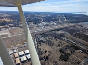
Charlevoix Municipal Airport
Official FAA Data Effective 2026-02-19 0901Z
Chart Supplement

VFR Chart of KCVX
Sectional Charts at SkyVector.com
IFR Chart of KCVX
Enroute Charts at SkyVector.com
Location Information for KCVX
Coordinates: N45°18.29' / W85°16.52'Located 01 miles SW of Charlevoix, Michigan on 185 acres of land. View all Airports in Michigan.
Surveyed Elevation is 668 feet MSL.
Operations Data
|
|
Airport Communications
| AWOS-3P: | 120.0 Tel. 231-237-9703 |
|---|---|
| UNICOM: | 122.800 |
| CTAF: | 122.800 |
| AWOS-3P at MGN (16.9 NE): | 119.925 231-347-5231 |
| AWOS-3PT at BFA (17.1 SE): | 118.675 231-330-8677 |
| AWOS-3P at ACB (19.4 S): | 119.275 231-533-8941 |
- APCH/DEP SVC PRVDD BY MINNEAPOLIS ARTCC ON FREQS 134.6/354.05 (PELLSTON RCAG).
Nearby Navigation Aids
|
| ||||||||||||||||||||||||||||||||||||||||||||||||||||||||||||


Runway 09/27
| Dimensions: | 4549 x 75 feet / 1387 x 23 meters | |
|---|---|---|
| Surface: | Asphalt in Good Condition | |
| Weight Limits: | S-12 | |
| Edge Lighting: | Non-Standard NSTD MIRL DUE TO RWY 27 THR LGTS LCTD OUTBOARD FM RWY EDGES. | |
| Runway 09 | Runway 27 | |
| Coordinates: | N45°18.25' / W85°17.15' | N45°18.32' / W85°16.09' |
| Elevation: | 668.8 | 643.1 |
| Runway Heading: | 85° True | 265° True |
| Markings: | Non-Precision Instrument in good condition. | Non-Precision Instrument in good condition. |
| Glide Slope Indicator | P4R (3.00° Glide Path Angle) | P4R (3.00° Glide Path Angle) |
| REIL: | Yes | Yes |
| Obstacles: | 56 ft Tree 1231 ft from runway, 322 ft right of center | |
Runway 04/22
CLSD NOV-APR. | ||
| Dimensions: | 1280 x 200 feet / 390 x 61 meters | |
|---|---|---|
| Surface: | Turf in Good Condition | |
| Runway 04 | Runway 22 | |
| Coordinates: | N45°18.23' / W85°16.25' | N45°18.39' / W85°16.06' |
| Elevation: | 646.0 | 640.2 |
| Traffic Pattern: | Left | Left |
| Runway Heading: | 40° True | 220° True |
| Obstacles: | 100 ft Trees 2000 ft from runway | 95 ft Tree 1900 ft from runway |
Services Available
| Fuel: | 100LL (blue), Jet A+ |
|---|---|
| Transient Storage: | Tiedowns |
| Airframe Repair: | MAJOR |
| Engine Repair: | MAJOR |
| Bottled Oxygen: | NOT AVAILABLE |
| Bulk Oxygen: | NOT AVAILABLE |
| Other Services: | CHARTER SERVICE,PARACHUTE JUMP ACTIVITY |
Ownership Information
| Ownership: | Publicly owned | |
|---|---|---|
| Owner: | CITY OF CHARLEVOIX | |
| 210 STATE ST | ||
| CHARLEVOIX, MI 49720-1345 | ||
| 231-547-3270 | ||
| Manager: | ROBERT SCHOLEY | |
| 111 AIRPORT DR | ||
| CHARLEVOIX, MI 49720-8904 | ||
| 231-547-3605 | ||
Other Remarks
- RWY 09/27 UPSLP FM EAST TO WEST, STEEPEST GRAD OCRS WEST THIRD OF RWY.
- FOR CD CTC MINNEAPOLIS ARTCC AT 651-463-5588.
- DEER & BIRDS ON & INVOF ARPT.
- -100 FT QUARRY/MINE, 300 FT FM RWY 09 THR.
- CHARLEVOIX VOLUNTARY QUIET HRS WEF 2300-0700 DLY.
- PREFERRED LDG RWY 2300-0700.
- PREFERRED TKOF RWY 2300-0700.
- 3 FT YELLOW CONES.
- 3 FT YELLOW CONES.
- 0LL FOR FUEL AFT HRS CALL AMGR.
- ACTVT REIL RWY 09 & 27; PAPI RWY 09 & 27; NSTD MIRL RWY 09/27 - CTAF.
Weather Minimums


Instrument Approach Procedure (IAP) Charts


Nearby Airports with Instrument Procedures
| ID | Name | Heading / Distance | ||
|---|---|---|---|---|
 |
N98 | Boyne City Municipal Airport | 115° | 13.4 |
|
KMGN | Harbor Springs Airport | 064° | 16.9 |
|
KBFA | Boyne Mountain Airport | 119° | 17.1 |
|
KACB | Antrim County Airport | 170° | 19.3 |
|
KPLN | Pellston Regional/Emmet County Airport | 051° | 25.8 |
|
KSJX | Beaver Island Airport | 332° | 26.3 |
|
KGLR | Gaylord Regional Airport | 125° | 29.9 |
|
KTVC | Cherry Capital Airport | 201° | 36.2 |
|
KSLH | Cheboygan County Airport | 056° | 38.2 |
|
83D | Mackinac County Airport | 032° | 41.8 |
|
6Y1 | Bois Blanc Island Airport | 049° | 42.7 |
|
KMCD | Mackinac Island Airport | 038° | 43.0 |
Airport Images
By: potatohead


