Login
Register
DAN
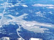
Danville Regional Airport
Official FAA Data Effective 2026-01-22 0901Z
VFR Chart of KDAN
Sectional Charts at SkyVector.com
IFR Chart of KDAN
Enroute Charts at SkyVector.com
Location Information for KDAN
Coordinates: N36°34.35' / W79°20.18'Located 03 miles E of Danville, Virginia on 800 acres of land. View all Airports in Virginia.
Surveyed Elevation is 571 feet MSL.
TPA 800 FT AGL LGT ACFT; 1500 FT AGL TURBINE ACFT.
Operations Data
|
|
Airport Communications
| ASOS: | 128.125 Tel. 434-799-1701 |
|---|---|
| UNICOM: | 123.050 |
| CTAF: | 123.050 |
| AWOS-3 at TDF (24.2 SE): | 126.725 336-364-1651 |
| AWOS-3 at W78 (25.0 E): | 119.425 434-575-0332 |
| AWOS-3 at SIF (26.2 W): | 119.775 336-573-3677 |
- APCH/DEP SVC PRVDD BY WASHINGTON ARTCC ON FREQS 124.05/352.0 (SOUTH BOSTON RCAG).
Nearby Navigation Aids
|
| ||||||||||||||||||||||||||||||||||||||||||||||||||||||||||||
Runway 02/20
| Dimensions: | 5900 x 100 feet / 1798 x 30 meters | |
|---|---|---|
| Surface: | Asphalt / Grooved in Good Condition | |
| Weight Limits: | S-90, D-130 | |
| Edge Lighting: | High Intensity | |
| Runway 02 | Runway 20 | |
| Coordinates: | N36°33.78' / W79°20.49' | N36°34.71' / W79°20.15' |
| Elevation: | 535.6 | 564.6 |
| Traffic Pattern: | Left | Left |
| Runway Heading: | 16° True | 196° True |
| Displaced Threshold: | 300 Feet | |
| Declared Distances: | TORA:5600 TODA:5900 ASDA:5600 LDA:5600 | TORA:5900 TODA:5900 ASDA:5900 LDA:5600 |
| Markings: | Precision Instrument in good condition. | Non-Precision Instrument in good condition. |
| Glide Slope Indicator | P4L (3.00° Glide Path Angle) | P4L (3.00° Glide Path Angle) |
| Approach Lights: | MALSR 1,400 Foot Medium-intensity Approach Lighting System with runway alignment indicator lights. | |
| REIL: | Yes | |
| Obstacles: | 53 ft Tree 2255 ft from runway, 750 ft left of center | 129 ft Tree 4436 ft from runway, 552 ft right of center SLP TO DTHR 39:1. |
Runway 13/31
| Dimensions: | 3910 x 100 feet / 1192 x 30 meters | |
|---|---|---|
| Surface: | Asphalt in Good Condition | |
| Weight Limits: | S-90, D-130 | |
| Edge Lighting: | Medium Intensity | |
| Runway 13 | Runway 31 | |
| Coordinates: | N36°34.69' / W79°20.28' | N36°34.33' / W79°19.63' |
| Elevation: | 571.1 | 527.8 |
| Traffic Pattern: | Left | Left |
| Runway Heading: | 125° True | 305° True |
| Markings: | Basic in good condition. | Non-Precision Instrument in good condition. |
| Glide Slope Indicator | V2L (3.00° Glide Path Angle) | P2L (4.00° Glide Path Angle) |
| REIL: | Yes | Yes |
| Obstacles: | 120 ft Tree 2708 ft from runway, 429 ft left of center | 19 ft Trees 464 ft from runway, 61 ft left of center |
Services Available
| Fuel: | 100LL (blue), Jet A+ |
|---|---|
| Transient Storage: | Hangars,Tiedowns |
| Airframe Repair: | MAJOR |
| Engine Repair: | MAJOR |
| Bottled Oxygen: | NONE |
| Bulk Oxygen: | NONE |
| Other Services: | PILOT INSTRUCTION,AIRCRAFT RENTAL |
Ownership Information
| Ownership: | Publicly owned | |
|---|---|---|
| Owner: | CITY OF DANVILLE | |
| PO BOX 3300 | ||
| DANVILLE, VA 24543 | ||
| 434-799-5110 | ||
| Manager: | MARC ADELMAN | |
| 424 AIRPORT DRIVE | ||
| DANVILLE, VA 24540 | ||
| 434-799-5110 | ||
Other Remarks
- BIRDS & DEER ON & INVOF ARPT.
- RY 02 IS DESIGNATED CALM WIND RY.
- CTC ARPT ADMIN PRIOR TO CONDUCTING SPECIALIZED AERO ACTIVITIES 434-799-5110.
- TREES PENETRATING 7:1 TRANSITIONAL SURFACE, RY 31 BOTH SIDES, FIRST 1000 FT.
- FOR CD IF UNA TO CTC ON FSS FREQ, CTC WASHINGTON ARTCC AT 703-771-3587.
- ACTVT HIRL RY 02/20, MIRL RY 13/31, REIL RYS 13, 31, & 20, MALSR RY 02, VASI RY 13, & PAPIS RYS 02, 20, & 31 - CTAF.
- TPA 800 FT AGL LGT ACFT; 1500 FT AGL TURBINE ACFT.
Weather Minimums
Instrument Approach Procedure (IAP) Charts
Nearby Airports with Instrument Procedures
| ID | Name | Heading / Distance | ||
|---|---|---|---|---|
 |
KTDF | Raleigh Regional At Person County Airport | 135° | 24.2 |
 |
W78 | William M Tuck Airport | 070° | 24.9 |
 |
KSIF | Rockingham County Nc Shiloh Airport | 252° | 26.2 |
 |
KBUY | Burlington/Alamance Regional Airport | 191° | 32.0 |
 |
KMTV | Blue Ridge Airport | 276° | 33.1 |
 |
W91 | Smith Mountain Lake Airport | 339° | 34.4 |
 |
W63 | Lake Country Regional Airport | 087° | 37.6 |
 |
0V4 | Brookneal/Campbell County Airport | 024° | 37.4 |
 |
KGSO | Piedmont Triad International Airport | 226° | 40.7 |
 |
KHNZ | Henderson/Oxford Airport | 107° | 41.0 |
 |
W90 | New London Airport | 000° | 41.9 |
 |
KCXE | Chase City Municipal Airport | 071° | 42.3 |


Comments
Kinda pricey
I left a nice review on airnav and the next time I stopped in I bought a quart of oil. $10. For oil. In Danville Virgina. Then they stole $20 from me and labeled it a 'ramp fee' when I was holed up due to a snow storm. That is on top of the fuel service fuel that I purchased of course.