Login
Register


DLC
Dillon County Airport
Official FAA Data Effective 2026-01-22 0901Z
Chart Supplement

VFR Chart of KDLC
Sectional Charts at SkyVector.com
IFR Chart of KDLC
Enroute Charts at SkyVector.com
Location Information for KDLC
Coordinates: N34°26.94' / W79°22.11'Located 03 miles N of Dillon, South Carolina on 32 acres of land. View all Airports in South Carolina.
Surveyed Elevation is 133 feet MSL.
Operations Data
|
|
Airport Communications
| FLORENCE APPROACH: | 118.6 341.7 |
|---|---|
| FLORENCE DEPARTURE: | 118.6 341.7 |
| CTAF: | 122.900 |
| AWOS-3PT at MAO (15.9 S): | 119.875 843-423-4231 |
| ASOS at LBT (18.0 NE): | 134.775 910-739-7120 |
| ASOS at MEB (20.5 N): | 134.125 910-844-5338 |
- APCH/DEP SVC PRVDD BY JACKSONVILLE ARTCC ON FREQS 133.45/306.3 (FLORENCE RCAG) WHEN FLORENCE APCH CTL CLSD.
Nearby Navigation Aids
|
| ||||||||||||||||||||||||||||||||||||||||||||||||||||||||||||


Runway 07/25
| Dimensions: | 3000 x 60 feet / 914 x 18 meters | |
|---|---|---|
| Surface: | Asphalt / Aggregate Friction Seal Coated in Fair Condition | |
| Weight Limits: | S-10 | |
| Edge Lighting: | Medium Intensity | |
| Runway 07 | Runway 25 | |
| Coordinates: | N34°26.83' / W79°22.38' | N34°27.05' / W79°21.85' |
| Elevation: | 133.1 | 117.3 |
| Traffic Pattern: | Left | Left |
| Runway Heading: | 64° True | 244° True |
| Markings: | Non-Precision Instrument in good condition. | Non-Precision Instrument in good condition. |
| Obstacles: | 44 ft Pole 773 ft from runway, 258 ft right of center | 52 ft Tree 302 ft from runway, 135 ft left of center RWY 25 APCH HAS LINES OF TREES PARL TO THE RWY 135 FT BOTH SIDES OF CNTRLN. |
Services Available
| Fuel: | NONE |
|---|---|
| Transient Storage: | Tiedowns |
| Airframe Repair: | NONE |
| Engine Repair: | NONE |
| Bottled Oxygen: | NONE |
| Bulk Oxygen: | NONE |
Ownership Information
| Ownership: | Publicly owned | |
|---|---|---|
| Owner: | DILLON COUNTY | |
| PO BOX 449 | ||
| DILLON, SC 29536 | ||
| (843) 774-1401 | ||
| Manager: | TIM HARPER | |
| PO BOX 449 | ||
| DILLON, SC 29536 | ||
| 843-845-8529 | ||
Other Remarks
- THIS AIRPORT HAS BEEN SURVEYED BY THE NATIONAL GEODETIC SURVEY.
- FOR CD CTC FLORENCE APCH AT 843-665-0632, WHEN APCH CLSD CTC JACKSONVILLE ARTCC AT 904-845-1592.
Weather Minimums

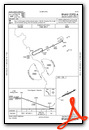
Instrument Approach Procedure (IAP) Charts
Nearby Airports with Instrument Procedures
| ID | Name | Heading / Distance | ||
|---|---|---|---|---|
 |
KMAO | Marion County Airport | 174° | 16.1 |
|
KLBT | Lumberton Regional Airport | 057° | 18.1 |
|
KMEB | Laurinburg/Maxton Airport | 000° | 20.6 |
|
KBBP | Marlboro County Jetport/H E Avent Field Airport | 299° | 20.9 |
|
KFLO | Florence Regional Airport | 228° | 23.7 |
|
KUDG | Darlington County Airport | 269° | 25.7 |
|
KRCZ | Richmond County Airport | 323° | 32.8 |
|
5J9 | Twin City Airport | 130° | 33.1 |
|
KCQW | Cheraw Municipal/Lynch Bellinger Field Airport | 298° | 33.2 |
|
KCPC | Columbus County Regional Airport | 107° | 34.1 |
|
5W4 | P K Airpark Airport | 014° | 35.3 |
|
KHVS | Hartsville Regional Airport | 265° | 37.4 |
Airport Images
Do you have a recent image of this airport? Upload it here!


