Login
Register


EVW
Evanston-Uinta County Burns Field Airport
Official FAA Data Effective 2026-02-19 0901Z
Chart Supplement

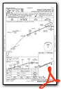
VFR Chart of KEVW
Sectional Charts at SkyVector.com
IFR Chart of KEVW
Enroute Charts at SkyVector.com
Location Information for KEVW
Coordinates: N41°16.49' / W111°2.08'Located 03 miles W of Evanston, Wyoming on 545 acres of land. View all Airports in Wyoming.
Surveyed Elevation is 7142 feet MSL.
Operations Data
|
|
Airport Communications
| ASOS: | 120.0 Tel. 307-789-0585 |
|---|---|
| CTAF: | 123.000 |
| UNICOM: | 123.000 |
| AWOS-3PT at FBR (29.2 E): | 118.8 307-782-3226 |
| AWOS-3PT at EMM (39.3 NE): | 119.675 307-877-9838 |
| ATIS at HIF (43.4 W): | 134.925 |
- APCH/DEP CTL SVC PRVDD BY SALT LAKE ARTCC ( ZLC) ON FREQS 127.7/354.125 (FRANCIS PEAK RCAG).
Nearby Navigation Aids
|
| ||||||||||||||||||||||||||||||||||||


Runway 05/23
| Dimensions: | 7300 x 100 feet / 2225 x 30 meters | |
|---|---|---|
| Surface: | Asphalt / Grooved in Good Condition | |
| Weight Limits: | S-73, D-93, ST-148
PCR VALUE: 295/F/D/X/T
| |
| Edge Lighting: | High Intensity | |
| Runway 05 | Runway 23 | |
| Coordinates: | N41°16.25' / W111°2.81' | N41°16.72' / W111°1.35' |
| Elevation: | 7135.1 | 7136.4 |
| Runway Heading: | 66° True | 246° True |
| Markings: | Precision Instrument in good condition. | Precision Instrument in good condition. |
| Glide Slope Indicator | P4L (3.00° Glide Path Angle) | P4L (3.00° Glide Path Angle) |
| Approach Lights: | MALSR 1,400 Foot Medium-intensity Approach Lighting System with runway alignment indicator lights. | |
| REIL: | Yes | |
Services Available
| Fuel: | 100LL (blue), Jet-A |
|---|---|
| Transient Storage: | Hangars,Tiedowns ARPT CHRGS FAC FEE. |
| Airframe Repair: | MAJOR |
| Engine Repair: | MAJOR |
| Bottled Oxygen: | NONE |
| Bulk Oxygen: | LOW |
Ownership Information
| Ownership: | Publicly owned | |
|---|---|---|
| Owner: | CITY OF EVANSTON | COUNTY OF UINTA. |
| 1200 MAIN ST | ||
| EVANSTON, WY 82930 | ||
| (307) 783-0318 | ||
| Manager: | MIKE LASALLE | |
| PO BOX 756 | ||
| EVANSTON, WY 82931 | ||
| 307-789-2256 | ||
Other Remarks
- GCO AVBL ON FREQ 121.72 THRU SALT LAKE ARTCC CD, CASPER FSS NOT AVBL.
- FOR CD IF UNA VIA GCO CTC SALT LAKE ARTCC AT 801-320-2568.
- ACTVT MALSR RWY 23; REIL RWY 05; HIRL RWY 05/23 - CTAF. RWY 05/23 PAPIS ON CONSLY.
Weather Minimums


Instrument Approach Procedure (IAP) Charts


Departure Procedure Obstacles (DPO) Charts

Nearby Airports with Instrument Procedures
| ID | Name | Heading / Distance | ||
|---|---|---|---|---|
 |
KFBR | Fort Bridger Airport | 075° | 29.3 |
|
KEMM | Kemmerer Municipal Airport | 032° | 39.3 |
|
KHIF | Hill AFB Airport | 258° | 43.5 |
|
KOGD | Ogden-Hinckley Airport | 264° | 44.5 |
|
KLGU | Logan-Cache Airport | 310° | 48.1 |
|
KBMC | Brigham City Regional Airport | 290° | 49.3 |
|
KHCR | Heber Valley Airport | 200° | 50.8 |
|
KSLC | Salt Lake City International Airport | 236° | 51.8 |
|
1U7 | Bear Lake County Airport | 346° | 60.1 |
|
KPVU | Provo Municipal Airport | 206° | 70.7 |
|
KTVY | Bolinder Field/Tooele Valley Airport | 236° | 71.8 |
|
KSPK | Spanish Fork Municipal/Woodhouse Field Airport | 203° | 73.6 |
Fuel Providers

Airport Images

By: bdaa86@gmail.com

By: bdaa86@gmail.com
- 1 of 2
- next ›


