Login
Register


SPK
Spanish Fork Municipal/Woodhouse Field Airport
Official FAA Data Effective 2025-11-27 0901Z
Chart Supplement

VFR Chart of KSPK
Sectional Charts at SkyVector.com
IFR Chart of KSPK
Enroute Charts at SkyVector.com
Location Information for KSPK
Coordinates: N40°8.70' / W111°40.06'Located 02 miles N of Spanish Fork, Utah on 345 acres of land. View all Airports in Utah.
Estimated Elevation is 4529 feet MSL.
TPA FOR FIXED WING ACFT IS 1000 FT AGL; TPA FOR ROTARY WING ACFT IS 500 FT AGL.
Operations Data
|
|
Airport Communications
| AWOS-3PT: | 119.275 Tel. 801-804-5801 |
|---|---|
| SALT LAKE CITY APPROACH: | 118.85 233.7 |
| SALT LAKE CITY DEPARTURE: | 118.85 233.7 |
| CTAF: | 122.900 |
| ATIS at PVU (5.1 NW): | 135.175 |
| AWOS-3PT at PVU (5.4 NW): | 135.175 801-373-9782 |
| AWOS-3PT at HCR (22.7 NE): | 124.825 435-657-0892 |
Nearby Navigation Aids
|
| ||||||||||||||||||||||||||||||||||||


Runway 12/30
| Dimensions: | 6500 x 100 feet / 1981 x 30 meters | |
|---|---|---|
| Surface: | Asphalt in Good Condition | |
| Weight Limits: | 17 /F/D/X/T, S-24, D-36 | |
| Edge Lighting: | Medium Intensity | |
| Runway 12 | Runway 30 | |
| Coordinates: | N40°9.06' / W111°40.58' | N40°8.34' / W111°39.55' |
| Elevation: | 4523.9 | 4528.8 |
| Runway Heading: | 132° True | 312° True |
| Markings: | Non-Precision Instrument in poor condition. | Non-Precision Instrument in poor condition. |
| Glide Slope Indicator | P4L (3.00° Glide Path Angle) | P4L (3.00° Glide Path Angle) |
| REIL: | Yes | Yes |
| Obstacles: | 16 ft Road 350 ft from runway | |
Services Available
| Fuel: | 100LL (blue), Jet-A |
|---|---|
| Transient Storage: | Hangars,Tiedowns |
| Airframe Repair: | MAJOR |
| Engine Repair: | MAJOR |
| Bottled Oxygen: | NONE |
| Bulk Oxygen: | NONE |
| Other Services: | AVIONICS,PILOT INSTRUCTION,AIRCRAFT RENTAL |
Ownership Information
| Ownership: | Publicly owned | |
|---|---|---|
| Owner: | SPANISH FORK | |
| 2050 NORTH 300 WEST | ||
| SPANISH FORK, UT 84660 | ||
| 801-798-5000 | ||
| Manager: | CHRISTIAN DAVIS | |
| 2050 NORTH 300 WEST | ||
| SPANISH FORK, UT 84660 | ||
| 801-804-4593 | ||
Other Remarks
- FOR CD CTC SALT LAKE CITY APCH AT 801-325-9670.
- COLD TEMPERATURE AIRPORT. ALTITUDE CORRECTION REQUIRED AT OR BELOW -17C.
- RWY 12 APCH, 60 FT MKD/LGTD PLINE, 1475 FT DSTC, 0 FT BOTH, APCH SLOPE 21:1.
- LNDG FEES IN EFCT FOR ALL ACFT.
- 0LL SELF SVC 100LL AVBL 24 HRS.
- FOR JET A FUEL CALL 801-798-9888.
- ACTVT REIL RWY 12 & 30; PAPI RWY 12 & 30; MIRL RWY 12/30 - CTAF.
- TPA FOR FIXED WING ACFT IS 1000 FT AGL; TPA FOR ROTARY WING ACFT IS 500 FT AGL.
Weather Minimums

Standard Terminal Arrival (STAR) Charts
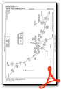

Instrument Approach Procedure (IAP) Charts
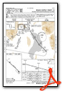
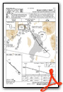
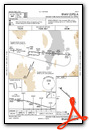
Departure Procedure Obstacles (DPO) Charts


Nearby Airports with Instrument Procedures
| ID | Name | Heading / Distance | ||
|---|---|---|---|---|
 |
KPVU | Provo Municipal Airport | 330° | 5.1 |
|
KHCR | Heber Valley Airport | 028° | 23.0 |
|
U14 | Nephi Municipal Airport | 200° | 26.2 |
|
KSVR | South Valley Regional Airport | 332° | 32.1 |
|
KSLC | Salt Lake City International Airport | 339° | 41.1 |
|
KTVY | Bolinder Field/Tooele Valley Airport | 312° | 42.0 |
|
41U | Manti-Ephraim Airport | 176° | 48.8 |
|
KPUC | Carbon County Regional/Buck Davis Field Airport | 126° | 53.0 |
|
69V | Huntington Municipal Airport | 143° | 58.4 |
|
KDTA | Delta Municipal Airport | 220° | 59.8 |
|
KHIF | Hill AFB Airport | 346° | 60.3 |
|
KOGD | Ogden-Hinckley Airport | 346° | 64.9 |
Fuel Providers

Airport Images
Do you have a recent image of this airport? Upload it here!


