Login
Register


PVU
Provo Municipal Airport
Official FAA Data Effective 2026-02-19 0901Z
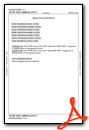
Chart Supplement

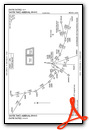
KPVU Airport Diagram

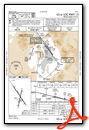
VFR Chart of KPVU
Sectional Charts at SkyVector.com
IFR Chart of KPVU
Enroute Charts at SkyVector.com
Location Information for KPVU
Coordinates: N40°13.15' / W111°43.40'Located 02 miles SW of Provo, Utah on 869 acres of land. View all Airports in Utah.
Surveyed Elevation is 4496 feet MSL.
Operations Data
|
|
Airport Communications
| ATIS: | 135.175 |
|---|---|
| AWOS-3PT: | 135.175 Tel. 801-373-9782 |
| PROVO TOWER: | 125.3 |
| PROVO GROUND: | 119.4 |
| SALT LAKE CITY APPROACH: | 118.85 233.7 |
| SALT LAKE CITY DEPARTURE: | 118.85 233.7 |
| CTAF: | 125.300 |
| AWOS-3PT at SPK (4.7 SE): | 119.275 801-804-5801 |
| AWOS-3PT at HCR (20.4 NE): | 124.825 435-657-0892 |
| AWOS-3PT at SVR (27.0 NW): | 134.425 801-562-0271 |
- PRIM RADAR NOT AVBL. RADAR TFC ADVISORIES AND SVCS AVBL FOR TRANSPONDER EQUIPPED ACFT ONLY.
Nearby Navigation Aids
|
| ||||||||||||||||||||||||||||||||||||


Runway 13/31
| Dimensions: | 8603 x 150 feet / 2622 x 46 meters | |
|---|---|---|
| Surface: | Asphalt / Grooved in Good Condition | |
| Weight Limits: | S-65, D-85, ST-140
PCR VALUE: 534/F/D/X/T
| |
| Edge Lighting: | High Intensity | |
| Runway 13 | Runway 31 | |
| Coordinates: | N40°13.81' / W111°43.95' | N40°12.64' / W111°42.91' |
| Elevation: | 4496.9 | 4492.7 |
| Traffic Pattern: | Right | Left |
| Runway Heading: | 146° True | 326° True |
| Declared Distances: | TORA:8599 TODA:8599 ASDA:8599 LDA:8599 | TORA:8599 TODA:8599 ASDA:8599 LDA:8599 |
| Markings: | Precision Instrument in good condition. | Non-Precision Instrument in good condition. |
| Glide Slope Indicator | P4L (3.00° Glide Path Angle) | P2L (3.00° Glide Path Angle) |
| REIL: | Yes | |
Runway 18/36
| Dimensions: | 6628 x 150 feet / 2020 x 46 meters | |
|---|---|---|
| Surface: | Asphalt in Good Condition | |
| Weight Limits: | S-50, D-70, ST-110 | |
| Edge Lighting: | Medium Intensity | |
| Runway 18 | Runway 36 | |
| Coordinates: | N40°13.59' / W111°43.22' | N40°12.52' / W111°43.51' |
| Elevation: | 4493.7 | 4492.6 |
| Traffic Pattern: | Right | Left |
| Runway Heading: | 192° True | 12° True |
| Declared Distances: | TORA:6614 TODA:6614 ASDA:6614 LDA:6614 | TORA:6614 TODA:6614 ASDA:6614 LDA:6614 |
| Markings: | Basic in good condition. | Basic in good condition. |
| Glide Slope Indicator | P2L (3.00° Glide Path Angle) | P2L (3.00° Glide Path Angle) |
Services Available
| Fuel: | 100 (green), Jet-A |
|---|---|
| Transient Storage: | Hangars,Tiedowns |
| Airframe Repair: | MAJOR |
| Engine Repair: | MAJOR |
| Bottled Oxygen: | LOW |
| Bulk Oxygen: | LOW |
| Other Services: | AIR AMBULANCE SERVICES,CHARTER SERVICE,PILOT INSTRUCTION,AIRCRAFT RENTAL,ANNUAL SURVEYING |
Ownership Information
| Ownership: | Publicly owned | |
|---|---|---|
| Owner: | CITY OF PROVO | |
| 1377 S. 350 E. | ||
| PROVO, UT 84606 | ||
| 801-852-6715 | ||
| Manager: | BRIAN TORGERSEN | |
| P. O. BOX 1849 | ||
| PROVO, UT 84603 | ||
| 801-852-6720 | ||
Other Remarks
- BE ALERT; HELICOPTERS ARRIVING & DEPARTING FM RYS & TAXIWAYS.
- EXTNSV FLT TRNG INVOF ARPT.
- USE CAUTION FOR EXTENSIVE PARAGLIDING OPS INVOF POINT OF THE MOUNTAIN.
- FOR CD WHEN ATCT IS CLSD CTC SLC APCH AT 801-325-9670.
- 24 HRS.
Weather Minimums


Standard Terminal Arrival (STAR) Charts
Instrument Approach Procedure (IAP) Charts

Departure Procedure (DP) Charts

Departure Procedure Obstacles (DPO) Charts

Nearby Airports with Instrument Procedures
| ID | Name | Heading / Distance | ||
|---|---|---|---|---|
 |
KSPK | Spanish Fork Municipal/Woodhouse Field Airport | 150° | 5.1 |
|
KHCR | Heber Valley Airport | 040° | 20.7 |
|
U14 | Nephi Municipal Airport | 193° | 29.7 |
|
KSLC | Salt Lake City International Airport | 341° | 36.1 |
|
KTVY | Bolinder Field/Tooele Valley Airport | 309° | 37.2 |
|
41U | Sanpete County Regional Airport | 174° | 53.5 |
|
KHIF | Hill AFB Airport | 348° | 55.4 |
|
KPUC | Carbon County Regional/Buck Davis Field Airport | 128° | 57.7 |
|
KOGD | Ogden-Hinckley Airport | 347° | 60.0 |
|
KDTA | Delta Municipal Airport | 215° | 61.7 |
|
69V | Huntington Municipal Airport | 143° | 63.5 |
|
KEVW | Evanston-Uinta County Burns Field Airport | 026° | 70.7 |
Fuel Providers

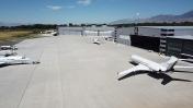
Airport Images

By: bob.cornett@dun...
By: bob.cornett@dun...
- 1 of 2
- next ›


Comments
KPVU Missing Chart Supplement Link
There is no link to the KPVU Chart Supplement, only the airport diagram.
Pages