Login
Register


FLO
Florence Regional Airport
Official FAA Data Effective 2026-01-22 0901Z
Chart Supplement

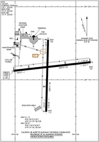
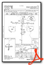
KFLO Airport Diagram
VFR Chart of KFLO
Sectional Charts at SkyVector.com
IFR Chart of KFLO
Enroute Charts at SkyVector.com
Location Information for KFLO
Coordinates: N34°11.12' / W79°43.43'Located 03 miles E of Florence, South Carolina on 1436 acres of land. View all Airports in South Carolina.
Surveyed Elevation is 146 feet MSL.
Operations Data
|
|
Airport Communications
| ATIS: | 123.625 |
|---|---|
| ASOS: | Tel. 843-665-1306 |
| FLORENCE TOWER: | 125.1 353.85 |
| FLORENCE GROUND: | 121.9 353.85 |
| FLORENCE APPROACH: | 118.6 ;256-074 135.25 ;075-255 316.15 ;075-255 341.7 ;256-074 |
| FLORENCE DEPARTURE: | 118.6 ;256-074 135.25 ;075-255 316.15 ;075-255 341.7 ;256-074 |
| CLEARANCE DELIVERY: | 121.9 353.85 |
| CTAF: | 125.100 |
| UNICOM: | 122.950 |
| AWOS-3PT at UDG (17.8 NW): | 119.925 843-393-8220 |
| AWOS-3PT at MAO (19.4 E): | 119.875 843-423-4231 |
| AWOS-3 at HVS (23.6 NW): | 118.225 843-339-9625 |
- APCH/DEP SVC PRVDD BY JACKSONVILLE ARTCC ON FREQS 133.45/306.3 (FLORENCE RCAG) WHEN FLORENCE APCH CTL CLSD.
Nearby Navigation Aids
|
| ||||||||||||||||||||||||||||||||||||||||||||||||||||||||||||


Runway 09/27
| Dimensions: | 6502 x 150 feet / 1982 x 46 meters | |
|---|---|---|
| Surface: | Asphalt / Grooved in Good Condition | |
| Weight Limits: | S-97, D-156, ST-261
PCR VALUE: 1130/F/A/X/T
| |
| Edge Lighting: | High Intensity | |
| Runway 09 | Runway 27 | |
| Coordinates: | N34°11.12' / W79°44.04' | N34°11.24' / W79°42.75' |
| Elevation: | 146.5 | 121.5 |
| Traffic Pattern: | Left | Left |
| Runway Heading: | 84° True | 264° True |
| Markings: | Precision Instrument in good condition. | Non-Precision Instrument in good condition. |
| Glide Slope Indicator | P4L (3.00° Glide Path Angle) | P4L (3.00° Glide Path Angle) |
| Approach Lights: | MALSR 1,400 Foot Medium-intensity Approach Lighting System with runway alignment indicator lights. | |
| REIL: | Yes | |
Runway 01/19
| Dimensions: | 6000 x 150 feet / 1829 x 46 meters | |
|---|---|---|
| Surface: | Asphalt in Fair Condition | |
| Weight Limits: | S-87, D-139, ST-238
PCR VALUE: 190/F/C/X/T
| |
| Edge Lighting: | Medium Intensity | |
| Runway 01 | Runway 19 | |
| Coordinates: | N34°10.56' / W79°43.49' | N34°11.55' / W79°43.46' |
| Elevation: | 112.2 | 143.4 |
| Traffic Pattern: | Left | Left |
| Runway Heading: | 1° True | 181° True |
| Markings: | Non-Precision Instrument in fair condition. | Non-Precision Instrument in good condition. |
| Glide Slope Indicator | P4L (3.00° Glide Path Angle) | P4L (3.00° Glide Path Angle) |
| REIL: | Yes | Yes |
| Obstacles: | 42 ft Tree 1250 ft from runway | 90 ft Trees 2000 ft from runway |
Services Available
| Fuel: | 100LL (blue), Jet-A |
|---|---|
| Transient Storage: | Hangars,Tiedowns |
| Airframe Repair: | MAJOR |
| Engine Repair: | MAJOR |
| Bottled Oxygen: | HIGH |
| Bulk Oxygen: | HIGH |
| Other Services: | CARGO HANDLING SERVICES,PILOT INSTRUCTION,AIRCRAFT RENTAL |
Ownership Information
| Ownership: | Publicly owned | |
|---|---|---|
| Owner: | PEE DEE REGIONAL ARPT AUTHORITY | |
| 2100 TERMINAL DRIVE | ||
| FLORENCE, SC 29506 | ||
| 843-669-5001 | ||
| Manager: | BRAD BEADLES | |
| 2100 TERMINAL DRIVE | ||
| FLORENCE, SC 29506 | ||
| 843-669-5001 | ||
Other Remarks
- 24 HR PPR FOR UNSKED ACR OPNS WITH MORE THAN 30 PSGR SEATS; CTC AMGR AT 843-669-5001.
- FOR CD IF UNA TO CTC ON FSS FREQ, CTC FLORENCE APCH AT 843-665-0632, WHEN APCH CLSD CTC JACKSONVILLE ARTCC AT 904-845-1592.
- WHEN ATCT CLSD ACTVT MALSR RWY 09; REIL RWY 01, 19 & 27; PAPI RWY 01 & 19; HIRL RWY 09/27; AND TWY LGTS - CTAF.
Weather Minimums

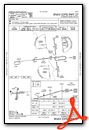
Instrument Approach Procedure (IAP) Charts


Nearby Airports with Instrument Procedures
| ID | Name | Heading / Distance | ||
|---|---|---|---|---|
 |
KUDG | Darlington County Airport | 332° | 17.7 |
|
KMAO | Marion County Airport | 090° | 19.4 |
|
51J | Lake City Municipal Cj Evans Field Airport | 186° | 20.0 |
|
KHVS | Hartsville Regional Airport | 303° | 23.6 |
|
KDLC | Dillon County Airport | 048° | 23.7 |
|
KBBP | Marlboro County Jetport/H E Avent Field Airport | 358° | 26.1 |
|
KCKI | Williamsburg Regional Airport | 193° | 28.8 |
|
KSMS | Sumter Airport | 250° | 33.7 |
|
KCQW | Cheraw Municipal/Lynch Bellinger Field Airport | 339° | 33.6 |
|
KHYW | Conway-Horry County Airport | 125° | 36.8 |
|
KSSC | Shaw AFB Airport | 251° | 39.3 |
|
KMEB | Laurinburg/Maxton Airport | 025° | 40.5 |
Airport Images

By: younghousehold


