Login
Register


GNT
Grants-Milan Municipal Airport
Official FAA Data Effective 2026-02-19 0901Z
Chart Supplement

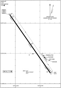
KGNT Airport Diagram
VFR Chart of KGNT
Sectional Charts at SkyVector.com
IFR Chart of KGNT
Enroute Charts at SkyVector.com
Location Information for KGNT
Coordinates: N35°10.04' / W107°54.12'Located 03 miles NW of Grants, New Mexico on 365 acres of land. View all Airports in New Mexico.
Surveyed Elevation is 6536 feet MSL.
Operations Data
|
|
Airport Communications
| AWOS-3PT: | 118.3 Tel. 505-287-9890 |
|---|---|
| UNICOM: | 122.800 |
| CTAF: | 122.800 |
| ASOS at GUP (48.2 NW): | 118.375 505-726-8232 |
| AWOS-3PT at XNI (51.5 W): | 119.275 505-356-2876 |
| ATIS at AEG (54.4 E): | 119.025 |
- APCH/DEP SVC PRVDD BY ALBUQUERQUE ARTCC (ZAB) ON FREQS 124.325/288.25 (WEST MESA RCAG).
Nearby Navigation Aids
|
| ||||||||||||||||||||||||||||||||||||||||||


Runway 13/31
| Dimensions: | 7172 x 75 feet / 2186 x 23 meters | |
|---|---|---|
| Surface: | Asphalt in Good Condition | |
| Weight Limits: | 4 /F/D/X/T, S-12 | |
| Edge Lighting: | Medium Intensity | |
| Runway 13 | Runway 31 | |
| Coordinates: | N35°10.64' / W107°54.61' | N35°9.67' / W107°53.79' |
| Elevation: | 6536.9 | 6518.1 |
| Traffic Pattern: | Left | Left |
| Runway Heading: | 145° True | 325° True |
| Markings: | Non-Precision Instrument in good condition. | Non-Precision Instrument in good condition. |
| Glide Slope Indicator | P2L (3.00° Glide Path Angle) | P2L (3.00° Glide Path Angle) |
Services Available
| Fuel: | 100LL (blue), Jet A-1+ |
|---|---|
| Transient Storage: | Hangars,Tiedowns AVBLTY - AMGR. |
| Airframe Repair: | NOT AVAILABLE |
| Engine Repair: | NOT AVAILABLE |
| Bottled Oxygen: | NOT AVAILABLE |
| Bulk Oxygen: | NOT AVAILABLE |
| Other Services: | AIR FREIGHT SERVICES,AIR AMBULANCE SERVICES |
Ownership Information
| Ownership: | Publicly owned | |
|---|---|---|
| Owner: | CITY OF GRANTS | |
| PO BOX 879 | ||
| GRANTS, NM 87020 | ||
| 505-287-7927 | ||
| Manager: | LYNN CANNON | |
| BOX 879 | ||
| GRANTS, NM 87020 | ||
| 505-287-4700 | ||
Other Remarks
- FOR CD CTC ALBUQUERQUE ARTCC AT 505-856-4861.
- SELF SVC FUEL WITH CREDIT CARD. JET A TRUCK AVBL. AFT HR CALL OUT FEE - AMGR.
- WILDLIFE ON OR INVOF ARPT.
- ACTVT MIRL RWY 13/31 - CTAF.
Weather Minimums
Instrument Approach Procedure (IAP) Charts

Nearby Airports with Instrument Procedures
| ID | Name | Heading / Distance | ||
|---|---|---|---|---|
 |
KGUP | Gallup Municipal Airport | 295° | 48.2 |
|
KAEG | Double Eagle II Airport | 091° | 54.5 |
|
KBRG | Belen Regional Airport | 120° | 61.2 |
|
KABQ | Albuquerque International Sunport Airport | 096° | 64.2 |
|
KRQE | Window Rock Airport | 297° | 64.1 |
|
KSJN | St Johns Industrial Air Park Airport | 242° | 82.6 |
|
KONM | Socorro Municipal Airport | 143° | 84.6 |
|
KLAM | Los Alamos Airport | 061° | 90.7 |
|
KSAF | Santa Fe Regional Airport | 072° | 92.9 |
|
KJTC | Springerville Municipal Airport | 228° | 93.4 |
|
0E0 | Moriarty Municipal Airport | 096° | 94.4 |
|
KFMN | Four Corners Regional Airport | 350° | 95.6 |
Airport Images
 Airport")
By: pataylo

By: Dave


