Login
Register


HAF
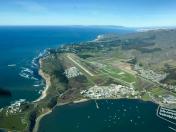
Half Moon Bay Airport
Official FAA Data Effective 2026-01-22 0901Z
Chart Supplement

VFR Chart of KHAF
Sectional Charts at SkyVector.com
IFR Chart of KHAF
Enroute Charts at SkyVector.com
Location Information for KHAF
Coordinates: N37°30.81' / W122°30.07'Located 05 miles NW of Half Moon Bay, California on 325 acres of land. View all Airports in California.
Surveyed Elevation is 66 feet MSL.
Operations Data
|
|
Airport Communications
| AWOS-3: | 127.275 Tel. 650-728-5649 |
|---|---|
| NORCAL APPROACH: | 135.1 307.2 |
| NORCAL DEPARTURE: | 135.1 307.2 |
| UNICOM: | 122.800 |
| CTAF: | 122.800 |
| D-ATIS at SFO (8.7 NE): | 118.85 |
| ASOS at SFO (9.1 NE): | 650-250-5841 |
| ATIS at SQL (12.0 E): | 125.9 |
Nearby Navigation Aids
|
| ||||||||||||||||||||||||||||||||||||

Runway 12/30
| Dimensions: | 5000 x 150 feet / 1524 x 46 meters | |
|---|---|---|
| Surface: | Asphalt-Concrete in Fair Condition | |
| Weight Limits: | S-30, D-200, ST-360 | |
| Edge Lighting: | Medium Intensity | |
| Runway 12 | Runway 30 | |
| Coordinates: | N37°31.11' / W122°30.42' | N37°30.51' / W122°29.72' |
| Elevation: | 66.3 | 32.5 |
| Traffic Pattern: | Left | Right |
| Runway Heading: | 137° True | 317° True |
| Displaced Threshold: | 752 Feet | 762 Feet |
| Markings: | Non-Precision Instrument in good condition. | Non-Precision Instrument in good condition. |
| Glide Slope Indicator | P2L (3.00° Glide Path Angle) | P2L (3.00° Glide Path Angle) |
| REIL: | Yes | |
| Obstacles: | 70 ft Trees 1390 ft from runway, 270 ft right of center APCH RATIO TO DSPLCD THR 50:1. |
70 ft Trees 2478 ft from runway, 180 ft right of center APCH RATIO TO DSPLCD THR 50:1. |
Services Available
| Fuel: | 100LL (blue) |
|---|---|
| Transient Storage: | Tiedowns |
| Airframe Repair: | NONE |
| Engine Repair: | NONE |
| Bottled Oxygen: | NONE |
| Bulk Oxygen: | NONE |
Ownership Information
| Ownership: | Publicly owned | |
|---|---|---|
| Owner: | SAN MATEO COUNTY | |
| 555 COUNTY CENTER, 5TH FLOOR | ||
| REDWOOD CITY, CA 94063-1665 | ||
| 650-573-3700 | DIRECTOR OF PUBLIC WORKS: JAMES C. PORTER | |
| Manager: | GRETCHEN KELLY | MANAGER LOCATED AT SAN CARLOS AIRPORT. |
| 620 AIRPORT DRIVE | ||
| SAN CARLOS, CA 94070 | ||
| 650-573-3700 | MANAGERS OFFICE AIRPORT PHONE 650-573-3701. | |
Other Remarks
- THIS AIRPORT HAS BEEN SURVEYED BY THE NATIONAL GEODETIC SURVEY.
- FLD CONDS-RWY, TWY & APRON GOOD.
- AVOID FLYING DIRECTLY OVER THE PILLAR POINT AIR FORCE STATION.
- ARPT NOISE SENSITIVE AREAS NW THRU NE.
- TWYS, APRONS AND TIEDOWNS: 12,500 LBS MAXIMUM.
- FOR CD CTC NORCAL APCH AT 916-361-0519.
- UNEXPECTED TURBULENT CONDS MAY BE ENCTRD WHILE ON FNA TO RWY 12.
- 0LL FUEL AVBL 24 HRS SELF SERVICE.
- ACTVT MIRL RY 12/30, REIL RY 30, PAPI RYS 12 AND 30 - 122.8.
Weather Minimums

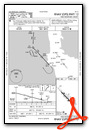
Instrument Approach Procedure (IAP) Charts

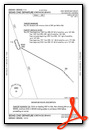
Departure Procedure Obstacles (DPO) Charts
Nearby Airports with Instrument Procedures
| ID | Name | Heading / Distance | ||
|---|---|---|---|---|
 |
KSFO | San Francisco International Airport | 043° | 8.7 |
|
KSQL | San Carlos Airport | 090° | 12.0 |
|
KOAK | Oakland San Francisco Bay Airport | 046° | 18.3 |
|
KPAO | Palo Alto Airport | 099° | 18.7 |
|
KHWD | Hayward Exec Airport | 064° | 20.1 |
|
KNUQ | Moffett Federal Airfield Airport | 104° | 22.4 |
|
KSJC | Norman Y Mineta San Jose International Airport | 108° | 28.8 |
|
CA35 | San Rafael Airport | 358° | 30.2 |
|
KLVK | Livermore Municipal Airport | 071° | 34.2 |
|
KRHV | Reid-Hillview of Santa Clara County Airport | 108° | 34.3 |
|
KCCR | Buchanan Field Airport | 036° | 35.5 |
|
KDVO | Gnoss Field Airport | 355° | 37.9 |