Login
Register


IDL
Indianola Municipal Airport
Official FAA Data Effective 2026-01-22 0901Z
Chart Supplement

VFR Chart of KIDL
Sectional Charts at SkyVector.com
IFR Chart of KIDL
Enroute Charts at SkyVector.com
Location Information for KIDL
Coordinates: N33°29.14' / W90°40.73'Located 02 miles NW of Indianola, Mississippi on 600 acres of land. View all Airports in Mississippi.
Surveyed Elevation is 126 feet MSL.
Operations Data
|
|
Airport Communications
| CTAF: | 122.800 |
|---|---|
| UNICOM: | 122.800 |
| ASOS at GLH (15.1 W): | 125.525 662-332-0863 |
| AWOS-3PT at RNV (17.0 N): | 124.175 662-843-3021 |
| ASOS at GWO (29.7 E): | 119.975 662-453-3304 |
- APCH/DEP SVC PRVDD BY MEMPHIS ARTCC ON FREQS 135.875/269.35 (GREENVILLE RCAG & PINE BLUFF RCAG).
Nearby Navigation Aids
|
| ||||||||||||||||||||||||||||||||||||||||||||||||||||||||||||


Runway 18/36
| Dimensions: | 7004 x 150 feet / 2135 x 46 meters | |
|---|---|---|
| Surface: | Concrete in Good Condition | |
| Weight Limits: | S-20 | |
| Edge Lighting: | Medium Intensity | |
| Runway 18 | Runway 36 | |
| Coordinates: | N33°29.72' / W90°40.73' | N33°28.57' / W90°40.73' |
| Elevation: | 126.0 | 120.3 |
| Traffic Pattern: | Left | Left |
| Runway Heading: | 180° True | 360° True |
| Markings: | Non-Precision Instrument in fair condition. | Non-Precision Instrument in fair condition. |
| Obstacles: | 35 ft Trees 1000 ft from runway | |
Services Available
| Fuel: | 100LL (blue) |
|---|---|
| Transient Storage: | Tiedowns PILOTS MUST PRVD THEIR OWN TIEDOWN ROPES. |
| Airframe Repair: | MAJOR AVBL ON REQ: 662-719-2682. |
| Engine Repair: | MAJOR AVBL ON REQ: 662-719-2682. |
| Bottled Oxygen: | NONE |
| Bulk Oxygen: | NONE |
| Other Services: | CROP DUSTING SERVICES |
Ownership Information
| Ownership: | Publicly owned | |
|---|---|---|
| Owner: | CITY OF INDIANOLA | |
| PO BOX 269 | ||
| INDIANOLA, MS 38751 | ||
| 662-887-3101 | ||
| Manager: | BAYLOR BRYANT | |
| BOX 662 | ||
| INDIANOLA, MS 38751 | ||
| 662-588-0580 | ||
Other Remarks
- TWY LGTS ON E-W TWY TO APN ONLY.
- FOR CD CTC MEMPHIS ARTCC AT 901-368-8453/8449.
- ACTVT MIRL RWY 18/36 - CTAF.
Weather Minimums
Instrument Approach Procedure (IAP) Charts
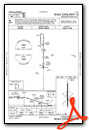
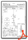
Nearby Airports with Instrument Procedures
| ID | Name | Heading / Distance | ||
|---|---|---|---|---|
 |
KGLH | Greenville Mid-Delta Airport | 269° | 15.3 |
|
KRNV | Cleveland Municipal Airport | 346° | 17.0 |
|
M37 | Ruleville-Drew Airport | 023° | 19.0 |
|
KGWO | Greenwood-Leflore Airport | 088° | 29.7 |
|
M32 | Lake Village Municipal Airport | 255° | 33.0 |
|
7M1 | Mc Gehee Municipal Airport | 283° | 35.3 |
|
87I | Yazoo County Airport | 163° | 37.7 |
|
19M | C A Moore Airport | 123° | 39.3 |
|
5A6 | Winona-Montgomery County Airport | 091° | 47.6 |
|
KGNF | Grenada Municipal Airport | 064° | 48.8 |
|
KMMS | Selfs Airport | 023° | 48.7 |
|
0M0 | Billy Free Municipal Airport | 299° | 49.0 |
Airport Images
Do you have a recent image of this airport? Upload it here!


