Login
Register
LEW
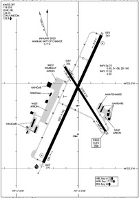
Auburn/Lewiston Municipal Airport
Official FAA Data Effective 2025-12-25 0901Z
VFR Chart of KLEW
Sectional Charts at SkyVector.com
IFR Chart of KLEW
Enroute Charts at SkyVector.com
Location Information for KLEW
Coordinates: N44°2.91' / W70°17.01'Located 04 miles SW of Auburn/Lewiston, Maine on 565 acres of land. View all Airports in Maine.
Surveyed Elevation is 287 feet MSL.
Operations Data
|
|
Airport Communications
| AWOS-3PT: | 118.025 Tel. 207-783-2806 |
|---|---|
| PORTLAND APPROACH: | 125.5 353.9 |
| PORTLAND DEPARTURE: | 125.5 353.9 |
| CLEARANCE DELIVERY: | 124.05 ;CTC APCH CTL |
| PRE TAXI CLNC: | 124.05 ;CTC APCH CTL |
| CTAF: | 122.800 |
| UNICOM: | 122.800 |
| AWOS-3PT at BXM (18.0 SE): | 134.875 207-409-1747 |
| ATIS at PWM (24.2 S): | 119.05 |
| ASOS at PWM (24.4 S): | 119.05 207-419-5584 |
- APCH/DEP SVC PRVDD BY BOSTON ARTCC ON FREQS 128.2 (WATERBORO RCAG) AND 290.50 (BANGOR RCAG) WHEN PORTLAND ATCT CLSD.
Nearby Navigation Aids
|
| ||||||||||||||||||||||||||||||||||||||||||||||||||||||||||||
Runway 04/22
| Dimensions: | 5001 x 100 feet / 1524 x 30 meters | |
|---|---|---|
| Surface: | Asphalt / Grooved in Excellent Condition | |
| Weight Limits: | S-30, D-108, ST-180 | |
| Edge Lighting: | High Intensity | |
| Runway 04 | Runway 22 | |
| Coordinates: | N44°2.53' / W70°17.28' | N44°3.28' / W70°16.81' |
| Elevation: | 270.4 | 263.1 |
| Traffic Pattern: | Left | Left |
| Runway Heading: | 24° True | 204° True |
| Markings: | Precision Instrument in good condition. | Non-Precision Instrument in good condition. |
| Glide Slope Indicator | P4L (3.00° Glide Path Angle) | P4L (3.50° Glide Path Angle) |
| Approach Lights: | MALSR 1,400 Foot Medium-intensity Approach Lighting System with runway alignment indicator lights. | |
| REIL: | Yes | |
| Obstacles: | 100 ft Trees 4450 ft from runway, 450 ft right of center | 62 ft Trees 849 ft from runway, 340 ft right of center 13 FT POLE 100 FT FM RWY END, 375 FT R, +5 FT ROADWAY 0-200 FT FM RWY END 0-350 FT R. |
Runway 17/35
| Dimensions: | 2750 x 75 feet / 838 x 23 meters | |
|---|---|---|
| Surface: | Asphalt in Excellent Condition | |
| Weight Limits: | S-30 | |
| Edge Lighting: | Medium Intensity | |
| Runway 17 | Runway 35 | |
| Coordinates: | N44°3.10' / W70°17.11' | N44°2.71' / W70°16.78' |
| Elevation: | 255.5 | 287.5 |
| Traffic Pattern: | Left | Left |
| Runway Heading: | 148° True | 328° True |
| Markings: | Basic in good condition. | Basic in good condition. |
| Obstacles: | 73 ft Tree 1508 ft from runway, 240 ft left of center | 58 ft Tree 1077 ft from runway, 199 ft right of center |
Services Available
| Fuel: | 100LL (blue), Jet A-1+ |
|---|---|
| Transient Storage: | Hangars,Tiedowns CALL AHD FOR AVBLTY. |
| Airframe Repair: | MAJOR |
| Engine Repair: | MAJOR |
| Bottled Oxygen: | LOW |
| Bulk Oxygen: | NONE |
Ownership Information
| Ownership: | Publicly owned | |
|---|---|---|
| Owner: | CITIES OF AUBURN & LEWISTON | |
| 80 AIRPORT DR | ||
| AUBURN, ME 04210 | ||
| 207-786-0631 | ||
| Manager: | JONATHAN LABONTE | AUBURN CITY TRANSPORTATION DIR. |
| 80 AIRPORT DR | ||
| AUBURN, ME 04210 | ||
| 207-786-0631 | ||
Other Remarks
- THIS AIRPORT HAS BEEN SURVEYED BY THE NATIONAL GEODETIC SURVEY.
- BIRDS ON & INVOF ARPT.
- RWY 04 DSGND CALM WIND RWY.
- OCNL BLASTING IN PROG MON-SAT APRXLY 4800-5000 FT SW OF RWY 04 THR 1100-1500 DURG VFR CONDS ONLY.
- INTENSIVE HOP DLY FM 0500-2000. HEL TFC PAT 500 AGL, RIGHT TFC.
- ACFT DE-ICING AVBL.
- FOR CD WHEN APCH CLSD CTC BOSTON ARTCC AT 603-879-6859.
- 0LL FOR FUEL OR SVCS AFT HRS CALL 207-784-6318.
- ACTVT MALSR RWY 04; REIL RWY 22; HIRL RWY 04/22 & MIRL RWY 17/35 - CTAF.
- EXISTED PRIOR TO 1959.
Weather Minimums
Instrument Approach Procedure (IAP) Charts
Nearby Airports with Instrument Procedures
| ID | Name | Heading / Distance | ||
|---|---|---|---|---|
 |
81B | Oxford County Regional Airport | 307° | 10.8 |
 |
KBXM | Brunswick Exec Airport | 121° | 17.6 |
 |
KPWM | Portland International Jetport Airport | 182° | 24.2 |
 |
KIWI | Wiscasset Airport | 101° | 25.3 |
 |
KAUG | Augusta State Airport | 051° | 26.6 |
 |
KIZG | White Mountain Regional Airport | 263° | 29.0 |
 |
0B1 | Bethel Regional Airport | 315° | 32.0 |
 |
B19 | Biddeford Municipal Airport | 193° | 36.0 |
 |
KWVL | Waterville Regional Airport | 041° | 39.1 |
 |
KSFM | Sanford Seacoast Regional Airport | 205° | 43.4 |
 |
KOWK | Central Maine/Norridgewock Airport | 024° | 43.9 |
 |
KBML | Berlin Regional Airport | 309° | 49.8 |


