Login
Register


PAH
Barkley Regional Airport
Official FAA Data Effective 2026-02-19 0901Z
Chart Supplement

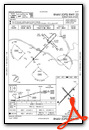
KPAH Airport Diagram

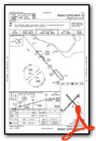
VFR Chart of KPAH
Sectional Charts at SkyVector.com
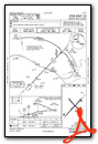
IFR Chart of KPAH
Enroute Charts at SkyVector.com
Location Information for KPAH
Coordinates: N37°3.62' / W88°46.38'Located 09 miles W of Paducah, Kentucky on 1018 acres of land. View all Airports in Kentucky.
Surveyed Elevation is 410 feet MSL.
Operations Data
|
|
Airport Communications
| ASOS: | 118.375 Tel. 270-366-0642 |
|---|---|
| PADUCAH TOWER: | 119.6 306.9 |
| PADUCAH GROUND: | 121.7 306.9 |
| CTAF: | 119.600 |
| UNICOM: | 122.950 |
| AWOS-3 at M30 (7.4 N): | 124.175 618-524-7483 |
| AWOS-3 at M25 (19.7 SE): | 120.625 270-247-2094 |
| AWOS-3 at CIR (21.4 W): | 118.025 618-734-9173 |
- ATCT LEASED TO CITY OPERATED BY ARPT COMMISSION.
- APCH/DEP SVC PRVDD BY MEMPHIS ARTCC ON FREQS 133.65/292.15 (PADUCAH RCAG).
Nearby Navigation Aids
|
| ||||||||||||||||||||||||||||||||||||||||||||||||||||||||||||


Runway 05/23
ACFT OPS NOT VSB FM OPPOSITE RWY ENDS DUE TO GRADE. | ||
| Dimensions: | 6500 x 150 feet / 1981 x 46 meters | |
|---|---|---|
| Surface: | Asphalt / Grooved in Good Condition | |
| Weight Limits: | S-76, D-99, ST-170
PCR VALUE: 860/F/B/X/T
| |
| Edge Lighting: | High Intensity | |
| Runway 05 | Runway 23 | |
| Coordinates: | N37°3.21' / W88°46.89' | N37°3.98' / W88°45.97' |
| Elevation: | 410.3 | 381.2 |
| Traffic Pattern: | Left | Left |
| Runway Heading: | 44° True | 224° True |
| Declared Distances: | TORA:6500 TODA:6500 ASDA:6500 LDA:6500 | TORA:6500 TODA:6500 ASDA:6500 LDA:6500 |
| Markings: | Precision Instrument in good condition. | Precision Instrument in good condition. |
| Glide Slope Indicator | P4L (3.00° Glide Path Angle) | |
| Approach Lights: | MALSR 1,400 Foot Medium-intensity Approach Lighting System with runway alignment indicator lights. | |
| REIL: | Yes | |
| Obstacles: | 37 ft Pole 1600 ft from runway, 312 ft right of center | 28 ft Trees 1000 ft from runway, 500 ft left of center |
Runway 14/32
| Dimensions: | 5499 x 150 feet / 1676 x 46 meters | |
|---|---|---|
| Surface: | Asphalt / Grooved in Good Condition | |
| Weight Limits: | S-75, D-100, ST-170
PCR VALUE: 550/F/D/X/T
| |
| Edge Lighting: | Medium Intensity | |
| Runway 14 | Runway 32 | |
| Coordinates: | N37°3.99' / W88°46.69' | N37°3.30' / W88°45.95' |
| Elevation: | 392.3 | 409.4 |
| Traffic Pattern: | Left | Left |
| Runway Heading: | 139° True | 319° True |
| Displaced Threshold: | 100 Feet | |
| Declared Distances: | TORA:5499 TODA:5499 ASDA:5499 LDA:5399 | TORA:5499 TODA:5499 ASDA:5324 LDA:5324 |
| Markings: | Non-Precision Instrument in good condition. | Non-Precision Instrument in good condition. |
| Glide Slope Indicator | P4L (3.00° Glide Path Angle) | |
| REIL: | Yes | |
| Obstacles: | 26 ft Tree 900 ft from runway, 200 ft left of center | 71 ft Trees 1175 ft from runway, 390 ft right of center |
Services Available
| Fuel: | 100LL (blue), Jet-A |
|---|---|
| Transient Storage: | Hangars,Tiedowns |
| Airframe Repair: | MAJOR |
| Engine Repair: | MAJOR |
| Bottled Oxygen: | HIGH |
| Bulk Oxygen: | NOT AVAILABLE |
| Other Services: | AVIONICS |
Ownership Information
| Ownership: | Publicly owned | |
|---|---|---|
| Owner: | BARKLEY REGIONAL AIRPORT AUTHORITY | |
| 100 TERMINAL DRIVE | ||
| WEST PADUCAH, KY 42086-1131 | ||
| 270-744-0521 | ||
| Manager: | DENNIS ROULEAU | |
| 100 TERMINAL DRIVE | ||
| WEST PADUCAH, KY 42086-1131 | ||
| 270-744-0521 | ||
Other Remarks
- NWS ON ARPT - 270-744-6440.
- SFC COND NOT MNTD 0600-1800. WET SFC COND NOT RPRTD.
- FOR CD CTC MEMPHIS ARTCC AT 901-368-8453/8449.
- ARPT MNTNS INDEX A; INDEX B AVBL UPON REQ .
- WHEN ATCT CLSD ACTVT MALSR RWY 05; REIL RWY 23 & 32; PAPI RWY 23 &32; HIRL RWY 05/23; MIRL RWY 14/32; TWY LGTS; LGTD WIND CONE - CTAF.
Weather Minimums

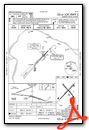
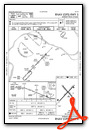
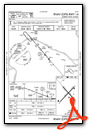
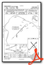
Instrument Approach Procedure (IAP) Charts
Nearby Airports with Instrument Procedures
| ID | Name | Heading / Distance | ||
|---|---|---|---|---|
 |
M25 | Mayfield Graves County Airport | 152° | 19.6 |
|
KCIR | Cairo Regional Airport | 270° | 21.4 |
|
M34 | Kentucky Dam State Park Airport | 097° | 22.9 |
|
KCEY | Kyle-Oakley Field Airport | 140° | 30.6 |
|
KCHQ | Mississippi County Airport | 245° | 31.1 |
|
1M7 | Fulton Airport | 192° | 32.8 |
|
KGDA | Marion-Crittenden County James C Johnson Regional Airport | 062° | 35.8 |
|
KSIK | Sikeston Memorial Municipal Airport | 255° | 39.1 |
|
KCGI | Cape Girardeau Regional Airport | 284° | 39.5 |
|
KUCY | Everett-Stewart Regional Airport | 194° | 42.1 |
|
KMWA | Veterans Airport of Southern Illinois Airport | 344° | 43.2 |
|
2M0 | Princeton-Caldwell County Airport | 085° | 44.1 |
Airport Images
Do you have a recent image of this airport? Upload it here!


