Login
Register


PYP
Centre Piedmont/Cherokee County Regional Airport
Official FAA Data Effective 2026-01-22 0901Z
Chart Supplement

VFR Chart of KPYP
Sectional Charts at SkyVector.com
IFR Chart of KPYP
Enroute Charts at SkyVector.com
Location Information for KPYP
Coordinates: N34°5.40' / W85°36.60'Located 05 miles S of Centre, Alabama on 308 acres of land. View all Airports in Alabama.
Estimated Elevation is 594 feet MSL.
Operations Data
|
|
Airport Communications
| CTAF: | 122.900 |
|---|---|
| AWOS-3PT at 4A9 (23.7 N): | 119.025 256-845-5397 |
| AWOS-3PT at GAD (24.9 W): | 127.825 256-442-7094 |
| ASOS at RMG (27.4 NE): | 119.925 706-204-9617 |
- APCH/DEP SVC PRVDD BY ATLANTA ARTCC ON FREQS 124.5/270.325 (GADSDEN RCAG).
Nearby Navigation Aids
|
| ||||||||||||||||||||||||||||||||||||||||||||||||||||||||||||


Runway 07/25
| Dimensions: | 5500 x 100 feet / 1676 x 30 meters | |
|---|---|---|
| Surface: | Asphalt / Aggregate Friction Seal Coated in Good Condition | |
| Edge Lighting: | Medium Intensity | |
| Runway 07 | Runway 25 | |
| Coordinates: | N34°5.19' / W85°37.09' | N34°5.60' / W85°36.12' |
| Elevation: | 584.4 | 594.6 |
| Runway Heading: | 63° True | 243° True |
| Markings: | Non-Precision Instrument in fair condition. | Non-Precision Instrument in fair condition. |
| Obstacles: | 75 ft Trees 2777 ft from runway, 43 ft left of center | |
Services Available
| Fuel: | 100LL (blue) |
|---|---|
| Transient Storage: | Tiedowns |
| Airframe Repair: | NOT AVAILABLE |
| Engine Repair: | NOT AVAILABLE |
| Bottled Oxygen: | NOT AVAILABLE |
| Bulk Oxygen: | NOT AVAILABLE |
Ownership Information
| Ownership: | Publicly owned | |
|---|---|---|
| Owner: | CPCCR AIRPORT AUTHORITY | |
| P.O. BOX 466, 8850 ALABAMA HWY 9 S | ||
| CENTRE, AL 35960 | ||
| 256-927-8009 | ||
| Manager: | DONNIE FREE | |
| P.O. 466, 8850 ALABAMA HWY 9 S | ||
| CENTRE, AL 35960 | ||
| 256-927-8009 | ||
Other Remarks
- FOR CD CTC ATLANTA ARTCC AT 770-210-7692.
- ACTVT MIRL RWY 07/25 - CTAF.
Weather Minimums

Instrument Approach Procedure (IAP) Charts
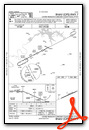
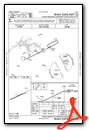
Nearby Airports with Instrument Procedures
| ID | Name | Heading / Distance | ||
|---|---|---|---|---|
 |
4A4 | Polk County/Cornelius Moore Field Airport | 100° | 23.6 |
|
4A9 | Isbell Field Airport | 346° | 23.6 |
|
KGAD | Northeast Alabama Regional Airport | 253° | 25.0 |
|
KRMG | Richard B Russell Regional - J H Towers Field Airport | 054° | 27.4 |
|
KANB | Anniston Regional Airport | 202° | 32.5 |
|
KBFZ | Albertville Regional/Thomas J Brumlik Field Airport | 284° | 33.2 |
|
KPUJ | Paulding Northwest Atlanta Airport | 107° | 35.1 |
|
KCTJ | West Georgia Regional/O V Gray Field Airport | 140° | 35.7 |
|
8A1 | Guntersville Municipal/Joe Starnes Field Airport | 300° | 37.5 |
|
KVPC | Cartersville Airport | 086° | 38.0 |
|
KASN | Talladega Municipal Airport | 215° | 38.2 |
|
20A | Robbins Field Airport | 259° | 39.1 |
Airport Images
Do you have a recent image of this airport? Upload it here!


