Login
Register


CTJ
West Georgia Regional/O V Gray Field Airport
Official FAA Data Effective 2025-12-25 0901Z
Chart Supplement

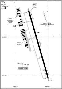
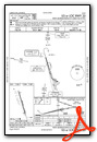
KCTJ Airport Diagram
VFR Chart of KCTJ
Sectional Charts at SkyVector.com
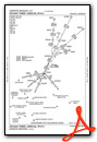
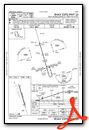
IFR Chart of KCTJ
Enroute Charts at SkyVector.com
Location Information for KCTJ
Coordinates: N33°37.90' / W85°9.14'Located 05 miles NW of Carrollton, Georgia on 481 acres of land. View all Airports in Georgia.
Surveyed Elevation is 1164 feet MSL.
Operations Data
|
|
Airport Communications
| AWOS-3: | 118.175 Tel. 770-214-9667 |
|---|---|
| ATLANTA APPROACH: | 121.0 268.7 |
| ATLANTA DEPARTURE: | 121.0 268.7 |
| CLEARANCE DELIVERY: | 121.6 |
| CTAF: | 122.975 |
| UNICOM: | 122.975 |
| AWOS-3 at PUJ (20.0 NE): | 126.225 770-445-3870 |
| AWOS-3PT at CCO (27.1 SE): | 118.975 770-254-1617 |
| ATIS at FTY (32.7 E): | 120.175 |
Nearby Navigation Aids
|
| ||||||||||||||||||||||||||||||||||||||||||||||||||||||||||||


Runway 17/35
| Dimensions: | 5503 x 100 feet / 1677 x 30 meters | |
|---|---|---|
| Surface: | Asphalt in Good Condition | |
| Weight Limits: | S-43, D-56, ST-83 | |
| Edge Lighting: | High Intensity | |
| Runway 17 | Runway 35 | |
| Coordinates: | N33°38.34' / W85°9.29' | N33°37.47' / W85°8.98' |
| Elevation: | 1164.6 | 1110.5 |
| Traffic Pattern: | Left | Left |
| Runway Heading: | 164° True | 344° True |
| Markings: | Non-Precision Instrument in good condition. | Precision Instrument in good condition. |
| Glide Slope Indicator | P4L (3.00° Glide Path Angle) | P4L (3.00° Glide Path Angle) |
| Obstacles: | 92 ft Trees 2341 ft from runway, 401 ft left of center | 34 ft Trees 948 ft from runway, 575 ft right of center |
Services Available
| Fuel: | 100LL (blue), Jet A+ |
|---|---|
| Transient Storage: | Hangars,Tiedowns |
| Airframe Repair: | MAJOR |
| Engine Repair: | MAJOR |
| Bottled Oxygen: | NONE |
| Bulk Oxygen: | NONE |
| Other Services: | AVIONICS,PILOT INSTRUCTION,AIRCRAFT RENTAL |
Ownership Information
| Ownership: | Publicly owned | |
|---|---|---|
| Owner: | WEST GA ARPT AUTH | |
| 635 REGIONAL AIRPORT ROAD | ||
| CARROLLTON, GA 30117 | ||
| 770-354-5927 | ||
| Manager: | MARK WEINSTEIN | |
| 635 REGIONAL AIRPORT ROAD | ||
| CARROLLTON, GA 30117 | ||
| 470-431-0366 | ||
Other Remarks
- DEER AND TURKEYS ON & NEAR RWYS AT ALL TIMES.
- FOR APCH/DEP SVC CTC ATLANTA APCH AT 678-364-6131. IF RLS TIME IS EXPD TO BE LESS THAN 5 MINS, CTC CD.
- HIRL RWY 17/35 PRESET MED INTST DUSK-2200, AFT 2200 ACTVT - CTAF. PAPI RWY 17 & 35 OPER CONSLY.
Weather Minimums
Standard Terminal Arrival (STAR) Charts
Instrument Approach Procedure (IAP) Charts

Nearby Airports with Instrument Procedures
| ID | Name | Heading / Distance | ||
|---|---|---|---|---|
 |
KPUJ | Paulding Northwest Atlanta Airport | 032° | 19.8 |
|
4A4 | Polk County/Cornelius Moore Field Airport | 000° | 23.2 |
|
KCCO | Newnan Coweta County Airport | 134° | 27.1 |
|
KFTY | Fulton County Exec/Charlie Brown Field Airport | 074° | 32.7 |
|
KVPC | Cartersville Airport | 027° | 33.1 |
|
KFFC | Atlanta Regional Falcon Field Airport | 119° | 33.4 |
|
KANB | Anniston Regional Airport | 265° | 35.5 |
|
KPYP | Centre Piedmont/Cherokee County Regional Airport | 320° | 35.7 |
|
KRYY | Cobb County International/Mccollum Field Airport | 050° | 35.9 |
|
KMGE | Dobbins Arb Airport | 061° | 36.1 |
|
KATL | Hartsfield/Jackson Atlanta International Airport | 089° | 36.3 |
|
KLGC | Lagrange/Callaway Airport | 173° | 37.5 |
Airport Images
Do you have a recent image of this airport? Upload it here!


