Login
Register


RCE
Clarence E Page Municipal Airport
Official FAA Data Effective 2026-01-22 0901Z
Chart Supplement

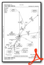
KRCE Airport Diagram

VFR Chart of KRCE
Sectional Charts at SkyVector.com
IFR Chart of KRCE
Enroute Charts at SkyVector.com
Location Information for KRCE
Coordinates: N35°29.28' / W97°49.41'Located 15 miles W of Oklahoma City, Oklahoma on 1000 acres of land. View all Airports in Oklahoma.
Surveyed Elevation is 1353 feet MSL.
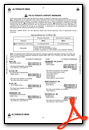
Operations Data
|
|
Airport Communications
| AWOS-3: | 125.05 Tel. 405-354-2617 |
|---|---|
| OKE CITY APPROACH: | 124.6 266.8 |
| OKE CITY DEPARTURE: | 124.6 266.8 |
| CTAF: | 123.000 |
| UNICOM: | 123.000 |
| AWOS-3 at HSD (8.8 NE): | 120.975 405-283-9848 |
| AWOS-3 at RQO (9.0 W): | 118.475 405-262-0087 |
| ASOS at PWA (9.1 E): | 405-798-2013 |
Nearby Navigation Aids
|
| ||||||||||||||||||||||||||||||||||||||||||||||||||||||||||||


Runway 17R/35L
| Dimensions: | 6014 x 100 feet / 1833 x 30 meters | |
|---|---|---|
| Surface: | Concrete in Good Condition | |
| Weight Limits: | S-40, D-60 | |
| Edge Lighting: | High Intensity | |
| Runway 17R | Runway 35L | |
| Coordinates: | N35°29.78' / W97°49.49' | N35°28.79' / W97°49.49' |
| Elevation: | 1350.5 | 1342.3 |
| Traffic Pattern: | Right | |
| Runway Heading: | 180° True | 360° True |
| Markings: | Non-Precision Instrument in fair condition. | Non-Precision Instrument in fair condition. |
| Glide Slope Indicator | P4L (3.00° Glide Path Angle) | P4L (3.00° Glide Path Angle) |
| Obstacles: | 10 ft Other 255 ft from runway, 231 ft right of center OIL WELL. |
26 ft Trees 850 ft from runway, 330 ft right of center |
Runway 17L/35R
| Dimensions: | 3502 x 75 feet / 1067 x 23 meters | |
|---|---|---|
| Surface: | Concrete in Good Condition | |
| Weight Limits: | S-17 | |
| Edge Lighting: | Medium Intensity | |
| Runway 17L | Runway 35R | |
| Coordinates: | N35°29.58' / W97°49.29' | N35°29.00' / W97°49.29' |
| Elevation: | 1343.0 | 1339.0 |
| Traffic Pattern: | Left | Right |
| Runway Heading: | 180° True | 360° True |
| Markings: | Basic in good condition. | Basic in good condition. |
Services Available
| Fuel: | 100LL (blue), Jet A+ |
|---|---|
| Transient Storage: | Tiedowns |
| Airframe Repair: | MAJOR |
| Engine Repair: | MAJOR |
| Bottled Oxygen: | HIGH |
| Bulk Oxygen: | NONE |
Ownership Information
| Ownership: | Publicly owned | |
|---|---|---|
| Owner: | CITY OF OKLAHOMA CITY | |
| 7100 TERMINAL DR., BOX 937 | ||
| OKLAHOMA CITY, OK 73159 | ||
| (405) 316-3200 | ||
| Manager: | KRISTY SLATER | |
| 5915 PHILLIP J. RHOADES RM 104 | ||
| BETHANY, OK 73008 | ||
| 405-316-4061 | ||
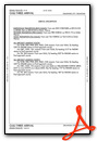
Other Remarks
- THIS AIRPORT HAS BEEN SURVEYED BY THE NATIONAL GEODETIC SURVEY.
- DEER ON & INVOF RY.
- AEROBATIC ACFT BLO 6400 FT 1 NM RADIUS OF ARPT.
- SFC CONDS RPTD MON-FRI 0800-1700.
- FOR CD CTC OKE CITY APCH AT 405-681-5683.
- DUSK-DAWN. ACTVT HIRL RY 17R/35L & MIRL 17L/35R - CTAF.
Weather Minimums

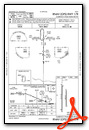
Standard Terminal Arrival (STAR) Charts
Instrument Approach Procedure (IAP) Charts
Nearby Airports with Instrument Procedures
| ID | Name | Heading / Distance | ||
|---|---|---|---|---|
 |
KHSD | Sundance Airport | 040° | 8.9 |
|
KRQO | El Reno Regional Airport | 264° | 9.0 |
|
KPWA | Wiley Post Airport | 072° | 9.1 |
|
KOKC | Okc Will Rogers International Airport | 117° | 12.3 |
|
KTIK | Tinker AFB Airport | 101° | 21.9 |
|
KOUN | University of Oklahoma Westheimer Airport | 130° | 22.5 |
|
KCHK | Chickasha Municipal Airport | 196° | 24.5 |
|
2O8 | Hinton Municipal Airport | 272° | 25.5 |
|
1K4 | David Jay Perry Airport | 138° | 26.4 |
|
KGOK | Guthrie/Edmond Regional Airport | 042° | 29.5 |
|
KJWG | Watonga Regional Airport | 307° | 36.9 |
|
KOJA | Weatherford Stafford Airport | 275° | 41.5 |
Airport Images
By: mendoza3
By: krruser


