Login
Register


RVL
Mifflin County Airport
Official FAA Data Effective 2025-12-25 0901Z
Chart Supplement

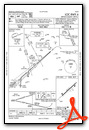
VFR Chart of KRVL
Sectional Charts at SkyVector.com
IFR Chart of KRVL
Enroute Charts at SkyVector.com
Location Information for KRVL
Coordinates: N40°40.64' / W77°37.61'Located 05 miles NW of Reedsville, Pennsylvania on 125 acres of land. View all Airports in Pennsylvania.
Surveyed Elevation is 818 feet MSL.
Operations Data
|
|
Airport Communications
| AWOS-3PT: | 123.85 Tel. 717-667-3993 |
|---|---|
| CTAF: | 122.700 |
| UNICOM: | 122.700 |
| ASOS at FLF (12.6 NW): | 814-237-5778 |
| D-ATIS at UNV (14.4 NW): | 127.65 |
| AWOS-3 at UNV (14.4 NW): | 127.65 814-865-8799 |
- APCH/DEP SVC PRVDD BY NEW YORK ARTCC ON FREQS 134.8/338.3 (PHILIPSBURG RCAG).
Nearby Navigation Aids
|
| ||||||||||||||||||||||||||||||||||||||||||||||||


Runway 06/24
| Dimensions: | 5001 x 75 feet / 1524 x 23 meters | |
|---|---|---|
| Surface: | Asphalt in Good Condition | |
| Weight Limits: | S-60 | |
| Edge Lighting: | Medium Intensity | |
| Runway 06 | Runway 24 | |
| Coordinates: | N40°40.37' / W77°38.02' | N40°40.91' / W77°37.20' |
| Elevation: | 815.5 | 809.8 |
| Traffic Pattern: | Left | Left |
| Runway Heading: | 49° True | 229° True |
| Markings: | Non-Precision Instrument in good condition. | Non-Precision Instrument in good condition. |
| Glide Slope Indicator | P2L (4.00° Glide Path Angle) | P4L (3.00° Glide Path Angle) |
| REIL: | Yes | Yes |
| Obstacles: | 125 ft Trees 2965 ft from runway, 166 ft left of center | 17 ft Trees 755 ft from runway, 285 ft left of center |
Services Available
| Fuel: | 100LL (blue), Jet-A |
|---|---|
| Transient Storage: | Tiedowns |
| Airframe Repair: | MAJOR |
| Engine Repair: | MAJOR |
| Bottled Oxygen: | NONE |
| Bulk Oxygen: | NONE |
| Other Services: | GLIDER SERVICE,GLIDER TOWING SERVICES |
Ownership Information
| Ownership: | Publicly owned | |
|---|---|---|
| Owner: | MIFFLIN COUNTY ARPT AUTH. | |
| PO BOX 461 | ||
| REEDSVILLE, PA 17084 | ||
| 717-667-6829 | ||
| Manager: | LARRY MCCARL | |
| 547 AIRPORT ROAD | ||
| REEDSVILLE, PA 17084 | ||
| 717-667-6829 | ||
Other Remarks
- THIS AIRPORT HAS BEEN SURVEYED BY THE NATIONAL GEODETIC SURVEY.
- HELICOPTERS LAND ON APRON.
- GLIDER ACTIVITY DURING SUMMER MONTHS.
- PHONE NUMBERS POSTED ON THE OFFICE DOOR FOR AFTER HOUR CALLS.
- FOR CD CTC NEW YORK ARTCC AT 631-468-1425.
- 0LL 100LL FUEL SS-24 HRS.
- JET-A FUEL BY APNTMT ONLY AFT HRS. CALL 717-994-0323 DURG ATNDD HRS TO MAKE APNTMT.
- ACTVT REIL RWY 06 & 24; PAPI RWY 06 & 24; MIRL RWY 06/24 - CTAF.
Weather Minimums
Instrument Approach Procedure (IAP) Charts
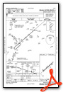
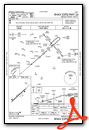
Nearby Airports with Instrument Procedures
| ID | Name | Heading / Distance | ||
|---|---|---|---|---|
 |
P34 | Mifflintown Airport | 114° | 11.1 |
|
KUNV | State College Regional Airport | 315° | 14.4 |
|
N96 | Bellefonte Airport | 325° | 15.2 |
|
KPSB | Mid-State Airport | 300° | 24.4 |
|
KLHV | William T Piper Memorial Airport | 018° | 29.0 |
|
KSEG | Penn Valley Airport | 075° | 35.8 |
|
N94 | Carlisle Airport | 144° | 35.9 |
|
KAOO | Altoona/Blair County Airport | 234° | 39.1 |
|
KFIG | Clearfield-Lawrence Airport | 302° | 42.2 |
|
N68 | Franklin County Regional Airport | 181° | 42.2 |
|
KCXY | Capital City Airport | 127° | 45.0 |
|
KIPT | Williamsport Regional Airport | 043° | 46.6 |


