Login
Register


IPT
Williamsport Regional Airport
Official FAA Data Effective 2026-01-22 0901Z
Chart Supplement

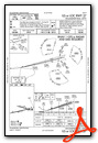
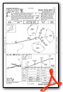
KIPT Airport Diagram

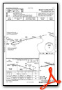
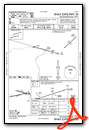
VFR Chart of KIPT
Sectional Charts at SkyVector.com
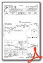
IFR Chart of KIPT
Enroute Charts at SkyVector.com
Location Information for KIPT
Coordinates: N41°14.50' / W76°55.31'Located 04 miles E of Williamsport, Pennsylvania on 535 acres of land. View all Airports in Pennsylvania.
Surveyed Elevation is 528 feet MSL.
Operations Data
|
|
Airport Communications
| ASOS: | 125.225 Tel. 570-360-5258 |
|---|---|
| WILLIAMSPORT TOWER: | 119.1 257.8 |
| WILLIAMSPORT GROUND: | 121.9 |
| EMERG: | 121.5 243.0 |
| CTAF: | 119.100 |
| UNICOM: | 122.950 |
| AWOS-3 at 79PN (21.8 SE): | 118.075 570-271-8192 |
| ASOS at SEG (25.4 S): | 123.975 570-374-4099 |
| AWOS-3 at N79 (29.5 SE): | 119.175 570-672-0389 |
- APCH/DEP SVC PRVDD BY NEW YORK ARTCC ON FREQ 124.9 (WILLIAMSPORT RCAG).
- WHEN ATCT CLSD NEW YORK ARTCC PROVIDES CLNC DEL ON FREQ 124.9.
- COMMUNICATIONS PRVDD BY WILLIAMSPORT RADIO ON FREQ 122.2 (WILLIAMSPORT RCO).
Nearby Navigation Aids
|
| ||||||||||||||||||||||||||||||||||||||||||||||||||||||


Runway 09/27
| Dimensions: | 6825 x 150 feet / 2080 x 46 meters | |
|---|---|---|
| Surface: | Asphalt / Grooved in Good Condition | |
| Weight Limits: | S-65, D-100, ST-190
PCR VALUE: 690/F/A/X/T
| |
| Edge Lighting: | High Intensity | |
| Runway 09 | Runway 27 | |
| Coordinates: | N41°14.31' / W76°56.14' | N41°14.56' / W76°54.69' |
| Elevation: | 513.8 | 525.2 |
| Traffic Pattern: | Left | Right |
| Runway Heading: | 77° True | 257° True |
| Displaced Threshold: | 255 Feet | |
| Declared Distances: | TORA:6825 TODA:6825 ASDA:6073 LDA:6073 | TORA:6825 TODA:6825 ASDA:6318 LDA:6063 |
| Markings: | Precision Instrument in fair condition. | Precision Instrument in fair condition. |
| Glide Slope Indicator | P4L (3.00° Glide Path Angle) RWY 09 PAPI BAFFLED UNUSBL BYD 2 DEGS R OF CRS. | |
| Approach Lights: | MALSR 1,400 Foot Medium-intensity Approach Lighting System with runway alignment indicator lights. | |
| REIL: | Yes | |
| Obstacles: | 62 ft Trees 657 ft from runway, 441 ft left of center 16:1 TO DSPLCD THLD. |
77 ft Trees 955 ft from runway, 552 ft left of center |
Runway 12/30
| Dimensions: | 4273 x 150 feet / 1302 x 46 meters | |
|---|---|---|
| Surface: | Asphalt in Good Condition | |
| Weight Limits: | S-200, D-200, ST-400
PCR VALUE: 2230/F/C/X/T
| |
| Edge Lighting: | Medium Intensity | |
| Runway 12 | Runway 30 | |
| Coordinates: | N41°14.70' / W76°55.59' | N41°14.51' / W76°54.69' |
| Elevation: | 523.0 | 525.6 |
| Traffic Pattern: | Left | Right |
| Runway Heading: | 106° True | 286° True |
| Declared Distances: | TORA:4273 TODA:4273 ASDA:4273 LDA:4273 | TORA:4273 TODA:4273 ASDA:4273 LDA:4273 |
| Markings: | Non-Precision Instrument in fair condition. | Non-Precision Instrument in fair condition. |
| Glide Slope Indicator | P2L (3.75° Glide Path Angle) | P2L (4.00° Glide Path Angle) RWY 30 PAPI BAFFLED UNUSBL BYD 7 DEGS L OF CRS. |
| Obstacles: | 97 ft Trees 2002 ft from runway, 511 ft left of center | 32 ft Trees 334 ft from runway, 263 ft left of center |
Services Available
| Fuel: | 100LL (blue), Jet-A |
|---|---|
| Transient Storage: | Hangars,Tiedowns |
| Airframe Repair: | MAJOR |
| Engine Repair: | MAJOR |
| Bottled Oxygen: | NONE |
| Bulk Oxygen: | HIGH |
| Other Services: | AVIONICS,CARGO HANDLING SERVICES,PILOT INSTRUCTION,AIRCRAFT RENTAL,AIRCRAFT SALES |
Ownership Information
| Ownership: | Publicly owned | |
|---|---|---|
| Owner: | WILLIAMSPORT MUNI ARPT AUTH | |
| 724 AIRPORT RD | ||
| MONTOURSVILLE, PA 17754 | ||
| 570-368-2444 | ||
| Manager: | ERIC MCKITISH | |
| 724 AIRPORT RD | ||
| MONTOURSVILLE, PA 17754 | ||
| 570-368-2444 | ||
Other Remarks
- DEER & BIRDS ON & INVOF ARPT SPCLY AER 27 & AER 30
- TWY 'J' CLSD TO ACFT WITH WING SPAN OVER 78 FT.
- FOR LANDSIDE ACCESS FM ARPT AFTER HRS USE COMPUTERIZED GATE SYSTEM AT EAST END OR FBO APRON.
- UNLGTD CRANE 90 FT AGL .5 MI SE AER 30 PERMLY.
- COLD TEMPERATURE AIRPORT. ALTITUDE CORRECTION REQUIRED AT OR BELOW -13C.
- FOR CD IF UNA TO CTC ON FSS FREQ, CTC NEW YORK ARTCC AT 631-468-1425.
- RWY & TWY CONDS NOT MNT DLY 1700-0700.
- 0LL FUEL & SVCS AVBL 0700-2200 DLY; AFTER HRS BY PRIOR CDN CALL 570-368-2651.
- DUSK-DAWN. WHEN ATCT CLSD ACTVT MALSR RWY 27; REIL RWY 09; HIRL RWY 09/27; MIRL RWY 12/30; AND TWY LGTS - CTAF. PAPI RWYS 09, 12 & 30 OPER CONSLY. MIRL RWY 12/30, CLICK THREE TIMES FOR MEDIUM INTST.
Weather Minimums

Instrument Approach Procedure (IAP) Charts
Nearby Airports with Instrument Procedures
| ID | Name | Heading / Distance | ||
|---|---|---|---|---|
 |
8N8 | Danville Airport | 144° | 21.6 |
|
KLHV | William T Piper Memorial Airport | 254° | 23.5 |
|
KSEG | Penn Valley Airport | 174° | 25.3 |
|
N13 | Bloomsburg Municipal Airport | 123° | 26.5 |
|
N79 | Northumberland County Airport | 145° | 29.5 |
|
N38 | Grand Canyon Regional Airport | 323° | 36.1 |
|
N27 | Bradford County Airport | 035° | 36.8 |
|
KZER | Schuylkill County/Joe Zerbey Airport | 141° | 40.6 |
|
74N | Bendigo Airport | 157° | 44.1 |
|
P34 | Mifflintown Airport | 209° | 44.4 |
|
KHZL | Hazleton Regional Airport | 109° | 44.7 |
|
N96 | Bellefonte Airport | 242° | 45.9 |
Airport Images
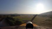
By: Big Orange Bird


