Login
Register
LGD
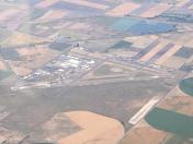
La Grande/Union County Airport
Official FAA Data Effective 2024-10-31 0901Z
VFR Chart of KLGD
Sectional Charts at SkyVector.com
IFR Chart of KLGD
Enroute Charts at SkyVector.com
Location Information for KLGD
Coordinates: N45°17.34' / W118°0.37'Located 04 miles SE of La Grande, Oregon on 640 acres of land. View all Airports in Oregon.
Surveyed Elevation is 2717 feet MSL.
Operations Data
|
|
Airport Communications
| AWOS-3PT: | 135.075 Tel. 541-963-6824 |
|---|---|
| CTAF: | 122.800 |
| UNICOM: | 122.800 |
| ASOS at BKE (28.4 S): | 134.275 541-523-5412 |
| AWOS-3P at JSY (32.0 E): | 123.775 541 432 0458 |
| ASOS at PDT (42.8 NW): | 118.325 541-278-2329 |
- APCH/DEP CTL SVC PRVDD BY SEATTLE ARTCC (ZSE) ON FREQS 132.6/269.35 (WALLULA RCAG).
Nearby Navigation Aids
|
| ||||||||||||||||||||||||||||||||||||||||||||||||
Runway 12/30
| Dimensions: | 6261 x 100 feet / 1908 x 30 meters | |
|---|---|---|
| Surface: | Asphalt in Good Condition | |
| Weight Limits: | S-65, D-90, ST-130 | |
| Edge Lighting: | Medium Intensity | |
| Runway 12 | Runway 30 | |
| Coordinates: | N45°17.73' / W118°0.72' | N45°17.00' / W117°59.69' |
| Elevation: | 2717.6 | 2706.8 |
| Traffic Pattern: | Left | Left |
| Runway Heading: | 135° True | 315° True |
| Displaced Threshold: | 760 Feet | |
| Declared Distances: | TORA:6261 TODA:6261 | TORA:6261 TODA:6261 |
| Markings: | Non-Precision Instrument in good condition. | Non-Precision Instrument in good condition. |
| Glide Slope Indicator | P2L (3.00° Glide Path Angle) PAPI RWY 12 DOES NOT PRVD OBSTN CLNC BYD 6.0 NM. | P2L (3.00° Glide Path Angle) |
| REIL: | Yes | |
| Obstacles: | 15 ft Road 335 ft from runway RUNWAY 12 OBSTRUCTION CLEARANCE SLOPE 72:1 BASED ON DISPLACED THRESHOLD |
|
Runway 17/35
| Dimensions: | 3400 x 75 feet / 1036 x 23 meters | |
|---|---|---|
| Surface: | Asphalt in Good Condition | |
| Weight Limits: | S-45, D-60, ST-100 | |
| Edge Lighting: | Medium Intensity | |
| Runway 17 | Runway 35 | |
| Coordinates: | N45°17.58' / W118°0.67' | N45°17.02' / W118°0.67' |
| Elevation: | 2713.8 | 2709.1 |
| Traffic Pattern: | Left | Left |
| Runway Heading: | 180° True | 360° True |
| Markings: | Non-Precision Instrument in good condition. | Non-Precision Instrument in good condition. |
| Glide Slope Indicator | P4L (3.00° Glide Path Angle) | |
| REIL: | Yes | Yes |
Services Available
| Fuel: | 100LL (blue), Jet-A |
|---|---|
| Transient Storage: | Hangars,Tiedowns CTC IN ADVN FOR HNGR STORAGE. |
| Airframe Repair: | MAJOR |
| Engine Repair: | MAJOR |
| Bottled Oxygen: | NONE |
| Bulk Oxygen: | NOT AVAILABLE |
| Other Services: | CROP DUSTING SERVICES,AIR AMBULANCE SERVICES,PILOT INSTRUCTION |
Ownership Information
| Ownership: | Publicly owned | |
|---|---|---|
| Owner: | UNION COUNTY | |
| 1106 K AVENUE | ||
| LA GRANDE, OR 97850 | ||
| 514-963-1016 | ||
| Manager: | DOUG WRIGHT | |
| 60175 PIERCE ROAD | ||
| LA GRANDE, OR 97850 | ||
| 541-963-6615 | ||
Other Remarks
- EXTSV FOREST SVC OPNS DURG SUMMER MOS.
- FBO & FUELING LCTD WEST OF RWY 17/35
- COLD TEMPERATURE AIRPORT. ALTITUDE CORRECTION REQUIRED AT OR BELOW -17C.
- FOR CD IF UNA TO CTC ON FSS FREQ, CTC SEATTLE ARTCC AT 253-351-3694.
- AFTER HOURS CALL OUT LIST POSTED ON DOOR.
- ACTVT REIL RWY 17 & 35; PAPI RWY 17; MIRL RWY 12/30 & 17/35 - CTAF.
Weather Minimums
Instrument Approach Procedure (IAP) Charts
Departure Procedure Obstacles (DPO) Charts
Nearby Airports with Instrument Procedures
| ID | Name | Heading / Distance | ||
|---|---|---|---|---|
 |
KBKE | Baker City Municipal Airport | 162° | 28.4 |
 |
KJSY | Joseph State Airport | 082° | 32.1 |
 |
KPDT | Eastern Oregon Regional At Pendleton Airport | 304° | 42.9 |
 |
KALW | Walla Walla Regional Airport | 346° | 49.6 |
 |
KHRI | Hermiston Municipal Airport | 301° | 61.9 |
 |
KGCD | Grant County Regional/Ogilvie Field Airport | 218° | 67.2 |
 |
9S9 | Lexington Airport | 278° | 71.9 |
 |
KPSC | Tri-Cities Airport | 321° | 74.9 |
 |
KLWS | Lewiston/Nez Perce County Airport | 032° | 77.3 |
 |
S87 | Weiser Municipal Airport | 145° | 78.9 |
 |
KRLD | Richland Airport | 318° | 81.8 |
 |
KMYL | Mc Call Municipal Airport | 105° | 84.4 |


