Login
Register


LIT
Bill and Hillary Clinton Ntl/Adams Field Airport
Official FAA Data Effective 2025-11-27 0901Z
From the Flight Deck
Chart Supplement

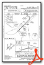
KLIT Airport Diagram

VFR Chart of KLIT
Sectional Charts at SkyVector.com
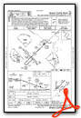
IFR Chart of KLIT
Enroute Charts at SkyVector.com
Location Information for KLIT
Coordinates: N34°43.77' / W92°13.49'Located 02 miles E of Little Rock, Arkansas on 2000 acres of land. View all Airports in Arkansas.
Surveyed Elevation is 266 feet MSL.
Operations Data
|
|
Airport Communications
| D-ATIS: | 125.65 (501-379-2915) |
|---|---|
| ASOS: | Tel. 501-376-0247 |
| ADAMS TOWER: | 118.7 257.8 |
| ADAMS GROUND: | 121.9 339.8 |
| LITTLE ROCK APPROACH: | 119.5 ;240-039 135.4 ;040-239 291.775 306.2 ;240-039 353.6 ;040-239 |
| LITTLE ROCK DEPARTURE: | 119.5 ;240-039 135.4 ;040-239 306.2 ;240-039 353.6 ;040-239 |
| IC: | 135.4 ;040-239 353.6 ;040-239 |
| CLEARANCE DELIVERY: | 118.95 |
| UNICOM: | 122.950 |
| PRE TAXI CLNC: | 118.95 |
| EMERG: | 121.5 243.0 |
| CLASS C: | 119.5 ;240-039 135.4 ;040-239 306.2 ;240-039 353.6 ;040-239 |
| AWOS-3PT at ORK (6.4 N): | 123.775 501-906-6529 |
| ATIS at LRF (12.0 N): | 251.1 |
| AWOS-3 at SUZ (15.3 SW): | 132.125 501-847-3883 |
Nearby Navigation Aids
|
| ||||||||||||||||||||||||||||||||||||||||||||||||


Runway 04L/22R
| Dimensions: | 8273 x 150 feet / 2522 x 46 meters | |
|---|---|---|
| Surface: | Concrete / Grooved in Good Condition | |
| Weight Limits: | S-75, D-200, ST-350
PCR VALUE: 865/R/B/W/T
| |
| Edge Lighting: | High Intensity | |
| Runway 04L | Runway 22R | |
| Coordinates: | N34°43.35' / W92°14.28' | N34°44.29' / W92°13.08' |
| Elevation: | 253.0 | 261.5 |
| Traffic Pattern: | Left | Right |
| Runway Heading: | 47° True | 227° True |
| Displaced Threshold: | 297 Feet | |
| Declared Distances: | TORA:8273 TODA:8273 ASDA:8273 LDA:7976 | TORA:8273 TODA:8273 ASDA:8273 LDA:8273 |
| Markings: | Precision Instrument in good condition. | Precision Instrument in good condition. |
| Glide Slope Indicator | P4L (3.00° Glide Path Angle) | P4R (3.00° Glide Path Angle) |
| RVR Equipment | Touchdown Midfield Rollout | Touchdown Midfield Rollout |
| Approach Lights: | MALSR 1,400 Foot Medium-intensity Approach Lighting System with runway alignment indicator lights. | ALSF2 Standard 2,400 Foot High-intensity Approach Lighting System with sequenced flashers, CATEGORY II or III Configuration. |
| Centerline Lights: | Yes | Yes |
| Obstacles: | 23 ft Railroad 670 ft from runway, 557 ft left of center APCH RATIO 42:1 FM DSPLCD THLD. |
|
Runway 04R/22L
| Dimensions: | 8251 x 150 feet / 2515 x 46 meters | |
|---|---|---|
| Surface: | Concrete / Grooved in Good Condition | |
| Weight Limits: | S-75, D-200, ST-350
PCR VALUE: 719/R/A/W/T
| |
| Edge Lighting: | High Intensity | |
| Runway 04R | Runway 22L | |
| Coordinates: | N34°43.16' / W92°13.27' | N34°44.10' / W92°12.08' |
| Elevation: | 266.0 | 259.4 |
| Traffic Pattern: | Right | |
| Runway Heading: | 47° True | 227° True |
| Displaced Threshold: | 1050 Feet | |
| Declared Distances: | TORA:8250 TODA:8250 ASDA:8250 LDA:7200 | TORA:7200 TODA:7200 ASDA:7200 LDA:7200 |
| Markings: | Precision Instrument in good condition. | Precision Instrument in good condition. |
| Glide Slope Indicator | P4R (3.00° Glide Path Angle) | P4L (3.00° Glide Path Angle) |
| RVR Equipment | Touchdown Rollout | Touchdown Rollout |
| Approach Lights: | MALSR 1,400 Foot Medium-intensity Approach Lighting System with runway alignment indicator lights. | MALSF 1,400 Foot Medium-intensity Approach Lighting System with sequenced flashers. |
| Centerline Lights: | Yes | Yes |
| Obstacles: | 78 ft Pole 2874 ft from runway, 820 ft right of center | 72 ft Trees 3301 ft from runway, 754 ft right of center |
Runway 18/36
| Dimensions: | 6224 x 150 feet / 1897 x 46 meters | |
|---|---|---|
| Surface: | Concrete / Grooved in Good Condition | |
| Weight Limits: | S-75, D-100, ST-135
PCR VALUE: 347/R/B/W/T
| |
| Edge Lighting: | Medium Intensity | |
| Runway 18 | Runway 36 | |
| Coordinates: | N34°44.39' / W92°14.29' | N34°43.36' / W92°14.32' |
| Elevation: | 258.9 | 253.3 |
| Traffic Pattern: | Left | Left |
| Runway Heading: | 182° True | 2° True |
| Displaced Threshold: | 164 Feet | |
| Declared Distances: | TORA:6060 TODA:6060 ASDA:6060 LDA:6060 | TORA:6224 TODA:6224 ASDA:6224 LDA:6060 |
| Markings: | Non-Precision Instrument in good condition. | Non-Precision Instrument in good condition. |
| Glide Slope Indicator | P4L (3.00° Glide Path Angle) | P4R (3.75° Glide Path Angle) |
| Obstacles: | 35 ft Tree 1286 ft from runway, 164 ft left of center APCH RATIO 39:1 BASED ON DSPLCD THLD +35 FT TREE 1385 FT DIST 164 FT LEFT. |
105 ft Trees 2489 ft from runway, 351 ft right of center APCH RATIO 24:1 BASED ON DSPLCD THLD; 105 FT TREES 2579 FT DIST 351 FT R. |
Services Available
| Fuel: | 100LL (blue), Jet-A |
|---|---|
| Transient Storage: | Hangars,Tiedowns |
| Airframe Repair: | MAJOR |
| Engine Repair: | MAJOR |
| Bottled Oxygen: | HIGH |
| Bulk Oxygen: | HIGH |
| Other Services: | AIR FREIGHT SERVICES,AIR AMBULANCE SERVICES,AVIONICS,CARGO HANDLING SERVICES,CHARTER SERVICE,PILOT INSTRUCTION,AIRCRAFT RENTAL,AIRCRAFT SALES,ANNUAL SURVEYING |
Ownership Information
| Ownership: | Publicly owned | |
|---|---|---|
| Owner: | CITY OF LITTLE ROCK | |
| 1 AIRPORT DRIVE | ||
| LITTLE ROCK, AR 72202 | ||
| 501-372-3439 | ||
| Manager: | STEVEN C. BAKER | |
| 1 AIRPORT DRIVE | ||
| LITTLE ROCK, AR 72202 | ||
| 501-537-7311 | OPNS DIR | |
Other Remarks
- LARGE CONCENTRATIONS OF BIRDS INVOF ARPT; MOST ACTIVITY BTN SR-SS UP TO 1500 FT MSL.
- FOR CD WHEN UNA VIA FREQ CTC LITTLE ROCK APCH 501-379-2908 OR LITTLE ROCK ATCT 501-379-2911.
- SMGCS SUSPENDED UFN.
- PSGR ACR ACFT ADG-IV AND HYR RESTRICTED FROM USING TWY F BTN TWY E AND ATLANTIC AVN/ENVOY HNGR RAMP DUE TO NON-STD SAFETY AREA
- CARGO & TERMINAL RAMPS ARE NON-MOVEMENT AREAS.
- NO GENERAL AVIATION PARKING ON TERMINAL OR CARGO RAMP.
- TWY A 315 FT SOUTH OF TWY A6 INTERSECTION TO RWY 36 CLSD EXCEPT ACFT WITH WINGSPAN LESS THAN 79 FT.
- BE ALERT: NORTH LITTLE ROCK MUNI AIRPORT IS LCTD 6 MILES NNW WITH SIMILAR RUNWAY CONFIGURATIONS.
- ENGINEERED MATERIALS ARRESTING SYSTEM (EMAS) 262.6 FT IN LENGTH BY 169.7 FT IN WIDTH LCTD AT THE DER 22R.
Weather Minimums


Instrument Approach Procedure (IAP) Charts


Nearby Airports with Instrument Procedures
| ID | Name | Heading / Distance | ||
|---|---|---|---|---|
 |
KORK | North Little Rock Municipal Airport | 346° | 6.4 |
|
KLRF | Little Rock AFB Airport | 019° | 11.9 |
|
KSUZ | Saline County Regional Airport | 236° | 15.1 |
|
KCXW | Conway Regional Airport | 316° | 23.8 |
|
9M8 | Sheridan-Grant County Regional Airport | 194° | 24.9 |
|
4M3 | Carlisle Municipal Airport | 079° | 25.8 |
|
KSGT | Stuttgart Municipal Carl Humphrey Field Airport | 103° | 33.1 |
|
KBDQ | Morrilton Municipal Airport | 315° | 34.3 |
|
M78 | Malvern Municipal Airport | 228° | 35.6 |
|
KPBF | Pinebluff Regional/Grider Field Airport | 156° | 36.2 |
|
KSRC | Searcy Regional Airport | 039° | 37.5 |
|
KMPJ | Petit Jean Park Airport | 306° | 41.7 |
Airport Images

By: Dave


