Login
Register


LRY
Lawrence Smith Memorial Airport
Official FAA Data Effective 2026-01-22 0901Z
Chart Supplement

VFR Chart of KLRY
Sectional Charts at SkyVector.com
IFR Chart of KLRY
Enroute Charts at SkyVector.com
Location Information for KLRY
Coordinates: N38°36.61' / W94°20.61'Located 03 miles S of Harrisonville, Missouri on 126 acres of land. View all Airports in Missouri.
Surveyed Elevation is 915 feet MSL.
Operations Data
|
|
Airport Communications
| AWOS-3PT: | 119.975 Tel. 816-380-5936 |
|---|---|
| CTAF: | 122.900 |
| ASOS at LXT (20.9 N): | 124.175 816-347-9807 |
| ATIS at OJC (23.3 NW): | 119.35 |
| ASOS at OJC (23.3 NW): | 913-780-6969 |
- APCH/DEP SVC PRVDD BY KANSAS CITY ARTCC ON FREQS 125.55/327.0 (BUTLER RCAG).
Nearby Navigation Aids
|
| ||||||||||||||||||||||||||||||||||||||||||||||||||||||


Runway 17/35
| Dimensions: | 4000 x 75 feet / 1219 x 23 meters | |
|---|---|---|
| Surface: | Concrete in Excellent Condition | |
| Weight Limits: | S-29, D-38 | |
| Edge Lighting: | Medium Intensity | |
| Runway 17 | Runway 35 | |
| Coordinates: | N38°36.94' / W94°20.63' | N38°36.28' / W94°20.59' |
| Elevation: | 915.4 | 874.6 |
| Traffic Pattern: | Left | |
| Runway Heading: | 177° True | 357° True |
| Declared Distances: | TORA:4000 TODA:4000 ASDA:4000 LDA:4000 | TORA:4000 TODA:4000 ASDA:4000 LDA:4000 |
| Markings: | Non-Precision Instrument in good condition. | Non-Precision Instrument in good condition. |
| Glide Slope Indicator | P2L (4.00° Glide Path Angle) | P2L (3.00° Glide Path Angle) |
| REIL: | Yes | Yes |
| Obstacles: | 73 ft Trees 1115 ft from runway, 335 ft left of center | 27 ft Trees 340 ft from runway, 200 ft left of center |
Services Available
| Fuel: | 100LL (blue) |
|---|---|
| Transient Storage: | Tiedowns |
| Airframe Repair: | MINOR |
| Engine Repair: | MINOR |
| Bottled Oxygen: | NONE |
| Bulk Oxygen: | NONE |
| Other Services: | CROP DUSTING SERVICES,AIR AMBULANCE SERVICES,PILOT INSTRUCTION,AIRCRAFT RENTAL |
Ownership Information
| Ownership: | Publicly owned | |
|---|---|---|
| Owner: | CITY OF HARRISONVILLE | |
| PO BOX 367 | ||
| HARRISONVILLE, MO 64701 | ||
| 816-380-8900 | ||
| Manager: | MICHAEL NEWMAN | |
| PO BOX 367 | ||
| HARRISONVILLE, MO 64701 | ||
| (660) 422-2090 | ||
Other Remarks
- ULTRALIGHTS ON & INVOF ARPT.
- AIR AMBULANCE HELICOPTER OPS ON AND INVOF ARPT.
- FOR CD CTC KANSAS CITY APCH AT 816-329-2710.
- DEER AND OTHER WILDFLIFE ON AND INVOF ARPT.
- 0LL 24-HR SELF SVC FUEL.
- ACTVT REIL RWY 17 & 35; PAPI RWY 17 & 35; MIRL RWY 17/35 - CTAF.
Weather Minimums


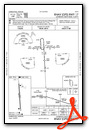
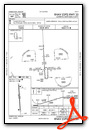
Instrument Approach Procedure (IAP) Charts
Nearby Airports with Instrument Procedures
| ID | Name | Heading / Distance | ||
|---|---|---|---|---|
 |
KBUM | Butler Memorial Airport | 179° | 19.2 |
|
KLXT | Kansas City/Lee's Summit Regional Airport | 356° | 21.0 |
|
KOJC | Johnson County Exec Airport | 307° | 23.3 |
|
3GV | East Kansas City Airport | 013° | 25.0 |
|
K81 | Miami County Airport | 261° | 27.5 |
|
KRCM | Skyhaven Airport | 067° | 27.5 |
|
KIXD | New Century Aircenter Airport | 297° | 28.9 |
|
KMKC | Kansas City Downtown/Wheeler Field Airport | 339° | 32.9 |
|
KGLY | Clinton Regional Airport | 115° | 34.8 |
|
KSZL | Whiteman AFB Airport | 078° | 38.1 |
|
KHIG | Higginsville Industrial Municipal Airport | 048° | 41.7 |
|
KOWI | Ottawa Municipal Airport | 264° | 43.0 |
Airport Images
Do you have a recent image of this airport? Upload it here!


