Login
Register


M91
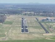
Springfield Robertson County Airport
Official FAA Data Effective 2026-02-19 0901Z
Chart Supplement

VFR Chart of M91
Sectional Charts at SkyVector.com
IFR Chart of M91
Enroute Charts at SkyVector.com
Location Information for M91
Coordinates: N36°32.20' / W86°55.27'Located 03 miles NW of Springfield, Tennessee on 148 acres of land. View all Airports in Tennessee.
Surveyed Elevation is 706 feet MSL.
Operations Data
|
|
Airport Communications
| AWOS-3: | 120.675 Tel. 615-656-5333 |
|---|---|
| NASHVILLE APPROACH: | 119.35 372.0 |
| NASHVILLE DEPARTURE: | 119.35 372.0 |
| CTAF: | 123.000 |
| UNICOM: | 123.000 |
| AWOS-3 at JWN (21.2 S): | 615-350-6222 |
| ATIS at JWN (21.3 S): | 127.075 |
| AWOS-3PT at 1M5 (21.7 E): | 118.175 615-325-4971 |
Nearby Navigation Aids
|
| ||||||||||||||||||||||||||||||||||||||||||||||||||||||||||||


Runway 04/22
| Dimensions: | 5505 x 100 feet / 1678 x 30 meters | |
|---|---|---|
| Surface: | Asphalt in Good Condition | |
| Weight Limits: | 7 /F/D/X/T, S-19 | |
| Edge Lighting: | Medium Intensity | |
| Runway 04 | Runway 22 | |
| Coordinates: | N36°31.82' / W86°55.58' | N36°32.58' / W86°54.96' |
| Elevation: | 700.5 | 706.3 |
| Traffic Pattern: | Left | |
| Runway Heading: | 34° True | 214° True |
| Markings: | Non-Precision Instrument in good condition. | Non-Precision Instrument in good condition. |
| Glide Slope Indicator | P2L (3.00° Glide Path Angle) | P2L (3.00° Glide Path Angle) |
| REIL: | Yes | Yes |
| Obstacles: | 70 ft Tree 2196 ft from runway, 429 ft right of center | 62 ft Tree 1147 ft from runway, 234 ft left of center |
Services Available
| Fuel: | 100LL (blue), Jet A+ |
|---|---|
| Transient Storage: | Hangars,Tiedowns |
| Airframe Repair: | MAJOR |
| Engine Repair: | MAJOR |
| Bottled Oxygen: | NOT AVAILABLE |
| Bulk Oxygen: | NOT AVAILABLE |
| Other Services: | PILOT INSTRUCTION,AIRCRAFT RENTAL |
Ownership Information
| Ownership: | Publicly owned | |
|---|---|---|
| Owner: | SPRINGFIELD/ROBERTSON AIRPORT BOARD | |
| P.O.BOX 1125 | ||
| SPRINGFIELD, TN 37172-1125 | ||
| 615-985-4432 | ||
| Manager: | BRIAN URBACH | |
| 4432 AIRPORT RD | ||
| SPRINGFIELD, TN 37172 | ||
| 615-985-4432 | ||
Other Remarks
- FOR CD CTC NASHVILLE APCH AT 615-695-4524.
- DEP CLIMB TO 500 FT BFR TURN.
- FLT TRNG INVOF ARPT.
- AFT HR ACES - UNICOM.
- CREDIT CARD FUEL AVBL H24.
- CALM WIND RWY.
- ACTVT REIL RWY 04 & 22; MIRL RWY 04/22 - CTAF. MIRL RWY 04/22 PRESET TO LOW INTST; INCR INTST - CTAF.
Weather Minimums

Instrument Approach Procedure (IAP) Charts


Nearby Airports with Instrument Procedures
| ID | Name | Heading / Distance | ||
|---|---|---|---|---|
 |
4M7 | Russellville-Logan County Airport | 018° | 16.6 |
|
KJWN | John C Tune Airport | 175° | 21.3 |
|
1M5 | Douglas Hunter Field Airport | 080° | 21.7 |
|
KCKV | Outlaw Field Airport | 282° | 24.4 |
|
KXNX | Music City Exec Airport | 111° | 26.6 |
|
KBNA | Nashville International Airport | 154° | 27.4 |
|
KHOP | Campbell AAF (Fort Campbell) Airport | 286° | 28.8 |
|
KHVC | Hopkinsville-Christian County Airport | 306° | 32.1 |
|
M02 | Dickson Municipal Airport | 225° | 34.8 |
|
KBWG | Bowling Green-Warren County Regional Airport | 043° | 35.2 |
|
M54 | Lebanon Municipal Airport | 125° | 35.9 |
|
KMQY | Smyrna Airport | 148° | 37.1 |