Login
Register


M15
James Tucker Airport
Official FAA Data Effective 2026-01-22 0901Z
Chart Supplement

VFR Chart of M15
Sectional Charts at SkyVector.com
IFR Chart of M15
Enroute Charts at SkyVector.com
Location Information for M15
Coordinates: N35°35.69' / W87°52.60'Located 03 miles SW of Linden, Tennessee on 75 acres of land. View all Airports in Tennessee.
Estimated Elevation is 740 feet MSL.
Operations Data
|
|
Airport Communications
| CTAF: | 122.900 |
|---|---|
| AWOS-3 at PVE (15.9 W): | 118.125 731-845-5738 |
| AWOS-3 at SNH (30.2 SW): | 133.925 731-925-6080 |
| AWOS-3 at MRC (34.2 E): | 128.625 931-379-0844 |
Nearby Navigation Aids
|
| ||||||||||||||||||||||||||||||||||||||||||||||||||||||


Runway 18/36
| Dimensions: | 3600 x 75 feet / 1097 x 23 meters | |
|---|---|---|
| Surface: | Asphalt in Fair Condition | |
| Weight Limits: | S-17 | |
| Edge Lighting: | Medium Intensity | |
| Runway 18 | Runway 36 | |
| Coordinates: | N35°35.99' / W87°52.61' | N35°35.39' / W87°52.59' |
| Elevation: | 738.0 | 710.0 |
| Traffic Pattern: | Left | Left |
| Runway Heading: | 178° True | 358° True |
| Displaced Threshold: | 140 Feet | 117 Feet |
| Declared Distances: | TORA:3600 TODA:3600 LDA:3460 | TORA:3600 TODA:3600 LDA:3483 |
| Markings: | Basic in fair condition. | Basic in fair condition. |
| Glide Slope Indicator | P2L | P2L |
| REIL: | Yes | Yes |
| Obstacles: | CTLG OBSTN EXCEEDS 45 DEG SLP. |
21 ft Trees 207 ft from runway, 55 ft left of center |
Services Available
| Fuel: | NONE |
|---|---|
| Transient Storage: | Tiedowns |
| Airframe Repair: | NONE |
| Engine Repair: | NONE |
| Bottled Oxygen: | NONE |
| Bulk Oxygen: | NONE |
Ownership Information
| Ownership: | Publicly owned | |
|---|---|---|
| Owner: | PERRY COUNTY | |
| COUNTY COURTHOUSE PO BOX 16 | ||
| LINDEN, TN 37096 | ||
| 931-589-2216 | ||
| Manager: | BOB OUSLEY | |
| COUNTY COURTHOUSE, P.O. BOX 16 | PHYSICAL AIRPORT ADDRESS IS 799 AIRPORT RD., LINDEN, TN 37096 | |
| LINDEN, TN 37096 | ||
| (615) 513-5852 | ||
Other Remarks
- FOR CD CTC MEMPHIS ARTCC AT 901-368-8453/8449.
Nearby Airports with Instrument Procedures
| ID | Name | Heading / Distance | ||
|---|---|---|---|---|
 |
0M3 | Paul Bridges Field Airport | 102° | 14.0 |
|
KPVE | Beech River Regional Airport | 283° | 16.0 |
|
KGHM | Centerville Municipal Airport | 055° | 25.6 |
|
0M4 | Benton County Airport | 334° | 27.6 |
|
KSNH | Savannah-Hardin County Airport | 213° | 30.4 |
|
0M5 | Humphreys County Airport | 012° | 32.0 |
|
KMRC | Maury County Regional Airport | 093° | 34.2 |
|
2M2 | Lawrenceburg/Lawrence County (Fleeman Field) Airport | 125° | 37.2 |
|
KSZY | Robert Sibley Airport | 232° | 38.5 |
|
M02 | Dickson Municipal Airport | 034° | 38.7 |
|
KHZD | Sgt Lee Russell Carroll County Airport | 316° | 41.2 |
|
KGZS | Abernathy Field Airport | 123° | 48.1 |
Airport Images
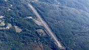
By: val.foreit

By: Big Orange Bird


