Login
Register


M22
Bill Pugh Field Airport
Official FAA Data Effective 2026-01-22 0901Z
Chart Supplement

VFR Chart of M22
Sectional Charts at SkyVector.com
IFR Chart of M22
Enroute Charts at SkyVector.com
Location Information for M22
Coordinates: N34°26.70' / W87°42.70'Located 03 miles SE of Russellville, Alabama on 177 acres of land. View all Airports in Alabama.
Surveyed Elevation is 717 feet MSL.
Operations Data
|
|
Airport Communications
| UNICOM: | 122.800 |
|---|---|
| CTAF: | 122.800 |
| AWOS-3PT at 1M4 (11.2 SE): | 119.525 205-486-0035 |
| ASOS at MSL (18.7 N): | 119.425 256-383-2304 |
| AWOS-3P at 9A4 (22.1 NE): | 118.525 256-637-0903 |
- APCH/DEP SVC PRVDD BY MEMPHIS ARTCC ON FREQS 120.8/307.0 (HUNTSVILLE RCAG).
Nearby Navigation Aids
|
| ||||||||||||||||||||||||||||||||||||||||||||||||||||||||||||


Runway 02/20
| Dimensions: | 5500 x 75 feet / 1676 x 23 meters | |
|---|---|---|
| Surface: | Asphalt in Fair Condition | |
| Weight Limits: | S-120, D-225, ST-250, DT-1096
PCR VALUE: 903/F/C/X/T
| |
| Edge Lighting: | Medium Intensity | |
| Runway 02 | Runway 20 | |
| Coordinates: | N34°26.27' / W87°42.85' | N34°27.14' / W87°42.55' |
| Elevation: | 687.4 | 717.6 |
| Runway Heading: | 16° True | 196° True |
| Displaced Threshold: | 500 Feet | |
| Declared Distances: | TORA:5000 TODA:5000 ASDA:5500 LDA:5500 | TORA:5500 TODA:5500 ASDA:5500 LDA:5000 |
| Markings: | Non-Precision Instrument in good condition. | Non-Precision Instrument in good condition. |
| Glide Slope Indicator | P4L (3.00° Glide Path Angle) | |
| REIL: | Yes | Yes |
| Obstacles: | 20 ft Trees 469 ft from runway, 117 ft left of center | APCH SLP 29:1 TO DTHR. |
Services Available
| Fuel: | 100LL (blue), Jet-A |
|---|---|
| Transient Storage: | Tiedowns |
| Airframe Repair: | NONE |
| Engine Repair: | NONE |
| Bottled Oxygen: | NONE |
| Bulk Oxygen: | NONE |
| Other Services: | PILOT INSTRUCTION,AIRCRAFT RENTAL |
Ownership Information
| Ownership: | Publicly owned | |
|---|---|---|
| Owner: | CITY OF RUSSELLVILLE | |
| PO BOX 1000 | ||
| RUSSELLVILLE, AL 35653 | ||
| 256-332-6060 | ||
| Manager: | EMILY EVANS | |
| 13365 HWY 243 | ||
| RUSSELLVILLE, AL 35654-7605 | ||
| 256-412-5225 | ARPT NR 256-331-9000. | |
Other Remarks
- FOR CD CTC MEMPHIS ARTCC AT 901-368-8453/8449.
- ACTVT REIL RWY 02 & 20; PAPI RWY 20; MIRL RWY 02/20 - CTAF.
Weather Minimums

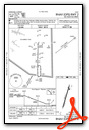
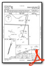
Instrument Approach Procedure (IAP) Charts
Nearby Airports with Instrument Procedures
| ID | Name | Heading / Distance | ||
|---|---|---|---|---|
 |
1M4 | Posey Field Airport | 150° | 11.3 |
|
KMSL | Northwest Alabama Regional Airport | 015° | 18.7 |
|
9A4 | Courtland Airport | 054° | 22.1 |
|
KHAB | Marion County-Rankin Fite Airport | 216° | 24.3 |
|
15M | Segars Field Airport | 311° | 29.9 |
|
KJFX | Walker County/Bevill Field Airport | 148° | 38.1 |
|
5M0 | Hartselle/Morgan County Regional Airport | 093° | 38.7 |
|
KDCU | Pryor Field Regional Airport | 071° | 40.0 |
|
M55 | Lamar County Airport | 209° | 41.1 |
|
KCMD | Cullman Regional/Folsom Field Airport | 103° | 43.7 |
|
M95 | Richard Arthur Field Airport | 186° | 44.4 |
|
8M1 | Booneville/Baldwyn Airport | 280° | 47.3 |
Fuel Providers

Airport Images
Do you have a recent image of this airport? Upload it here!


