Login
Register


UBS
Columbus-Lowndes County Airport
Official FAA Data Effective 2026-01-22 0901Z
Chart Supplement

VFR Chart of KUBS
Sectional Charts at SkyVector.com
IFR Chart of KUBS
Enroute Charts at SkyVector.com
Location Information for KUBS
Coordinates: N33°27.92' / W88°22.85'Located 03 miles SE of Columbus, Mississippi on 215 acres of land. View all Airports in Mississippi.
Surveyed Elevation is 188 feet MSL.
Operations Data
|
|
Airport Communications
| COLUMBUS APPROACH: | 135.6 323.275 |
|---|---|
| COLUMBUS DEPARTURE: | 135.6 323.275 |
| CTAF: | 122.800 |
| UNICOM: | 122.800 |
| AWOS-3PT at GTR (10.6 W): | 126.375 662-328-7798 |
| ATIS at GTR (10.6 W): | 126.375 |
| ASOS at CBM (11.3 N): | 354.6 |
- APCH/DEP SVC PRVDD BY MEMPHIS ARTCC (COLUMBUS RCAG) ON FREQS 127.1/269.4 WHEN COLUMBUS APCH CTL CLSD.
Nearby Navigation Aids
|
| ||||||||||||||||||||||||||||||||||||||||||||||||||||||


Runway 18/36
| Dimensions: | 4503 x 100 feet / 1373 x 30 meters | |
|---|---|---|
| Surface: | Asphalt in Excellent Condition | |
| Weight Limits: | S-40, D-70, ST-120 | |
| Edge Lighting: | Medium Intensity | |
| Runway 18 | Runway 36 | |
| Coordinates: | N33°28.29' / W88°22.85' | N33°27.55' / W88°22.84' |
| Elevation: | 188.0 | 184.6 |
| Traffic Pattern: | Left | Left |
| Runway Heading: | 179° True | 359° True |
| Markings: | Non-Precision Instrument in good condition. | Non-Precision Instrument in good condition. |
| Glide Slope Indicator | P2L (3.00° Glide Path Angle) | P2L (3.00° Glide Path Angle) OTS UFN. |
| Obstacles: | 68 ft Trees 2510 ft from runway, 300 ft left of center | 67 ft Trees 2075 ft from runway |
Services Available
| Fuel: | 100LL (blue), Jet A+ |
|---|---|
| Transient Storage: | Hangars,Tiedowns CALL AHEAD FOR HNGR SPACE. |
| Airframe Repair: | MINOR |
| Engine Repair: | MINOR |
| Bottled Oxygen: | NONE |
| Bulk Oxygen: | NONE |
| Other Services: | AIR AMBULANCE SERVICES,PILOT INSTRUCTION |
Ownership Information
| Ownership: | Publicly owned | |
|---|---|---|
| Owner: | CITY OF COLUMBUS & LOWNDES COUNTY | |
| 523 MAIN ST, PO BOX 1408 | ||
| COLUMBUS, MS 39703 | ||
| 662-328-7021 | ||
| Manager: | DAN DUSTON | |
| 368 FABRITEK DR | ||
| COLUMBUS, MS 39702 | ||
| 662-251-4650 | ||
Other Remarks
- FOR CD CTC MEMPHIS ARTCC AT 901-368-8453/8449.
- COURTESY CAR AVBL.
- 0LL FUEL AVBL 24 HRS WITH CREDIT CARD.
- MIRL RWY 18/36 OPR DUSK - 2200; AFT 2200 ACTVT - CTAF. PAPI RWY 18 & 36 OPR CONSLY.
Weather Minimums
Instrument Approach Procedure (IAP) Charts
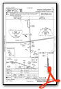
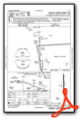

Nearby Airports with Instrument Procedures
| ID | Name | Heading / Distance | ||
|---|---|---|---|---|
 |
KGTR | Golden Triangle Regional Airport | 264° | 10.6 |
|
KCBM | Columbus AFB Airport | 343° | 11.3 |
|
M51 | Oktibbeha Airport | 277° | 15.2 |
|
M83 | Mccharen Field Airport | 296° | 16.0 |
|
3M8 | North Pickens Airport | 103° | 19.4 |
|
KAIV | George Downer Airport | 156° | 23.4 |
|
KSTF | George M Bryan Airport | 265° | 23.6 |
|
M40 | Monroe County Airport | 347° | 25.1 |
|
M55 | Lamar County Airport | 030° | 26.4 |
|
M95 | Richard Arthur Field Airport | 062° | 31.9 |
|
5A4 | Okolona Municipal/Richard Stovall Field Airport | 332° | 37.2 |
|
KLMS | Louisville/Winston County Airport | 241° | 39.3 |
Airport Images
Do you have a recent image of this airport? Upload it here!


