Login
Register


STF
George M Bryan Airport
Official FAA Data Effective 2026-02-19 0901Z
Chart Supplement

VFR Chart of KSTF
Sectional Charts at SkyVector.com
IFR Chart of KSTF
Enroute Charts at SkyVector.com
Location Information for KSTF
Coordinates: N33°25.99' / W88°50.92'Located 03 miles SW of Starkville, Mississippi on 635 acres of land. View all Airports in Mississippi.
Surveyed Elevation is 332 feet MSL.
Operations Data
|
|
Airport Communications
| AWOS-3PT: | 118.975 Tel. 662-323-4966 |
|---|---|
| COLUMBUS APPROACH: | 135.6 323.275 |
| COLUMBUS DEPARTURE: | 135.6 323.275 |
| CLEARANCE DELIVERY: | 126.25 |
| CTAF: | 122.700 |
| UNICOM: | 122.700 |
| ATIS at GTR (12.9 E): | 126.375 |
| AWOS-3PT at GTR (12.9 E): | 126.375 662-328-7798 |
| AWOS-3PT at LMS (20.4 SW): | 118.325 |
- APCH/DEP SVC PRVDD BY MEMPHIS ARTCC (COLUMBUS RCAG) ON FREQS 127.1/269.4 WHEN COLUMBUS APCH CTL CLSD.
Nearby Navigation Aids
|
| ||||||||||||||||||||||||||||||||||||||||||||||||


Runway 18/36
| Dimensions: | 5550 x 150 feet / 1692 x 46 meters | |
|---|---|---|
| Surface: | Asphalt-Concrete in Good Condition | |
| Weight Limits: | S-25, D-30 | |
| Edge Lighting: | High Intensity | |
| Runway 18 | Runway 36 | |
| Coordinates: | N33°26.44' / W88°50.93' | N33°25.53' / W88°50.90' |
| Elevation: | 332.1 | 320.9 |
| Traffic Pattern: | Left | Left |
| Runway Heading: | 179° True | 359° True |
| Displaced Threshold: | 1379 Feet | |
| Markings: | Non-Precision Instrument in fair condition. | Non-Precision Instrument in fair condition. |
| Glide Slope Indicator | P2L (3.00° Glide Path Angle) | P2L (3.00° Glide Path Angle) |
| REIL: | Yes | |
| Obstacles: | 32 ft Sign 900 ft from runway, 150 ft left of center APCH RATIO 49:1 FM DTHR. |
|
Services Available
| Fuel: | 100LL (blue), Jet-A |
|---|---|
| Transient Storage: | Tiedowns PILOTS MUST PRVD TIEDOWN ROPES. |
| Airframe Repair: | MAJOR |
| Engine Repair: | MAJOR |
| Bottled Oxygen: | NONE |
| Bulk Oxygen: | NONE |
| Other Services: | GLIDER SERVICE,PILOT INSTRUCTION,AIRCRAFT RENTAL,GLIDER TOWING SERVICES |
Ownership Information
| Ownership: | Publicly owned | |
|---|---|---|
| Owner: | CITY OF STARKVILLE | |
| 101 LAMPKIN ST | ||
| STARKVILLE, MS 39759 | ||
| 662-323-2525 | ||
| Manager: | RODNEY LINCOLN | |
| PO BOX 1424 | ||
| STARKVILLE, MS 39760 | ||
| 662-418-5900 | ||
Other Remarks
- EXPERIMENTAL ACFT ON & INVOF ARPT.
- FOR CD CTC COLUMBUS APCH AT 662-434-3044.
- COURTESY CAR AVBL.
- FULL SVC AFT HRS - CTC AMGR. FUEL AVBL 24 HRS WITH CREDIT CARD.
- 0800-1630; AFT HR ACTVT REIL RWY 36; HIRL RWY 18/36 - CTAF. PAPI RWY 18 & 36 OPR CONSLY.
Weather Minimums


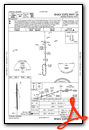
Instrument Approach Procedure (IAP) Charts


Nearby Airports with Instrument Procedures
| ID | Name | Heading / Distance | ||
|---|---|---|---|---|
 |
M51 | Oktibbeha Airport | 065° | 9.2 |
|
M83 | Mccharen Field Airport | 045° | 12.8 |
|
KGTR | Golden Triangle Regional Airport | 085° | 12.9 |
|
KLMS | Louisville/Winston County Airport | 212° | 20.3 |
|
KUBS | Columbus-Lowndes County Airport | 085° | 23.6 |
|
KCBM | Columbus AFB Airport | 057° | 23.9 |
|
M40 | Monroe County Airport | 034° | 31.9 |
|
5A4 | Okolona Municipal/Richard Stovall Field Airport | 009° | 35.4 |
|
KAIV | George Downer Airport | 120° | 38.2 |
|
KOSX | Kosciusko-Attala County Airport | 239° | 40.5 |
|
KMPE | Philadelphia Municipal Airport | 200° | 40.5 |
|
3M8 | North Pickens Airport | 093° | 42.4 |


Comments
KSTF
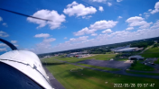
I stopped at Starkville MS for the overnight and ended up with bad bad weather the next day.
Having arrived after hours I found the self serve pumps and 24/7 terminal access both needed and welcoming.
The next day the staff at the city FBO put my airplane into the hanger and were super friendly and helpful at predicting the impending storm front arrival.
Dillon and Carson made sure that I got a rental and stayed after closing to help me on my way.
What a great airport you all have in Starkville. A rare Five Stars.
Pages