Login
Register


8V3
Parkston Municipal Airport
Official FAA Data Effective 2026-02-19 0901Z
Chart Supplement

VFR Chart of 8V3
Sectional Charts at SkyVector.com
IFR Chart of 8V3
Enroute Charts at SkyVector.com
Location Information for 8V3
Coordinates: N43°22.64' / W97°59.38'Located 01 miles SW of Parkston, South Dakota on 48 acres of land. View all Airports in South Dakota.
Estimated Elevation is 1418 feet MSL.
Operations Data
|
|
Airport Communications
| CTAF: | 122.900 |
|---|---|
| AWOS-3P at AGZ (23.1 SW): | 128.325 605-384-3922 |
| ASOS at MHE (23.9 N): | 124.175 605-995-5803 |
| AWOS-3PT at YKN (38.3 SE): | 119.05 605-665-6072 |
Nearby Navigation Aids
|
| ||||||||||||||||||||||||||||||||||||||||||||||||||||||||||||


Runway 15/33
| Dimensions: | 3600 x 60 feet / 1097 x 18 meters | |
|---|---|---|
| Surface: | Asphalt in Excellent Condition | |
| Weight Limits: | S-12, D-12 | |
| Edge Lighting: | Medium Intensity | |
| Runway 15 | Runway 33 | |
| Coordinates: | N43°22.91' / W97°59.56' | N43°22.38' / W97°59.20' |
| Elevation: | 1414.6 | 1418.3 |
| Traffic Pattern: | Left | Left |
| Markings: | Non-Precision Instrument in good condition. | Non-Precision Instrument in good condition. |
| Glide Slope Indicator | P2R (3.00° Glide Path Angle) | P2L (3.00° Glide Path Angle) |
| Obstacles: | 49 ft Pole 1240 ft from runway, 200 ft left of center | |
Services Available
| Fuel: | 100LL (blue), Jet-A |
|---|---|
| Transient Storage: | Tiedowns |
| Airframe Repair: | NOT AVAILABLE |
| Engine Repair: | NOT AVAILABLE |
| Bottled Oxygen: | NOT AVAILABLE |
| Bulk Oxygen: | NOT AVAILABLE |
| Other Services: | CROP DUSTING SERVICES |
Ownership Information
| Ownership: | Publicly owned | |
|---|---|---|
| Owner: | CITY OF PARKSTON | |
| PO BOX 490 | ||
| PARKSTON, SD 57366 | ||
| 605-928-3321 | ||
| Manager: | CITY OF PARKSTON | |
| PO BOX 490 | ||
| PARKSTON, SD 57366 | ||
| 605-928-3321 | ||
Other Remarks
- FOR CD CTC MINNEAPOLIS ARTCC AT 651-463-5588.
- ACTVT PAPI RWY 15 & 33; MIRL RWY 15/33 - CTAF.
- AUTOMATED UNICOM.
Weather Minimums

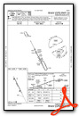
Instrument Approach Procedure (IAP) Charts

Nearby Airports with Instrument Procedures
| ID | Name | Heading / Distance | ||
|---|---|---|---|---|
 |
KAGZ | Wagner Municipal Airport | 215° | 23.1 |
|
KMHE | Mitchell Municipal Airport | 354° | 23.9 |
|
KYKN | Chan Gurney Municipal Airport | 135° | 38.3 |
|
4X4 | Wessington Springs Airport | 330° | 47.4 |
|
6K3 | Creighton Municipal Airport | 175° | 54.6 |
|
KMDS | Madison Municipal Airport | 045° | 54.9 |
|
KFSD | Joe Foss Field Airport | 076° | 55.9 |
|
0B4 | Hartington Municipal/Bud Becker Field Airport | 144° | 56.6 |
|
KVMR | Harold Davidson Field Airport | 127° | 59.2 |
|
KHON | Huron Regional Airport | 350° | 61.3 |
|
9V9 | Chamberlain Municipal Airport | 292° | 62.6 |
|
9D1 | Gregory Municipal/Flynn Field Airport | 261° | 62.6 |
Airport Images
Do you have a recent image of this airport? Upload it here!


