Login
Register


MEI
Key Field Airport
Official FAA Data Effective 2026-01-22 0901Z
Chart Supplement

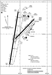
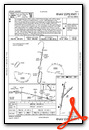
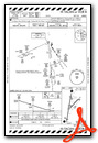
KMEI Airport Diagram
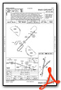
VFR Chart of KMEI
Sectional Charts at SkyVector.com
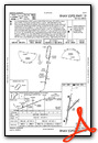
IFR Chart of KMEI
Enroute Charts at SkyVector.com
Location Information for KMEI
Coordinates: N32°19.97' / W88°45.09'Located 03 miles SW of Meridian, Mississippi on 1000 acres of land. View all Airports in Mississippi.
Surveyed Elevation is 297 feet MSL.
Operations Data
|
|
Airport Communications
| ATIS: | 126.475 291.675 |
|---|---|
| ASOS: | Tel. 601-207-0082 |
| KEY TOWER: | 133.975 257.8 |
| KEY GROUND: | 121.9 348.6 |
| MERIDIAN APPROACH: | 120.5 269.325 |
| MERIDIAN DEPARTURE: | 120.5 269.325 |
| CLEARANCE DELIVERY: | 121.9 348.6 |
| UNICOM: | 122.950 |
| CTAF: | 133.975 |
| EMERG: | 121.5 243.0 |
| ATIS at NMM (16.6 NE): | 290.525 |
| AWOS-3P at MPE (33.8 NW): | 118.725 601-663-0040 |
| AWOS-3P at DYA (41.2 E): | 119.475 |
- APCH/DEP SVC PRVDD BY MEMPHIS ARTCC ON FREQS 125.975/351.7 (MERIDIAN RCAG) WHEN MERIDIAN APCH CTL CLSD.
Nearby Navigation Aids
|
| ||||||||||||||||||||||||||||||||||||||||||||||||


Runway 01/19
NON-STD RESA DUE TO SFC VARNS. | ||
| Dimensions: | 10003 x 150 feet / 3049 x 46 meters | |
|---|---|---|
| Surface: | Asphalt-Concrete in Good Condition DTHR CONC. | |
| Weight Limits: | S-120, D-250, ST-550
PCR VALUE: 730/F/C/W/U
| |
| Edge Lighting: | High Intensity | |
| Runway 01 | Runway 19 | |
| Coordinates: | N32°19.06' / W88°45.38' | N32°20.69' / W88°45.07' |
| Elevation: | 286.0 | 293.5 |
| Runway Heading: | 9° True | 189° True |
| Displaced Threshold: | 990 Feet | 990 Feet |
| Declared Distances: | TORA:10003 TODA:10003 ASDA:10003 LDA:9013 | TORA:10003 TODA:10003 ASDA:10003 LDA:9013 |
| Markings: | Precision Instrument in good condition. | Precision Instrument in good condition. |
| Glide Slope Indicator | P4L (3.00° Glide Path Angle) | P4L (3.00° Glide Path Angle) |
| RVR Equipment | Touchdown | Touchdown |
| Approach Lights: | MALSR 1,400 Foot Medium-intensity Approach Lighting System with runway alignment indicator lights. | MALSR 1,400 Foot Medium-intensity Approach Lighting System with runway alignment indicator lights. |
Runway 04/22
| Dimensions: | 5052 x 150 feet / 1540 x 46 meters | |
|---|---|---|
| Surface: | Asphalt in Excellent Condition | |
| Weight Limits: | S-120, D-213, ST-345
PCR VALUE: 120/F/C/W/U
| |
| Edge Lighting: | Medium Intensity | |
| Runway 04 | Runway 22 | |
| Coordinates: | N32°19.86' / W88°45.17' | N32°20.46' / W88°44.49' |
| Elevation: | 289.8 | 297.0 |
| Traffic Pattern: | Left | Left |
| Runway Heading: | 44° True | 224° True |
| Declared Distances: | TORA:5052 TODA:5052 ASDA:5052 LDA:5052 | TORA:5052 TODA:5052 ASDA:5052 LDA:5052 |
| Markings: | Non-Precision Instrument in good condition. | Non-Precision Instrument in good condition. |
| Glide Slope Indicator | P2L (3.13° Glide Path Angle) | P2L (3.00° Glide Path Angle) |
| Obstacles: | 86 ft Trees 1926 ft from runway, 444 ft left of center | 35 ft Pole 1125 ft from runway, 390 ft right of center |
Services Available
| Fuel: | 100LL (blue), Jet-A, A++ |
|---|---|
| Transient Storage: | Hangars,Tiedowns |
| Airframe Repair: | MAJOR |
| Engine Repair: | MAJOR |
| Bottled Oxygen: | NOT AVAILABLE |
| Bulk Oxygen: | HIGH/LOW |
| Other Services: | AIR AMBULANCE SERVICES,AVIONICS,CARGO HANDLING SERVICES,CHARTER SERVICE,PILOT INSTRUCTION,AIRCRAFT RENTAL |
Ownership Information
| Ownership: | Publicly owned | |
|---|---|---|
| Owner: | MERIDIAN ARPT AUTH | |
| 2811A AIRPORT BLVD | ||
| MERIDIAN, MS 39307 | ||
| 601-482-0364 | ||
| Manager: | TOM WILLIAMS | |
| 2811A AIRPORT BLVD | ||
| MERIDIAN, MS 39307 | ||
| 601-482-0364 | ||
Other Remarks
- THIS AIRPORT HAS BEEN SURVEYED BY THE NATIONAL GEODETIC SURVEY.
- ANG ATNDD 0700-1630 MON-FRI EXCP HOLS.
- ANG LTD PRKG USE; RSC INFO AVBL FOR ANG OPS DURG NML DUTY HRS. ALL TRAN ACFT 48 HR PPR. OBO.
- ANG RAMP CLSD EXC PPR, 601-484-9734/9714. ARNG DSN 293-2829 C601-696-8829.
- BASH PHASE II PERIOD MAR-MAY, SEP-NOV. CTC AFLD MGMT OR COMD POST FOR CURRENT BIRD WATCH COND.
- ANG PROVIDES ATC SERVICES AT KMEI.
- FOR CD CTC MEMPHIS ARTCC AT 901-368-8453/8449.
- ACTVT MALSR RWY 01 & 19; MIRL RWY 04/22; HIRL RWY 01/19; TWY LGTS - CTAF.
Weather Minimums
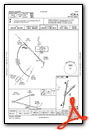
Instrument Approach Procedure (IAP) Charts
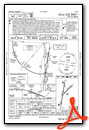


Nearby Airports with Instrument Procedures
| ID | Name | Heading / Distance | ||
|---|---|---|---|---|
 |
KNMM | Meridian NAS (Mc Cain Field) Airport | 036° | 16.5 |
|
KMPE | Philadelphia Municipal Airport | 325° | 33.8 |
|
09A | Butler/Choctaw County Airport | 111° | 34.2 |
|
KDYA | Demopolis Regional Airport | 078° | 41.3 |
|
KLUL | Hesler/Noble Field Airport | 208° | 45.0 |
|
KLMS | Louisville/Winston County Airport | 342° | 51.2 |
|
KAIV | George Downer Airport | 031° | 54.2 |
|
7A0 | Greensboro Municipal Airport | 069° | 59.1 |
|
KPIB | Hattiesburg/Laurel Regional Airport | 210° | 59.8 |
|
5R1 | Roy Wilcox Airport | 151° | 59.9 |
|
17M | Magee Municipal Airport | 242° | 60.4 |
|
KOSX | Kosciusko-Attala County Airport | 318° | 60.5 |
Airport Images

By: jtrolinger

By: jtrolinger


Comments
KMEI Meridian
Just a wonderful experience all around. I don't normally fly into towered airports but this FBO is sooo good. Stop here if you are in the area.