Login
Register


LUL
Hesler/Noble Field Airport
Official FAA Data Effective 2026-01-22 0901Z
Chart Supplement

VFR Chart of KLUL
Sectional Charts at SkyVector.com
IFR Chart of KLUL
Enroute Charts at SkyVector.com
Location Information for KLUL
Coordinates: N31°40.38' / W89°10.37'Located 03 miles SW of Laurel, Mississippi on 1350 acres of land. View all Airports in Mississippi.
Surveyed Elevation is 238 feet MSL.
Operations Data
|
|
Airport Communications
| AWOS-3PT: | 119.275 Tel. 601-425-9792 |
|---|---|
| CTAF: | 123.050 |
| UNICOM: | 123.050 |
| AWOS-3PT at PIB (14.9 SW): | 128.325 601-584-6701 |
| ASOS at HBG (24.8 S): | 135.425 601-544-2185 |
| AWOS-3PT at 0R0 (39.9 SW): | 120.675 601-736-4983 |
- APCH/DEP SVC PRVDD BY HOUSTON ARTCC (ZHU) ON FREQS 126.8/327.8 (HATTIESBURG RCAG).
Nearby Navigation Aids
|
| ||||||||||||||||||||||||||||||||||||||||||||||||||||||||||||


Runway 13/31
| Dimensions: | 5513 x 150 feet / 1680 x 46 meters | |
|---|---|---|
| Surface: | Asphalt in Good Condition | |
| Weight Limits: | S-41, D-65, ST-110 | |
| Edge Lighting: | High Intensity | |
| Runway 13 | Runway 31 | |
| Coordinates: | N31°40.70' / W89°10.74' | N31°40.06' / W89°9.99' |
| Elevation: | 228.6 | 234.3 |
| Traffic Pattern: | Left | Left |
| Runway Heading: | 135° True | 315° True |
| Markings: | Non-Precision Instrument in fair condition. | Non-Precision Instrument in fair condition. |
| Glide Slope Indicator | P4L (3.00° Glide Path Angle) | P4L (3.00° Glide Path Angle) PAPI UNUSBL BYD 9 DEGS RIGHT OF CNTRLN. |
| REIL: | Yes | |
| Obstacles: | 55 ft Trees 2124 ft from runway | |
Services Available
| Fuel: | 100LL (blue), Jet A-1+ |
|---|---|
| Transient Storage: | Hangars,Tiedowns |
| Airframe Repair: | MINOR |
| Engine Repair: | MINOR |
| Bottled Oxygen: | NONE |
| Bulk Oxygen: | NONE |
Ownership Information
| Ownership: | Publicly owned | |
|---|---|---|
| Owner: | LAUREL AIRPORT AUTHORITY | |
| PO BOX 2335 | ||
| LAUREL, MS 39442 | ||
| 601-425-5121 | ||
| Manager: | MATTHEW OWENS | |
| PO BOX 2335 | ||
| LAUREL, MS 39442 | ||
| 601-425-5121 | ||
Other Remarks
- ULTRALIGHT & CROP DUST ACTV INVOF ARPT.
- FOR CD IF UNA TO CTC ON FSS FREQ, CTC HOUSTON ARTCC AT 281-230-5622.
- COURTESY VEHICLE AVBL.
- FULL SVC FUEL WITH CREDIT CARD.
- ACTVT REIL RWY 13; HIRL RWY 13/31 - CTAF. PAPI RWY 13 & 31 OPR CONSLY.
Weather Minimums
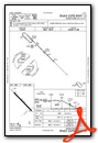
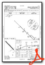
Instrument Approach Procedure (IAP) Charts
Nearby Airports with Instrument Procedures
| ID | Name | Heading / Distance | ||
|---|---|---|---|---|
 |
KPIB | Hattiesburg/Laurel Regional Airport | 214° | 14.9 |
|
KHBG | Hattiesburg Bobby L Chain Municipal Airport | 189° | 24.8 |
|
17M | Magee Municipal Airport | 289° | 34.1 |
|
M43 | Prentiss-Jefferson Davis County Airport | 263° | 37.9 |
|
0R0 | Columbia/Marion County Airport | 235° | 39.7 |
|
KMEI | Key Field Airport | 028° | 45.0 |
|
M24 | Dean Griffin Memorial Airport | 179° | 49.7 |
|
5R1 | Roy Wilcox Airport | 104° | 51.9 |
|
M13 | Poplarville/Pearl River County Airport | 197° | 55.7 |
|
09A | Butler/Choctaw County Airport | 063° | 59.7 |
|
KJAN | Jackson-Medgar Wiley Evers International Airport | 309° | 59.9 |
|
KNMM | Meridian NAS (Mc Cain Field) Airport | 030° | 61.4 |
Airport Images
Do you have a recent image of this airport? Upload it here!


