Login
Register


MEZ
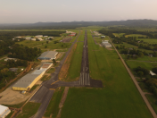
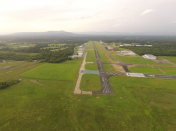
Mena Intermountain Municipal Airport
Official FAA Data Effective 2025-12-25 0901Z
Chart Supplement

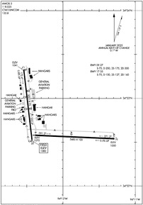
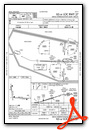
KMEZ Airport Diagram
VFR Chart of KMEZ
Sectional Charts at SkyVector.com
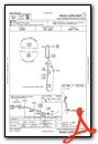
IFR Chart of KMEZ
Enroute Charts at SkyVector.com
Location Information for KMEZ
Coordinates: N34°32.73' / W94°12.14'Located 02 miles SE of Mena, Arkansas on 667 acres of land. View all Airports in Arkansas.
Estimated Elevation is 1079 feet MSL.
Operations Data
|
|
Airport Communications
| AWOS-3: | 118.025 Tel. 479-394-5149 |
|---|---|
| CTAF: | 122.800 |
| UNICOM: | 122.800 |
| ASOS at DEQ (31.5 S): | 134.075 870-642-7829 |
| AWOS-3 at RKR (35.1 NW): | 120.625 918-647-4063 |
| ASOS at FSM (48.0 N): | 479-649-2425 |
- APCH/DEP SVC PRVDD BY MEMPHIS ARTCC ON FREQS 126.1/269.0 (FAYETTEVILLE RCAG).
Nearby Navigation Aids
|
| ||||||||||||||||||||||||||||||||||||||||||||||||||||||||||||


Runway 09/27
| Dimensions: | 5485 x 100 feet / 1672 x 30 meters | |
|---|---|---|
| Surface: | Asphalt in Fair Condition | |
| Weight Limits: | S-75, D-200, ST-300 | |
| Edge Lighting: | Medium Intensity | |
| Runway 09 | Runway 27 | |
| Coordinates: | N34°32.58' / W94°12.38' | N34°32.54' / W94°11.29' |
| Elevation: | 1074.9 | 1050.1 |
| Runway Heading: | 92° True | 272° True |
| Markings: | Non-Precision Instrument in good condition. | Non-Precision Instrument in good condition. |
| Glide Slope Indicator | P4L (3.50° Glide Path Angle) PAPI RWY 9 UNUSBL BYD 7 DEG RIGHT OF CNTRLN. | P4L (3.00° Glide Path Angle) |
| REIL: | Yes | Yes |
Runway 17/35
| Dimensions: | 5001 x 75 feet / 1524 x 23 meters | |
|---|---|---|
| Surface: | Asphalt in Excellent Condition | |
| Weight Limits: | S-75, D-100, ST-160 | |
| Edge Lighting: | Medium Intensity | |
| Runway 17 | Runway 35 | |
| Coordinates: | N34°33.33' / W94°12.54' | N34°32.51' / W94°12.43' |
| Elevation: | 1040.7 | 1079.9 |
| Traffic Pattern: | Left | Left |
| Runway Heading: | 173° True | 353° True |
| Markings: | Non-Precision Instrument in good condition. | Non-Precision Instrument in good condition. |
| Glide Slope Indicator | P4L (3.00° Glide Path Angle) | |
| REIL: | Yes | |
| Obstacles: | 20 ft Tree 800 ft from runway, 55 ft right of center | 40 ft Tree 1200 ft from runway, 450 ft right of center |
Services Available
| Fuel: | 100LL (blue), Jet-A |
|---|---|
| Transient Storage: | Hangars,Tiedowns |
| Airframe Repair: | MAJOR |
| Engine Repair: | MAJOR |
| Bottled Oxygen: | LOW |
| Bulk Oxygen: | NONE |
| Other Services: | PILOT INSTRUCTION,AIRCRAFT RENTAL,AIRCRAFT SALES |
Ownership Information
| Ownership: | Publicly owned | |
|---|---|---|
| Owner: | CITY OF MENA | |
| 520 MENA ST | ||
| MENA, AR 71953 | ||
| 479-394-5800 | AFTER HOURS PLEASE CALL 479-394-4077 | |
| Manager: | FRED OGDEN | |
| 520 MENA ST | ||
| MENA, AR 71953 | ||
| 479-394-4077 | ||
Other Remarks
- MOUNTAINS NORTH AND SOUTH SOUTHWEST OF ARPT.
- MIGRATORY BIRDS & DEER ON & INVOF ARPT.
- FOR CD CTC MEMPHIS ARTCC AT 901-368-8453/8449.
- AS PER ALP
- MIRL RWY 09/27 OPR SS-SR. ACTVT PAPI RWYS 09, 27, & 17; MIRL RWY 17/35 - CTAF.
Weather Minimums
Instrument Approach Procedure (IAP) Charts
Nearby Airports with Instrument Procedures
| ID | Name | Heading / Distance | ||
|---|---|---|---|---|
 |
KDEQ | J Lynn Helms Sevier County Airport | 198° | 31.4 |
|
KRKR | Robert S Kerr Airport | 324° | 35.2 |
|
M77 | Howard County Airport | 151° | 37.5 |
|
KFSM | Fort Smith Regional Airport | 350° | 48.1 |
|
32A | Danville Municipal Airport | 049° | 50.1 |
|
4O4 | Mc Curtain County Regional Airport | 220° | 50.2 |
|
KHOT | Memorial Field Airport | 093° | 55.0 |
|
M18 | Hope Municipal Airport | 151° | 56.4 |
|
7M5 | Ozark/Franklin County Airport | 017° | 60.5 |
|
KJSV | Sallisaw Municipal Airport | 331° | 61.1 |
|
KADF | Dexter B Florence Memorial Field Airport | 114° | 62.5 |
|
KGZL | Stigler Regional Airport | 315° | 62.6 |