Login
Register


4O4
Mc Curtain County Regional Airport
Official FAA Data Effective 2026-02-19 0901Z
Chart Supplement

VFR Chart of 4O4
Sectional Charts at SkyVector.com
IFR Chart of 4O4
Enroute Charts at SkyVector.com
Location Information for 4O4
Coordinates: N33°54.56' / W94°51.56'Located 02 miles NW of Idabel, Oklahoma on 187 acres of land. View all Airports in Oklahoma.
Surveyed Elevation is 471 feet MSL.
Operations Data
|
|
Airport Communications
| AWOS-3: | 120.0 Tel. 580-286-2217 |
|---|---|
| CTAF: | 122.800 |
| UNICOM: | 122.800 |
| ASOS at DEQ (24.3 E): | 134.075 870-642-7829 |
| AWOS-3PT at PRX (33.8 SW): | 119.675 903-737-8784 |
| AWOS-3 at HHW (34.7 W): | 119.025 580-326-2134 |
- APCH/DEP CTL SVC PRVDD BY FORT WORTH ARTCC (ZFW) ON FREQS 123.925/269.475 (TEXARKANA RCAG).
Nearby Navigation Aids
|
| ||||||||||||||||||||||||||||||||||||||||||||||||||||||||||||


Runway 02/20
| Dimensions: | 5002 x 75 feet / 1525 x 23 meters | |
|---|---|---|
| Surface: | Asphalt in Good Condition | |
| Weight Limits: | S-30 | |
| Edge Lighting: | Medium Intensity | |
| Runway 02 | Runway 20 | |
| Coordinates: | N33°54.18' / W94°51.76' | N33°54.94' / W94°51.37' |
| Elevation: | 471.6 | 460.3 |
| Traffic Pattern: | Right | |
| Runway Heading: | 23° True | 203° True |
| Markings: | Non-Precision Instrument in good condition. | Non-Precision Instrument in good condition. |
| Glide Slope Indicator | P4L (3.00° Glide Path Angle) | P4L (3.00° Glide Path Angle) |
| Approach Lights: | ODALS Omnidirectional Approach Lighting System | |
| REIL: | Yes | |
| Obstacles: | 7 ft Trees 294 ft from runway, 90 ft left of center | |
Services Available
| Fuel: | 100LL (blue), Jet A+ |
|---|---|
| Transient Storage: | Hangars,Tiedowns |
| Airframe Repair: | NONE |
| Engine Repair: | MAJOR |
| Bottled Oxygen: | NOT AVAILABLE |
| Bulk Oxygen: | NOT AVAILABLE |
| Other Services: | AIR AMBULANCE SERVICES |
Ownership Information
| Ownership: | Publicly owned | |
|---|---|---|
| Owner: | MCCURTAIN CO. AIRPORT TRUST | |
| 201 EAST MAIN | ||
| IDABEL, OK 74745 | ||
| 580-286-7608 | ||
| Manager: | TORAN FRENCH | CODE ENFORCEMENT |
| 2907 NW. AIRPORT RD. | ||
| IDABEL, OK 74745 | ||
| 580-286-3558 | ||
Other Remarks
- FOR CD CTC FORT WORTH ARTCC AT 817-858-7584.
- ACTVT ODALS RWY 20; REIL RWY 02; PAPI RWY 02 & 20; MIRL RWY 02/20 - CTAF.
Weather Minimums

Instrument Approach Procedure (IAP) Charts
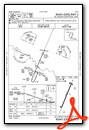

Nearby Airports with Instrument Procedures
| ID | Name | Heading / Distance | ||
|---|---|---|---|---|
 |
KDEQ | J Lynn Helms Sevier County Airport | 070° | 24.4 |
|
KPRX | Cox Field Airport | 241° | 33.8 |
|
KHHW | Stan Stamper Municipal Airport | 282° | 34.9 |
|
80F | Antlers Municipal Airport | 293° | 42.9 |
|
F53 | Franklin County Airport | 204° | 45.7 |
|
KOSA | Mount Pleasant Regional Airport | 186° | 48.9 |
|
KMEZ | Mena Intermountain Municipal Airport | 040° | 50.2 |
|
M77 | Howard County Airport | 083° | 51.2 |
|
KTXK | Texarkana Regional-Webb Field Airport | 121° | 51.3 |
|
KATA | Hall-Miller Municipal Airport | 145° | 58.7 |
|
KSLR | Sulphur Springs Municipal Airport | 220° | 58.9 |
|
M18 | Hope Municipal Airport | 100° | 61.1 |
Airport Images
Do you have a recent image of this airport? Upload it here!


