Login
Register


3F3
C E 'Rusty' Williams Airport
Official FAA Data Effective 2026-01-22 0901Z
Chart Supplement

VFR Chart of 3F3
Sectional Charts at SkyVector.com
IFR Chart of 3F3
Enroute Charts at SkyVector.com
Location Information for 3F3
Coordinates: N32°4.37' / W93°45.94'Located 03 miles NW of Mansfield, Louisiana on 1044 acres of land. View all Airports in Louisiana.
Surveyed Elevation is 324 feet MSL.
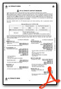
Operations Data
|
|
Airport Communications
| AWOS-3PT: | 119.125 Tel. 318-872-3537 |
|---|---|
| SHREVEPORT APPROACH: | 119.9 335.55 |
| SHREVEPORT DEPARTURE: | 119.9 335.55 |
| UNICOM: | 122.800 |
| CTAF: | 122.800 |
| ATIS at SHV (22.6 N): | 128.45 |
| ASOS at SHV (22.7 N): | 128.45 318-216-0546 |
| AWOS-3PT at F17 (24.7 SW): | 128.775 936-598-3355 |
Nearby Navigation Aids
|
| ||||||||||||||||||||||||||||||||||||||||||||||||||||||||||||


Runway 18/36
| Dimensions: | 5005 x 100 feet / 1526 x 30 meters | |
|---|---|---|
| Surface: | Asphalt in Good Condition | |
| Weight Limits: | S-12 | |
| Edge Lighting: | Medium Intensity | |
| Runway 18 | Runway 36 | |
| Coordinates: | N32°4.78' / W93°45.89' | N32°3.96' / W93°45.98' |
| Elevation: | 316.3 | 324.3 |
| Traffic Pattern: | Left | Left |
| Runway Heading: | 186° True | 6° True |
| Markings: | Non-Precision Instrument in fair condition. | Non-Precision Instrument in fair condition. |
| Glide Slope Indicator | P2L (3.00° Glide Path Angle) | P2L (3.50° Glide Path Angle) |
| REIL: | Yes | Yes |
| Obstacles: | 50 ft Trees 1609 ft from runway | 105 ft Trees 2043 ft from runway |
Services Available
| Fuel: | 100LL (blue), Jet-A |
|---|---|
| Transient Storage: | Hangars,Tiedowns |
| Airframe Repair: | NONE |
| Engine Repair: | NONE |
| Bottled Oxygen: | NONE |
| Bulk Oxygen: | NONE |
| Other Services: | CROP DUSTING SERVICES,PILOT INSTRUCTION |
Ownership Information
| Ownership: | Publicly owned | |
|---|---|---|
| Owner: | DE SOTO PARISH POLICE JURY | |
| 101 FRANKLIN ST | ||
| MANSFIELD, LA 71052 | ||
| (318) 871-8900 | ||
| Manager: | JACKIE MCKINNEY | |
| 211 INDEPENDENCE AVE | ||
| MANSFIELD, LA 71032 | ||
| (318) 871-7900 | ||
Other Remarks
- FOR CD CTC FORT WORTH ARTCC AT 817-858-7584.
- CTC ARPT MGR FOR DSGND RAMP SPACE FOR PUB USE AT ARPT
- 0LL FUEL AVBL 24 HRS WITH CREDIT CARD.
- CURRENTLY INOP
- MIRL RY 18/36 PRESET LOW INTST; TO INCR INTST & ACTVT REIL RYS 18 & 36 - CTAF.
Weather Minimums
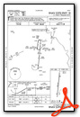
Instrument Approach Procedure (IAP) Charts
Nearby Airports with Instrument Procedures
| ID | Name | Heading / Distance | ||
|---|---|---|---|---|
 |
KSHV | Shreveport Regional Airport | 352° | 22.6 |
|
0R7 | The Red River Airport | 101° | 23.9 |
|
F17 | Center Municipal Airport | 234° | 24.6 |
|
KBAD | Barksdale AFB Airport | 011° | 26.2 |
|
4F2 | Panola County-Sharpe Field Airport | 282° | 27.9 |
|
KDTN | Shreveport Downtown Airport | 002° | 28.0 |
|
3R4 | Hart Airport | 155° | 34.8 |
|
KASL | Harrison County Airport | 314° | 38.5 |
|
KIER | Natchitoches Regional Airport | 120° | 39.6 |
|
KMNE | Minden Airport | 034° | 41.7 |
|
3F4 | Vivian Airport | 345° | 48.8 |
|
KGGG | East Texas Regional Airport | 291° | 51.6 |
Airport Images

By: Bandco


