Login
Register


MO3
Stockton Lake Airport
Official FAA Data Effective 2025-12-25 0901Z
Chart Supplement

VFR Chart of MO3
Sectional Charts at SkyVector.com
IFR Chart of MO3
Enroute Charts at SkyVector.com
Location Information for MO3
Coordinates: N37°39.62' / W93°49.01'Located 03 miles SW of Stockton, Missouri on 66 acres of land. View all Airports in Missouri.
Surveyed Elevation is 1042 feet MSL.
Operations Data
|
|
Airport Communications
| SPRINGFIELD APPROACH: | 124.95 |
|---|---|
| SPRINGFIELD DEPARTURE: | 124.95 |
| CTAF: | 122.900 |
| AWOS-3PT at NVD (25.9 NW): | 119.175 417-448-1635 |
| ATIS at SGF (32.2 SE): | 135.125 |
| ASOS at SGF (32.4 SE): | 417-869-4491 |
Nearby Navigation Aids
|
| ||||||||||||||||||||||||||||||||||||||||||||||||


Runway 01/19
| Dimensions: | 3060 x 50 feet / 933 x 15 meters | |
|---|---|---|
| Surface: | Asphalt in Good Condition | |
| Edge Lighting: | Low Intensity | |
| Runway 01 | Runway 19 | |
| Coordinates: | N37°39.37' / W93°49.10' | N37°39.86' / W93°48.92' |
| Elevation: | 1034.6 | 1037.1 |
| Traffic Pattern: | Left | Left |
| Runway Heading: | 16° True | 196° True |
| Markings: | Non-Precision Instrument in good condition. | Non-Precision Instrument in good condition. |
| Obstacles: | 43 ft Trees 795 ft from runway, 125 ft right of center | 25 ft Pole 288 ft from runway, 227 ft left of center |
Services Available
| Fuel: | 100LL (blue) |
|---|---|
| Transient Storage: | Tiedowns |
| Airframe Repair: | NOT AVAILABLE |
| Engine Repair: | NOT AVAILABLE |
| Bottled Oxygen: | NONE |
| Bulk Oxygen: | NONE |
Ownership Information
| Ownership: | Publicly owned | |
|---|---|---|
| Owner: | OPHELIA AIR LLC | |
| 14132 E 1560 RD | ||
| STOCKTON, MO 65785 | ||
| 417-276-7306 | ||
| Manager: | DIANNA SAATHOFF | CITY OF STOCKTON/CITY PUBLIC WORKS SUPERVISOR |
| 14132 E 1560 RD | ||
| STOCKTON, MO 65785 | ||
| 417-276-7306 | ||
Other Remarks
- WILDLIFE ON & INVOF ARPT.
- FUEL PUMPS 100LL SELF SVC 24/7
- COURTESY CAR AVBL
- FOR CD CTC SPRINGFIELD APCH AT 417-868-5620/5619.
Weather Minimums
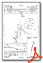
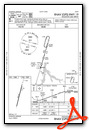
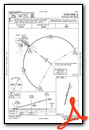
Instrument Approach Procedure (IAP) Charts
Nearby Airports with Instrument Procedures
| ID | Name | Heading / Distance | ||
|---|---|---|---|---|
 |
M17 | Bolivar Municipal Airport | 099° | 22.7 |
|
KLLU | Lamar Municipal Airport | 246° | 25.8 |
|
KNVD | Nevada Municipal Airport | 296° | 25.9 |
|
KSGF | Springfield-Branson Ntl Airport | 140° | 32.2 |
|
3DW | Downtown Airport | 133° | 37.8 |
|
KGLY | Clinton Regional Airport | 008° | 42.1 |
|
2H2 | Jerry Sumners Sr Aurora Municipal Airport | 172° | 42.2 |
|
KJLN | Joplin Regional Airport | 227° | 44.6 |
|
KBUM | Butler Memorial Airport | 326° | 45.2 |
|
KPTS | Atkinson Municipal Airport | 254° | 45.4 |
|
KFSK | Fort Scott Municipal Airport | 280° | 46.1 |
|
KHFJ | Monett Regional Airport | 191° | 46.2 |
Airport Images

By: val.foreit


