Login
Register
M17
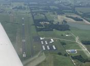
Bolivar Municipal Airport
Official FAA Data Effective 2026-01-22 0901Z
VFR Chart of M17
Sectional Charts at SkyVector.com
IFR Chart of M17
Enroute Charts at SkyVector.com
Location Information for M17
Coordinates: N37°35.77' / W93°20.86'Located 04 miles E of Bolivar, Missouri on 183 acres of land. View all Airports in Missouri.
Surveyed Elevation is 1092 feet MSL.
Operations Data
|
|
Airport Communications
| SPRINGFIELD APPROACH: | 124.95 318.2 |
|---|---|
| SPRINGFIELD DEPARTURE: | 124.95 318.2 |
| CTAF: | 123.000 |
| UNICOM: | 123.000 |
| ATIS at SGF (21.1 S): | 135.125 |
| ASOS at SGF (21.5 S): | 417-869-4491 |
| AWOS-3PT at LBO (33.1 E): | 118.975 417-533-3419 |
Nearby Navigation Aids
|
| ||||||||||||||||||||||||||||||||||||||||||||||||
Runway 18/36
| Dimensions: | 4000 x 75 feet / 1219 x 23 meters | |
|---|---|---|
| Surface: | Asphalt in Excellent Condition | |
| Weight Limits: | S-12 | |
| Edge Lighting: | Medium Intensity | |
| Runway 18 | Runway 36 | |
| Coordinates: | N37°36.08' / W93°20.87' | N37°35.42' / W93°20.90' |
| Elevation: | 1092.3 | 1092.3 |
| Runway Heading: | 183° True | 3° True |
| Markings: | Non-Precision Instrument in good condition. | Non-Precision Instrument in good condition. |
| Glide Slope Indicator | P2L (3.75° Glide Path Angle) | P2L (3.00° Glide Path Angle) |
Services Available
| Fuel: | 100LL (blue), Jet-A |
|---|---|
| Transient Storage: | Tiedowns |
| Airframe Repair: | MAJOR |
| Engine Repair: | MAJOR |
| Bottled Oxygen: | NOT AVAILABLE |
| Bulk Oxygen: | NOT AVAILABLE |
| Other Services: | AIR AMBULANCE SERVICES,PILOT INSTRUCTION,AIRCRAFT RENTAL |
Ownership Information
| Ownership: | Publicly owned | |
|---|---|---|
| Owner: | CITY OF BOLIVAR | |
| BOX 9 345 S MAIN | ||
| BOLIVAR, MO 65613 | ||
| 417-326-2489 | ||
| Manager: | KERRICK TWEEDY | |
| 4460 ARPT DR | ||
| BOLIVAR, MO 65613 | ||
| 417-777-6800 | FAX: 417-777-5558 | |
Other Remarks
- EXTENSIVE STUDENT PILOT TRAINING INVOF ARPT.
- WILDLIFE & BIRDS ON & INVOF ARPT.
- FOR CD CTC SPRINGFIELD APCH AT 417-868-5620/5619.
- 0LL FUEL CREDIT CARD SYS 100 LL AND JET A 24 HRS AVAIL.
- RY 18/36 MIRL DUSK-2330; AFT 2330 ACTVT - CTAF.
Weather Minimums
Instrument Approach Procedure (IAP) Charts
Nearby Airports with Instrument Procedures
| ID | Name | Heading / Distance | ||
|---|---|---|---|---|
 |
KSGF | Springfield-Branson Ntl Airport | 185° | 21.1 |
 |
MO3 | Stockton Lake Airport | 279° | 22.7 |
 |
3DW | Downtown Airport | 167° | 22.9 |
 |
KLBO | Floyd W Jones Lebanon Airport | 084° | 33.3 |
 |
KOZS | Camdenton Memorial-Lake Regional Airport | 053° | 38.6 |
 |
2H2 | Jerry Sumners Sr Aurora Municipal Airport | 203° | 41.5 |
 |
K15 | Grand Glaize-Osage Beach Airport | 045° | 44.2 |
 |
KRAW | Warsaw Municipal Airport | 000° | 45.1 |
 |
KLLU | Lamar Municipal Airport | 262° | 46.5 |
 |
KNVD | Nevada Municipal Airport | 288° | 48.1 |
 |
KGLY | Clinton Regional Airport | 341° | 48.1 |
 |
KAIZ | Lee C Fine Memorial Airport | 051° | 48.3 |


